Please click here for the updated version of this post
This Post covers
- Coverage Area of Postcode TW1 to TW9
- Total Sales By Postcode TW1 to TW9
- Average & Median Sales Price By Postcode TW1 to TW9
- Total Number of Sales By Postcode TW1 to TW9
- Multi Year Property Trend Analysis By Postcode TW1 to TW9
- Schools for Postcode Area TW
- Posts for Postcode Area TW
Coverage Area of Postcode TW1 to TW9
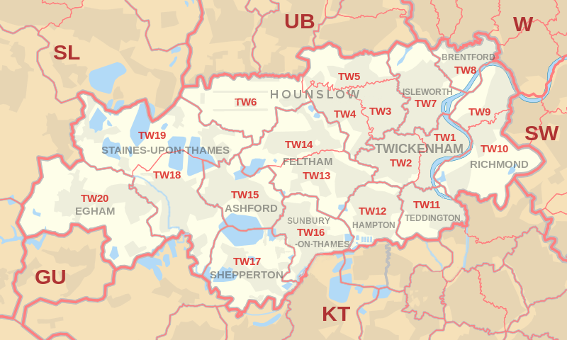 |
| Postcode |
Coverage Area |
Local Authority Area |
| TW1 |
Twickenham, St. Margarets, Strawberry Hill (east) |
Hounslow, Richmond upon Thames |
| TW2 |
Twickenham, Whitton, Strawberry Hill (west), Fulwell (north) |
Richmond Upon Thames |
| TW3 |
Hounslow, Lampton, Whitton (north) |
Hounslow, Richmond upon Thames |
| TW4 |
Hounslow West, Hounslow Heath, Whitton (west), Cranford (south) |
Hounslow, Richmond upon Thames |
| TW5 |
Heston, Cranford (north), Osterley (west) |
Hounslow |
| TW6 |
Heathrow Airport |
Hillingdon |
| TW7 |
Isleworth, Osterley (east and centre) |
Hounslow, Richmond upon Thames |
| TW8 |
Brentford, Kew Bridge, Syon Park |
Hounslow, Ealing |
| TW9 |
Richmond, Kew, North Sheen (north) |
Richmond Upon Thames |
Total Sales By Postcode in 2016
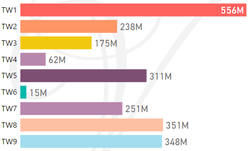
*M represents millions
Average & Median Sales Price By Postcode in 2016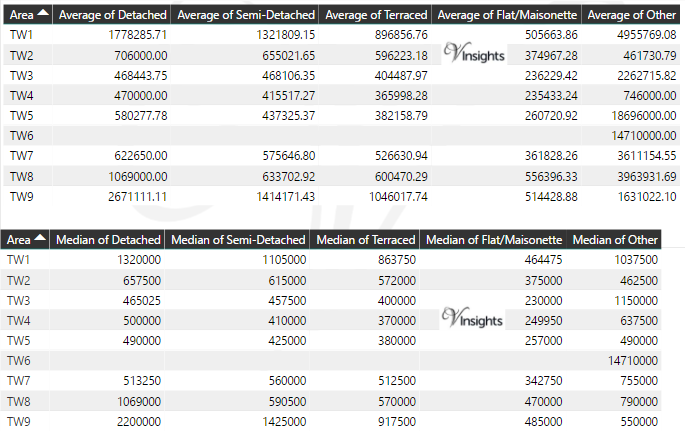
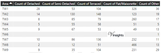
Total Number Of Sales By Postcode in 2016
Multi Year Property Trend Analysis By Postcode
Schools for Postcode Area TW
- London TW Postcode Area - TW1, TW2, TW3, TW4, TW5, TW6, TW7, TW8, TW9 School Details
- London TW Postcode Area - TW10, TW11, TW12, TW13, TW14, TW15, TW16, TW17, TW18, TW19, TW20 School Details
Posts for Postcode Area TW
All TW Postcode Area Posts

Reference
TW Postcode Area As Per Wikipedia
f255b59a-f973-4eda-8a32-2df796355580|0|.0|27604f05-86ad-47ef-9e05-950bb762570c
Please click here for the updated version of this post
This Post covers
- Coverage Area of Postcode SW10 to SW20
- Total Sales By Postcode SW10 to SW20
- Average & Median Sales Price By Postcode SW10 to SW20
- Total Number of Sales By Postcode SW10 to SW20
- Multi Year Property Trend Analysis By Postcode SW10 to SW20
- Schools for Postcode Area SW
- Posts for Postcode Area SW
Coverage Area of Postcode SW10 to SW20
 |
| Postcode |
Coverage Area |
Local Authority Area |
| SW10 |
West Brompton, Chelsea (west) |
Hammersmith and Fulham, Kensington and Chelsea |
| SW11 |
Battersea, Clapham South |
Lambeth, Wandsworth |
| SW12 |
Balham, Clapham South, Wandsworth Common (part) |
Lambeth, Wandsworth |
| SW13 |
Barnes |
Richmond Upon Thames,Merton |
| SW14 |
Mortlake, East Sheen |
Richmond Upon Thames,Merton |
| SW15 |
Kingston Vale, Putney, Putney Heath, Putney Vale, Richmond Park, Roehampton, Roehampton Vale |
Kingston Upon Thames, Richmond Upon Thames, Wandsworth,Merton |
| SW16 |
Streatham, Streatham Common, Norbury, Thornton Heath, Streatham Park, Furzedown, Streatham Vale, Mitcham Common, Pollards Hill, Eastfields |
Croydon, Lambeth, Merton, Wandsworth |
| SW17 |
Tooting, Mitcham (part) Balham (part) |
Merton, Wandsworth |
| SW18 |
Wandsworth, Southfields, Earlsfield |
Wandsworth,Merton |
| SW19 |
Wimbledon, Colliers Wood, Merton Park, Merton Abbey, Southfields, Morden (part) |
Merton, Wandsworth |
| SW20 |
Raynes Park, Lower Morden, Merton Park, Wimbledon Chase |
Merton, Kingston upon Thames |
Total Sales By Postcode in 2016
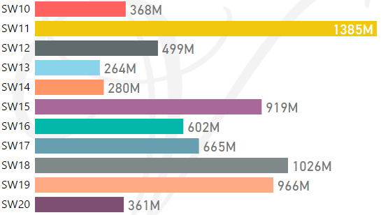
*M represents millions
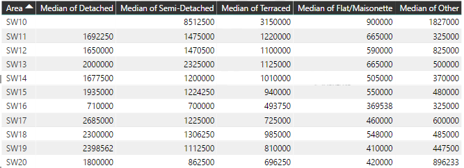
Average & Median Sales Price By Postcode in 2016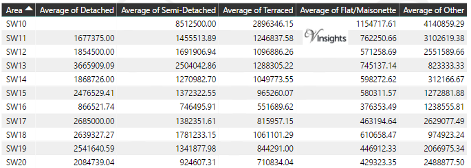
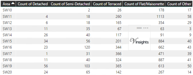
Total Number Of Sales By Postcode in 2016
Multi Year Property Trend Analysis By Postcode
Schools for Postcode Area SW
- London SW Postcode Area - SW1A, SW1E, SW1H, SW1P, SW1V, SW1W, SW1X, SW1Y School Details
- London SW Postcode Area - SW2, SW3, SW4, SW5, SW6, SW7, SW8, SW9 School Details
- London SW Postcode Area - SW10, SW11, SW12, SW13, SW14, SW15, SW16, SW17, SW18, SW19, SW20 School Details
Posts for Postcode Area SW
All SW Postcode Area Posts
Reference
SW Postcode Area As Per Wikipedia
863be269-fb53-42c2-a8e5-f3ef9222110b|0|.0|27604f05-86ad-47ef-9e05-950bb762570c
Tags :
SW10 Property Sales ,
SW11 Property Sales ,
SW12 Property Sales ,
SW13 Property Sales ,
SW14 Property Sales ,
SW15 Property Sales ,
SW16 Property Sales ,
SW17 Property Sales ,
SW18 Property Sales ,
SW19 Property Sales ,
SW20 Property Sales
Please click here for the updated version of this post
This Post covers
- Coverage Area of Postcode SW2 to SW9
- Total Sales By Postcode SW2 to SW9
- Average & Median Sales Price By Postcode SW2 to SW9
- Total Number of Sales By Postcode SW2 to SW9
- Multi Year Property Trend Analysis By Postcode SW2 to SW9
- Schools for Postcode Area SW
- Posts for Postcode Area SW
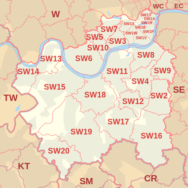
Coverage Area of Postcode SW2 to SW9
| |
| Postcode |
Coverage Area |
Local Authority Area |
| SW2 |
Brixton, Brixton Hill, Streatham Hill, Tulse Hill, Clapham Park, Eastern parts of Balham |
Lambeth |
| SW3 |
Chelsea, Brompton, Knightsbridge (part) |
Kensington and Chelsea |
| SW4 |
Clapham, Stockwell(part) |
Lambeth, Wandsworth |
| SW5 |
Earls Court |
Kensington and Chelsea |
| SW6 |
Fulham, Parsons Green |
Hammersmith and Fulham |
| SW7 |
South Kensington, Knightsbridge (part) |
Kensington and Chelsea, Westminster |
| SW8 |
South Lambeth, Vauxhall, Battersea (part), Wandsworth Road, Clapham (part), NW area of Stockwell |
Lambeth, Wandsworth |
| SW9 |
Stockwell, Brixton (part), Clapham (part), Oval (part) |
Lambeth |
Total Sales By Postcode in 2016
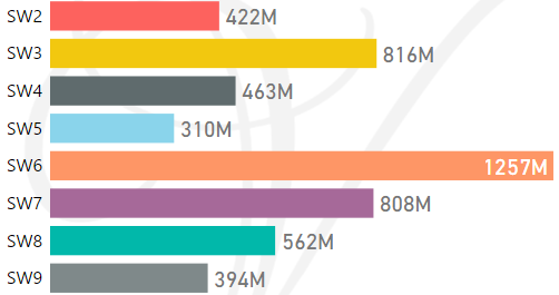
*M represents millions
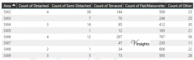
Average & Median Sales Price By Postcode in 2016
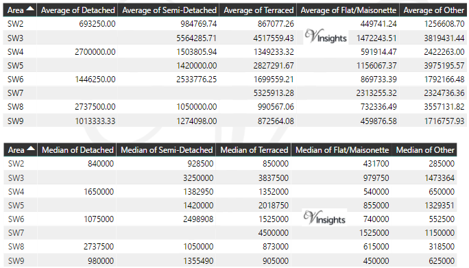
Total Number Of Sales By Postcode in 2016
Multi Year Property Trend Analysis By Postcode
Schools for Postcode Area SW
- London SW Postcode Area - SW1A, SW1E, SW1H, SW1P, SW1V, SW1W, SW1X, SW1Y School Details
- London SW Postcode Area - SW2, SW3, SW4, SW5, SW6, SW7, SW8, SW9 School Details
- London SW Postcode Area - SW10, SW11, SW12, SW13, SW14, SW15, SW16, SW17, SW18, SW19, SW20 School Details
Posts for Postcode Area SW
All SW Postcode Area Posts
Reference
SW Postcode Area As Per Wikipedia
63b4f625-70fe-40ba-8471-04079d0593ce|0|.0|27604f05-86ad-47ef-9e05-950bb762570c
Please click here for the updated version of this post
This Post covers
- Coverage Area of Postcode SW1A to SW1Y
- Total Sales By Postcode SW1A to SW1Y
- Average & Median Sales Price By Postcode SW1A to SW1Y
- Total Number of Sales By Postcode SW1A to SW1Y
- Multi Year Property Trend Analysis By Postcode SW1A to SW1Y
- Schools for Postcode Area SW
- Posts for Postcode Area SW
Coverage Area of Postcode SW1A to SW1Y
 |
| Postcode |
Coverage Area |
Local Authority Area |
| SW1A |
Whitehall and Buckingham Palace |
Westminster |
| SW1E |
Between Buckingham Gate and Victoria Station |
Westminster |
| SW1H |
East of Buckingham Gate |
Westminster |
| SW1P |
Triangular area between Victoria Station, the Houses of Parliament, and Vauxhall Bridge |
Westminster |
| SW1V |
Triangular area between Vauxhall Bridge, Chelsea Bridge, and Victoria Station; Pimlico proper |
Westminster |
| SW1W |
Belgravia, Chelsea (part), area between Sloane Square and Victoria Station, south of Kings Road |
Kensington and Chelsea, Westminster |
| SW1X |
Belgravia, north of Eaton Square, Knightsbridge (part), Chelsea (part) |
Kensington and Chelsea, Westminster |
| SW1Y |
St James's |
Westminster |
Total Sales By Postcode in 2016
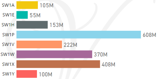
*M represents millions
Average & Median Sales Price By Postcode in 2016
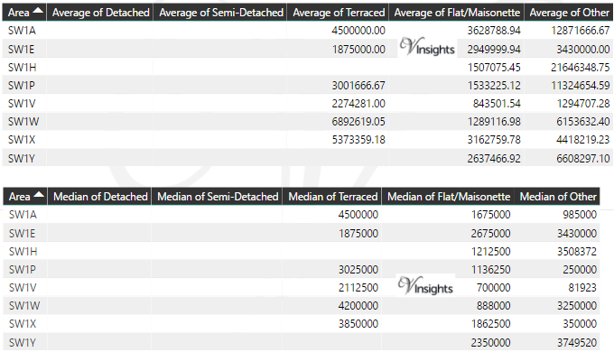
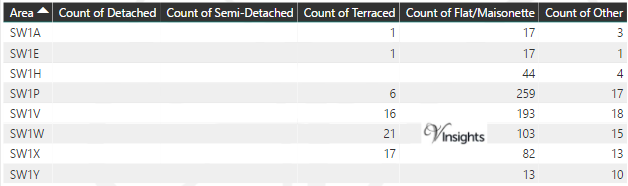
Total Number Of Sales By Postcode in 2016
Multi Year Property Trend Analysis By Postcode
Schools for Postcode Area SW
- London SW Postcode Area - SW1A, SW1E, SW1H, SW1P, SW1V, SW1W, SW1X, SW1Y School Details
- London SW Postcode Area - SW2, SW3, SW4, SW5, SW6, SW7, SW8, SW9 School Details
- London SW Postcode Area - SW10, SW11, SW12, SW13, SW14, SW15, SW16, SW17, SW18, SW19, SW20 School Details
Posts for Postcode Area SW
All SW Postcode Area Posts
Reference
SW Postcode Area As Per Wikipedia
03439a67-6f47-4026-9d2b-59b6d28202d9|0|.0|27604f05-86ad-47ef-9e05-950bb762570c
Please click here for the updated version of this post
This Post covers
- Coverage Area of Postcode SM1 to SM7
- Total Sales By Postcode SM1 to SM7
- Average & Median Sales Price By Postcode SM1 to SM7
- Total Number of Sales By Postcode SM1 to SM7
- Multi Year Property Trend Analysis By Postcode SM1 to SM7
- Schools for Postcode Area SM
- Posts for Postcode Area SM
Coverage Area of Postcode SM1 to SM7
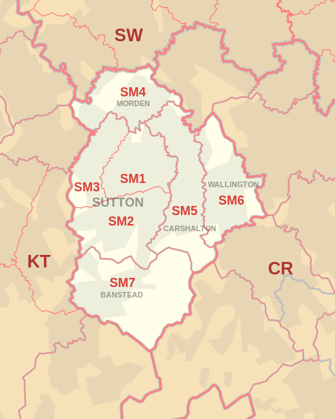 |
| Postcode |
Coverage Area |
Local Authority Area |
| SM1 |
Sutton, Rosehill, Parts of The Wrythe and Carshalton, Benhilton and Erskine Village, the eastern part of Sutton Common |
Sutton |
| SM2 |
Belmont, South Sutton, South Cheam, East Ewell |
Epsom and Ewell, Reigate and Banstead, Sutton |
| SM3 |
The western part of Sutton Common, North Cheam, Stonecot Hill |
Sutton,Merton |
| SM4 |
Morden, Morden Park, Lower Morden, St. Helier (West), Rosehill |
Merton, Sutton |
| SM5 |
Carshalton, Carshalton Beeches, Carshalton on the Hill, The Wrythe, Rosehill, St. Helier (South), Middleton Circle, Little Woodcote |
Sutton |
| SM6 |
Wallington, Beddington, Hackbridge, Roundshaw |
Sutton |
| SM7 |
Banstead, Woodmansterne, Nork, Little Woodcote |
Reigate and Banstead, Sutton |
Total Sales By Postcode in 2016
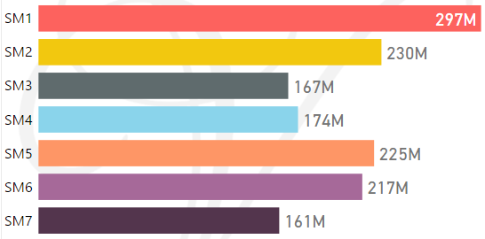
*M represents millions
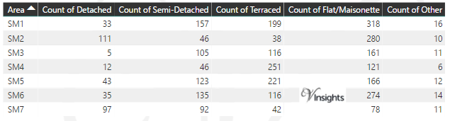
Average & Median Sales Price By Postcode in 2016
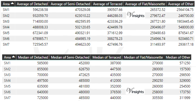
Total Number Of Sales By Postcode in 2016
Multi Year Property Trend Analysis By Postcode
Schools for Postcode Area SM
Posts for Postcode Area SM
All SM Postcode Area Posts
Reference
SM Postcode Area As Per Wikipedia
0104d1ed-8c9d-4d68-b78f-7894a910db4f|0|.0|27604f05-86ad-47ef-9e05-950bb762570c