Please click here for the updated version of this post
This Post covers
- Coverage Area of Postcode KT20 to KT24
- Total Sales By Postcode KT20 to KT24
- Average & Median Sales Price By Postcode KT20 to KT24
- Total Number of Sales By Postcode KT20 to KT24
- Multi Year Property Trend Analysis For Postcode KT20 to KT24
- Schools for Postcode Area KT
- Posts for Postcode Area KT
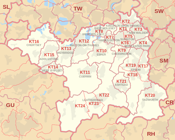
Coverage Area of Postcode KT20 to KT24
 |
| Postcode |
Coverage Area |
Local Authority Area |
| KT20 |
Tadworth, Kingswood, Lower Kingswood, Walton-on-the-Hill, Burgh Heath, Mogador, Box Hill |
Reigate and Banstead, Mole Valley |
| KT21 |
Ashtead |
Mole Valley |
| KT22 |
Leatherhead, Oxshott, Fetcham |
Mole Valley, Elmbridge |
| KT23 |
Great Bookham, Little Bookham |
Mole Valley, Guildford |
| KT24 |
West Horsley, East Horsley, Effingham |
Guildford, Mole Valley |
Total Sales By Postcode in 2016
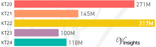
*M represents millions
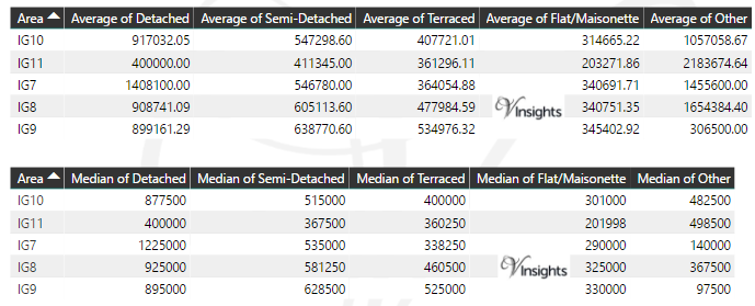
Average & Median Sales Price By Postcode in 2016
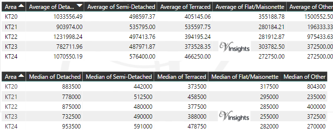
Total Number Of Sales By Postcode in 2016
Multi Year Property Trend Analysis By Postcode
Schools for Postcode Area KT
- KT Postcode Area - KT1, KT2, KT3, KT4, KT5, KT6, KT7, KT8, KT9 School Details
- KT Postcode Area - KT10, KT11, KT12, KT13, KT14, KT15, KT16, KT17, KT18, KT19 School Details
- KT Postcode Area - KT20, KT21, KT22, KT23, KT24 School Details
Posts for Postcode Area KT
All KT Postcode Area Posts

Reference
KT Postcode Area As Per Wikipedia
e67184fa-26d9-4c3a-bbb3-e919ba47d3c4|0|.0|27604f05-86ad-47ef-9e05-950bb762570c
Please click here for the updated version of this post
This Post covers
- Coverage Area of Postcode KT10 to KT19
- Total Sales By Postcode KT10 to KT19
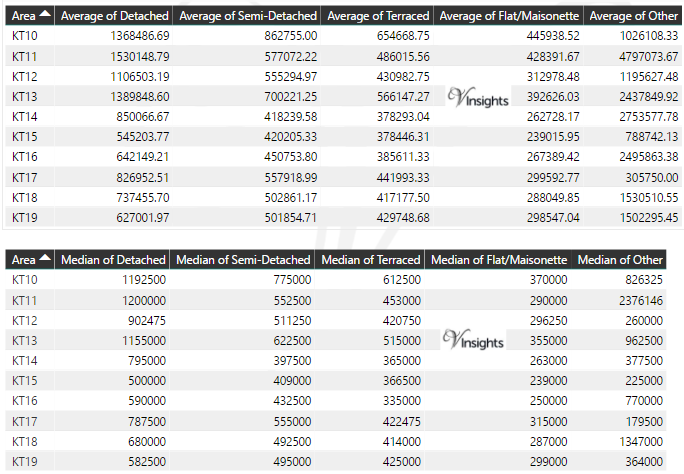
- Average & Median Sales Price By Postcode KT10 to KT19
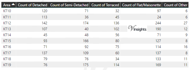
- Total Number of Sales By Postcode KT10 to KT19
- Multi Year Property Trend Analysis For Postcode KT10 to KT19
- Schools for Postcode Area KT
- Posts for Postcode Area KT
Coverage Area of Postcode KT10 to KT19
|
| Postcode |
Coverage Area |
Local Authority Area |
| KT10 |
Esher, Claygate, Hinchley Wood |
Elmbridge |
| KT11 |
Cobham, Stoke d'Abernon, Downside, Hatchford, parts of Wisley, Ockham and Hersham |
Elmbridge, Guildford, Mole Valley |
| KT12 |
Walton-on-Thames, Hersham, Whiteley Village |
Elmbridge |
| KT13 |
Weybridge, Oatlands, Saint George's Hill, Hamm Court |
Elmbridge, Runnymede |
| KT14 |
Byfleet, West Byfleet |
Woking, Elmbridge, Runnymede |
| KT15 |
Addlestone, New Haw, Woodham |
Runnymede, Woking |
| KT16 |
Chertsey, Ottershaw, Longcross, Lyne, Dumsey Meadow in Littleton |
Runnymede, Spelthorne |
| KT17 |
Epsom, Ewell, Stoneleigh |
Epsom and Ewell, Reigate and Banstead, Sutton |
| KT18 |
Epsom, Tattenham Corner, Headley, Langley Vale |
Epsom and Ewell, Mole Valley, Reigate and Banstead |
| KT19 |
Epsom, West Ewell, Stoneleigh, Horton, Longmead |
Epsom and Ewell |
Total Sales By Postcode in 2016
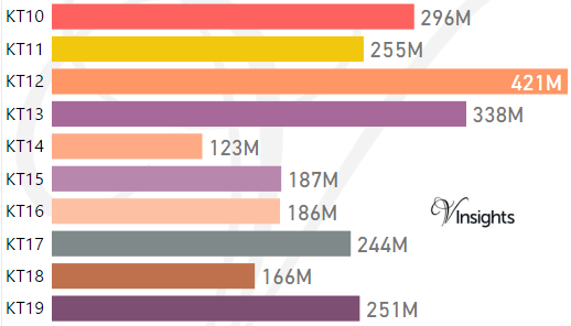
*M represents millions
Average & Median Sales Price By Postcode in 2016
Total Number Of Sales By Postcode in 2016
Multi Year Property Trend Analysis By Postcode
Schools for Postcode Area KT
- KT Postcode Area - KT1, KT2, KT3, KT4, KT5, KT6, KT7, KT8, KT9 School Details
- KT Postcode Area - KT10, KT11, KT12, KT13, KT14, KT15, KT16, KT17, KT18, KT19 School Details
- KT Postcode Area - KT20, KT21, KT22, KT23, KT24 School Details
Posts for Postcode Area KT
All KT Postcode Area Posts
Reference
KT Postcode Area As Per Wikipedia
b9486d21-8b93-46ea-a558-b008d6a47822|0|.0|27604f05-86ad-47ef-9e05-950bb762570c
Please click here for the updated version of this post
This Post covers
- Coverage Area of Postcode KT1 to KT9
- Total Sales By Postcode KT1 to KT9
- Average & Median Sales Price By Postcode KT1 to KT9
- Total Number of Sales By Postcode KT1 to KT9
- Multi Year Property Trend Analysis For Postcode KT1 to KT9
- Schools for Postcode Area KT
- Posts for Postcode Area KT
Coverage Area of Postcode KT1 to KT9
 |
| Postcode |
Coverage Area |
Local Authority Area |
| KT1 |
Kingston Upon Thames, Hampton Wick, Norbiton |
Kingston Upon Thames, Richmond upon Thames |
| KT2 |
Kingston Upon Thames, Canbury, Coombe |
Kingston Upon Thames, Richmond upon Thames |
| KT3 |
New Malden, part of Old Malden |
Kingston Upon Thames, Merton |
| KT4 |
Worcester Park, Cuddington, part of Old Malden, Stoneleigh |
Sutton, Epsom and Ewell, Kingston upon Thames |
| KT5 |
Surbiton, Berrylands, Tolworth |
Kingston Upon Thames |
| KT6 |
Surbiton, Tolworth, Long Ditton |
Kingston Upon Thames, Elmbridge |
| KT7 |
Thames Ditton, Weston Green |
Elmbridge |
| KT8 |
East Molesey, West Molesey, Hampton Court Palace and part of its Park; 1.5 Thames islands, part of Bushy Park, Hampton Court neighbourhood, Hampton |
Elmbridge, Richmond upon Thames |
| KT9 |
Chessington including Malden Rushett, Hook, part of Long Ditton |
Kingston Upon Thames, Elmbridge |
Total Sales By Postcode in 2016
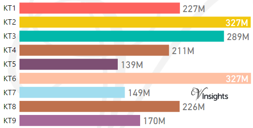
*M represents millions
Average & Median Sales Price By Postcode in 2016
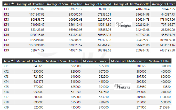
Total Number Of Sales By Postcode in 2016
Multi Year Property Trend Analysis By Postcode
Schools for Postcode Area KT
- KT Postcode Area - KT1, KT2, KT3, KT4, KT5, KT6, KT7, KT8, KT9 School Details
- KT Postcode Area - KT10, KT11, KT12, KT13, KT14, KT15, KT16, KT17, KT18, KT19 School Details
- KT Postcode Area - KT20, KT21, KT22, KT23, KT24 School Details
Posts for Postcode Area KT
All KT Postcodes Yearly & Trend Analysis Posts
Reference
KT Postcode Area As Per Wikipedia
c2965d3b-b192-438c-8b74-c9d8ebac530a|0|.0|27604f05-86ad-47ef-9e05-950bb762570c
Please click here for the updated version of this post
This Post covers
- Coverage Area of Postcode IG7 to IG11
- Total Sales By Postcode IG7 to IG11
- Average & Median Sales Price By Postcode IG7 to IG11
- Total Number of Sales By Postcode IG7 to IG11
- Multi Year Property Trend Analysis For Postcode IG7 to IG11
- Schools for Postcode Area IG
- Posts for Postcode Area IG
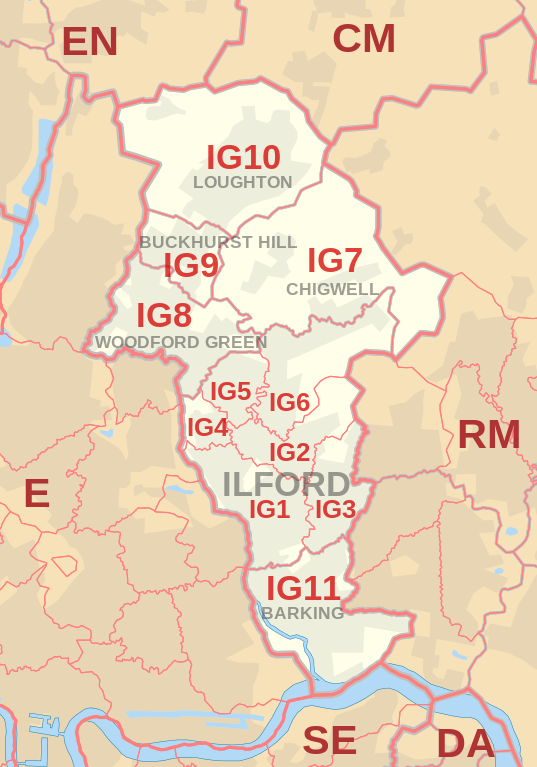
Coverage Area of Postcode IG7 to IG11
 |
| Postcode |
Coverage Area |
Local Authority Area |
| IG7 |
Chigwell, Chigwell Row, Hainault (north) |
Epping Forest, Redbridge |
| IG8 |
Woodford Green, Woodford Bridge, Highams Park (part) |
Redbridge, Waltham Forest |
| IG9 |
Buckhurst Hill |
Epping Forest,Redbridge |
| IG10 |
Loughton, High Beach (part) |
Epping Forest |
| IG11 |
Barking, Creekmouth |
Barking and Dagenham, Redbridge |
Total Sales By Postcode in 2016
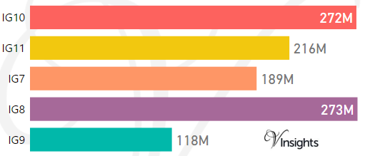
*M represents millions
Average & Median Sales Price By Postcode in 2016
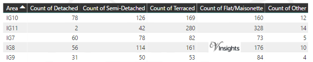
Total Number Of Sales By Postcode in 2016
Multi Year Property Trend Analysis By Postcode
Schools for Postcode Area IG
Posts for Postcode Area IG
All IG Postcode Area Posts
Reference
IG Postcode Area As Per Wikipedia
b9639e8f-037b-4918-b672-75942b22847f|0|.0|27604f05-86ad-47ef-9e05-950bb762570c
Please click here for the updated version of this post
This Post covers
- Coverage Area of Postcode IG1 to IG6
- Total Sales By Postcode IG1 to IG6
- Average & Median Sales Price By Postcode IG1 to IG6
- Total Number of Sales By Postcode IG1 to IG6
- Multi Year Property Trend Analysis For Postcode IG1 to IG6
- Schools for Postcode Area IG
- Posts for Postcode Area IG
Coverage Area of Postcode IG1 to IG6
 |
| Postcode |
Coverage Area |
Local Authority Area |
| IG1 |
Ilford, Cranbrook, Loxford |
Redbridge |
| IG2 |
Gants Hill, Newbury Park, Aldborough Hatch |
Redbridge |
| IG3 |
Seven Kings, Goodmayes |
Redbridge |
| IG4 |
Redbridge |
Redbridge |
| IG5 |
Clayhall |
Redbridge |
| IG6 |
Barkingside, Fullwell Cross, Hainault (south), Fairlop |
Redbridge |
Total Sales By Postcode in 2016
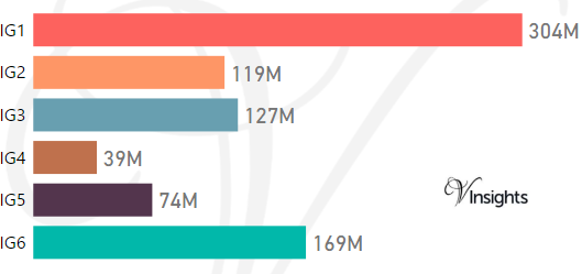
*M represents millions
Average & Median Sales Price By Postcode in 2016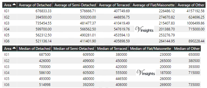
Total Number Of Sales By Postcode in 2016
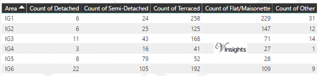
Multi Year Property Trend Analysis By Postcode
Schools for Postcode Area IG
Posts for Postcode Area IG
All IG Postcodes Yearly & Trend Analysis Posts
Reference
IG Postcode Area As Per Wikipedia
186b1529-8aa4-40f9-ad71-a27fa20f156b|0|.0|27604f05-86ad-47ef-9e05-950bb762570c