Please click here for the updated version of this post
This Post covers
- Coverage Area of Postcode SW2 to SW9
- Total Sales By Postcode SW2 to SW9
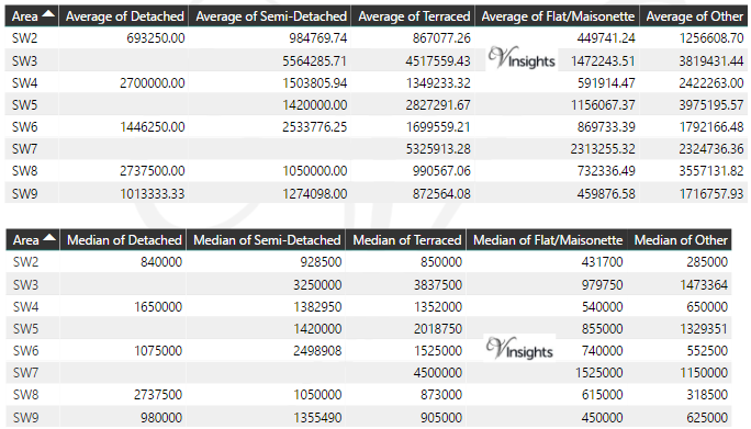
- Average & Median Sales Price By Postcode SW2 to SW9
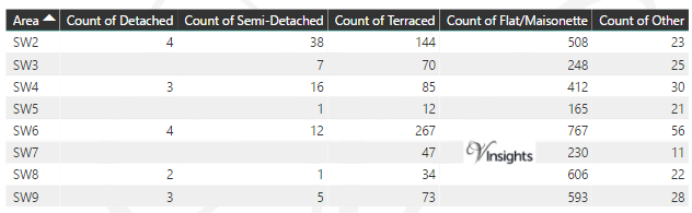
- Total Number of Sales By Postcode SW2 to SW9
- Multi Year Property Trend Analysis By Postcode SW2 to SW9
- Schools for Postcode Area SW
- Posts for Postcode Area SW
Coverage Area of Postcode SW2 to SW9
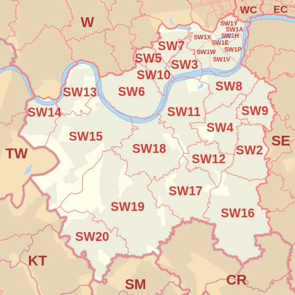 |
| Postcode |
Coverage Area |
Local Authority Area |
| SW2 |
Brixton, Brixton Hill, Streatham Hill, Tulse Hill, Clapham Park, Eastern parts of Balham |
Lambeth |
| SW3 |
Chelsea, Brompton, Knightsbridge (part) |
Kensington and Chelsea |
| SW4 |
Clapham, Stockwell(part) |
Lambeth, Wandsworth |
| SW5 |
Earls Court |
Kensington and Chelsea |
| SW6 |
Fulham, Parsons Green |
Hammersmith and Fulham |
| SW7 |
South Kensington, Knightsbridge (part) |
Kensington and Chelsea, Westminster |
| SW8 |
South Lambeth, Vauxhall, Battersea (part), Wandsworth Road, Clapham (part), NW area of Stockwell |
Lambeth, Wandsworth |
| SW9 |
Stockwell, Brixton (part), Clapham (part), Oval (part) |
Lambeth |
Total Sales By Postcode in 2016
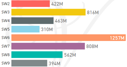
*M represents millions
Average & Median Sales Price By Postcode in 2016
Total Number Of Sales By Postcode in 2016
Multi Year Property Trend Analysis By Postcode
Schools for Postcode Area SW
- London SW Postcode Area - SW1A, SW1E, SW1H, SW1P, SW1V, SW1W, SW1X, SW1Y School Details
- London SW Postcode Area - SW2, SW3, SW4, SW5, SW6, SW7, SW8, SW9 School Details
- London SW Postcode Area - SW10, SW11, SW12, SW13, SW14, SW15, SW16, SW17, SW18, SW19, SW20 School Details
Posts for Postcode Area SW
All SW Postcode Area Posts

Reference
SW Postcode Area As Per Wikipedia
63b4f625-70fe-40ba-8471-04079d0593ce|0|.0|27604f05-86ad-47ef-9e05-950bb762570c