Please click here for the updated version of this post
This Post covers
- Coverage Area of Postcode RM10 to RM20
- Total Sales By Postcode RM10 to RM20
- Average & Median Sales Price By Postcode RM10 to RM20
- Total Number of Sales By Postcode RM10 to RM20
- Multi Year Property Trend Analysis By Postcode RM10 to RM20
- Schools for Postcode Area RM
- Posts for Postcode Area RM
Coverage Area of Postcode RM10 to RM20
 |
| Postcode |
Coverage Area |
Local Authority Area |
| RM10 |
Dagenham, Becontree |
Barking and Dagenham |
| RM11 |
Hornchurch, Emerson Park, Ardleigh Green |
Havering |
| RM12 |
Hornchurch, Elm Park |
Havering |
| RM13 |
Rainham, South Hornchurch, Wennington |
Havering |
| RM14 |
Upminster, Cranham, North Ockendon, Bulphan |
Havering, Thurrock |
| RM15 |
South Ockendon, Aveley |
Thurrock, Havering |
| RM16 |
Chafford Hundred, Chadwell St Mary, North Stifford, Orsett |
Thurrock |
| RM17 |
Grays, Badgers Dene |
Thurrock |
| RM18 |
Tilbury, East Tilbury, West Tilbury |
Thurrock |
| RM19 |
Purfleet |
Thurrock |
| RM20 |
West Thurrock, South Stifford |
Thurrock |
Total Sales By Postcode in 2016
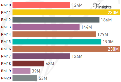
*M represents millions
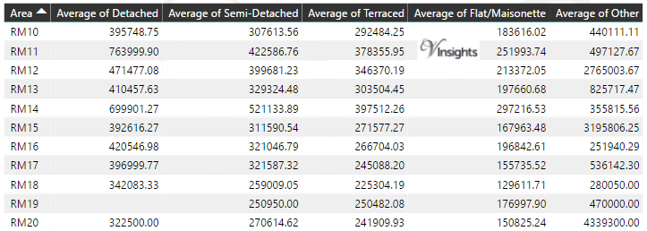
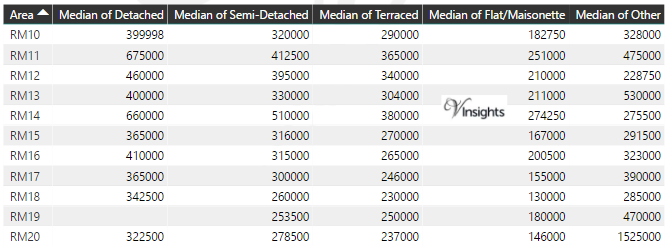
Average & Median Sales Price By Postcode in 2016
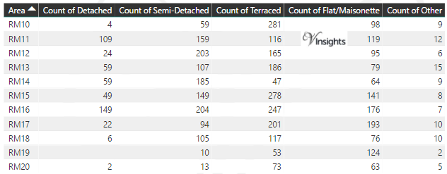
Total Number Of Sales By Postcode in 2016
Multi Year Property Trend Analysis By Postcode
Schools for Postcode Area RM
- RM Postcode Area - RM1, RM2, RM3, RM4, RM5, RM6, RM7, RM8, RM9 School Details
- RM Postcode Area - RM10, RM11, RM12, RM13, RM14, RM15, RM16, RM17, RM18, RM19, RM20 School Details
Posts for Postcode Area RM
All RM Postcode Area Posts

Reference
RM Postcode Area As Per Wikipedia
cc8a973a-eb78-425e-8652-7edcda92dbe2|0|.0|27604f05-86ad-47ef-9e05-950bb762570c
Tags :
RM10 Property Sales ,
RM11 Property Sales ,
RM12 Property Sales ,
RM13 Property Sales ,
RM14 Property Sales ,
RM15 Property Sales ,
RM16 Property Sales ,
RM17 Property Sales ,
RM18 Property Sales ,
RM19 Property Sales ,
RM20 Property Sales
Please click here for the updated version of this post
This Post covers
- Coverage Area of Postcode RM1 to RM9
- Total Sales By Postcode RM1 to RM9
- Average & Median Sales Price By Postcode RM1 to RM9
- Total Number of Sales By Postcode RM1 to RM9
- Multi Year Property Trend Analysis By Postcode RM1 to RM9
- Schools for Postcode Area RM
- Posts for Postcode Area RM
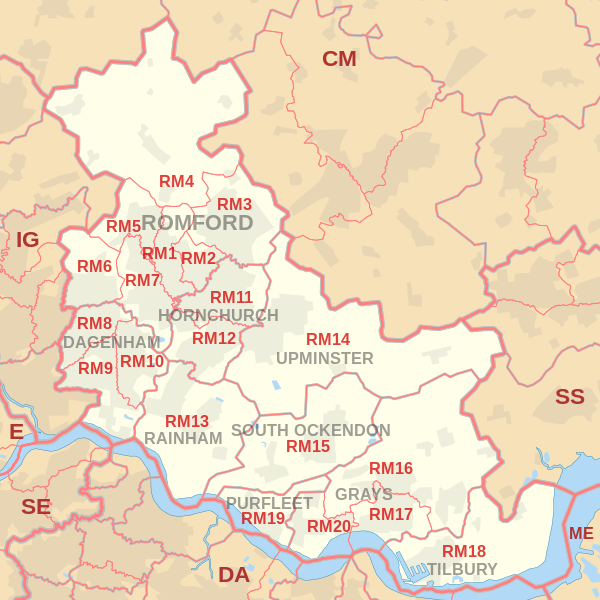
Coverage Area of Postcode RM1 to RM9
 |
| Postcode |
Coverage Area |
Local Authority Area |
| RM1 |
Romford, Rise Park |
Havering |
| RM2 |
Gidea Park, Heath Park |
Havering |
| RM3 |
Harold Wood, Harold Hill, Noak Hill, Harold Park |
Havering |
| RM4 |
Havering-atte-Bower, Abridge, Stapleford Abbotts, Noak Hill, Navestock, Stapleford Tawney, Stapleford Aerodrome |
Havering, Epping Forest, Brentwood |
| RM5 |
Collier Row |
Havering, Redbridge |
| RM6 |
Chadwell Heath, Marks Gate, Little Heath, Goodmayes (north), Hainault (South) |
Barking and Dagenham, Redbridge, Havering |
| RM7 |
Rush Green, Mawneys, Romford |
Havering, Barking and Dagenham |
| RM8 |
Dagenham, Becontree, Becontree Heath, Chadwell Heath |
Barking and Dagenham, Redbridge |
| RM9 |
Dagenham, Becontree Castle Green |
Barking and Dagenham, Redbridge, Havering |
Total Sales By Postcode in 2016
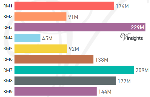
*M represents millions
Average & Median Sales Price By Postcode in 2016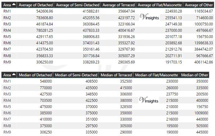
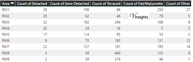
Total Number Of Sales By Postcode in 2016
Multi Year Property Trend Analysis By Postcode
Schools for Postcode Area RM
- RM Postcode Area - RM1, RM2, RM3, RM4, RM5, RM6, RM7, RM8, RM9 School Details
- RM Postcode Area - RM10, RM11, RM12, RM13, RM14, RM15, RM16, RM17, RM18, RM19, RM20 School Details
Posts for Postcode Area RM
All RM Postcode Area Posts
Reference
RM Postcode Area As Per Wikipedia
d508f98e-35ba-475a-9962-dfacd5cfaf68|0|.0|27604f05-86ad-47ef-9e05-950bb762570c
Please click here for the updated version of this post
This Post covers
- Coverage Area of Postcode N20 to N22
- Total Sales By Postcode N20 to N22
- Average & Median Sales Price By Postcode N20 to N22
- Total Number of Sales By Postcode N20 to N22
- Multi Year Property Trend Analysis For Postcode N20 to N22
- Schools for Postcode Area N
- Posts for Postcode Area N
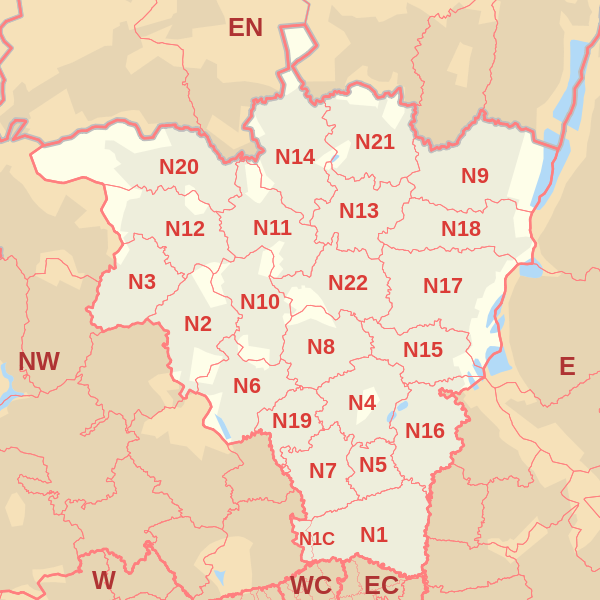
Coverage Area of Postcode N20 to N22
 |
| Postcode |
Coverage Area |
Local Authority Area |
| N20 |
Whetstone, Totteridge, Oakleigh Park |
Barnet |
| N21 |
Winchmore Hill, Bush Hill, Grange Park |
Enfield |
| N22 |
Wood Green, Bounds Green (part), Bowes Park |
Haringey, Enfield |
Total Sales By Postcode in 2016
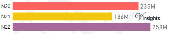
*M represents millions
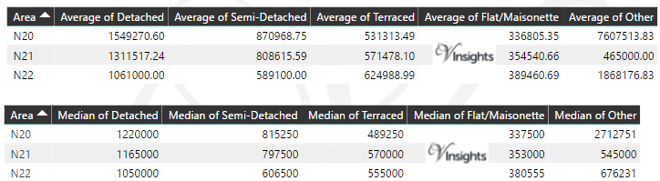
Average & Median Sales Price By Postcode in 2016
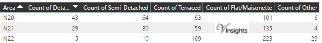
Total Number Of Sales By Postcode in 2016
Multi Year Property Trend Analysis By Postcode
Schools for Postcode Area N
- London N Postcode Area - N1, N1C, N2, N3, N4, N5, N6, N7, N8, N9 School Details
- London N Postcode Area - N10, N11, N12, N13, N14, N15, N16, N17, N18, N19 School Details
- London N Postcode Area - N20, N21, N22 School Details
Posts for Postcode Area N
All N Postcode Area Posts
Reference
N Postcode Area As Per Wikipedia
4670ce5c-e51a-443b-9fdf-a0c15411e549|0|.0|27604f05-86ad-47ef-9e05-950bb762570c
Please click here for the updated version of this post
This Post covers
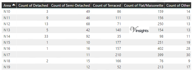
- Coverage Area of Postcode N10 to N19
- Total Sales By Postcode N10 to N19
- Average & Median Sales Price By Postcode N10 to N19
- Total Number of Sales By Postcode N10 to N19
- Multi Year Property Trend Analysis For Postcode N10 to N19
- Schools for Postcode Area N
- Posts for Postcode Area N
Coverage Area of Postcode N10 to N19
 |
| Postcode |
Coverage Area |
Local Authority Area |
| N10 |
Muswell Hill |
Haringey, Barnet |
| N11 |
New Southgate, Friern Barnet, Bounds Green, Arnos Grove (part) |
Enfield, Barnet, Haringey |
| N12 |
North Finchley, Woodside Park |
Barnet |
| N13 |
Palmers Green |
Enfield, Haringey |
| N14 |
Southgate, Oakwood, Arnos Grove (part) |
Enfield, Barnet |
| N15 |
South Tottenham, Harringay (part), West Green, Seven Sisters, Stamford Hill (part) |
Hackney, Haringey |
| N16 |
Stoke Newington, Stamford Hill (part), Shacklewell, Dalston (part), Newington Green (part) |
Islington, Hackney, Harrow |
| N17 |
Tottenham, Wood Green (part) |
Haringey |
| N18 |
Upper Edmonton, Edmonton (part) |
Enfield,Haringey |
| N19 |
Upper Holloway, Archway, Tufnell Park (part) |
Islington, Camden |
Total Sales By Postcode in 2016
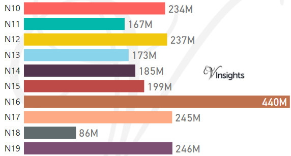
*M represents millions
Average & Median Sales Price By Postcode in 2016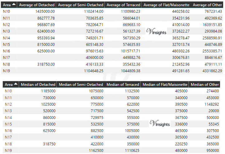
Total Number Of Sales By Postcode in 2016
Multi Year Property Trend Analysis By Postcode
Schools for Postcode Area N
- London N Postcode Area - N1, N1C, N2, N3, N4, N5, N6, N7, N8, N9 School Details
- London N Postcode Area - N10, N11, N12, N13, N14, N15, N16, N17, N18, N19 School Details
- London N Postcode Area - N20, N21, N22 School Details
Posts for Postcode Area N
All N Postcode Area Posts
Reference
N Postcode Area As Per Wikipedia
ba4e458b-b549-4d6d-b25f-ad0049adc8d2|0|.0|27604f05-86ad-47ef-9e05-950bb762570c
Please click here for the updated version of this post
This Post covers
- Coverage Area of Postcode N1 to N9
- Total Sales By Postcode N1 to N9
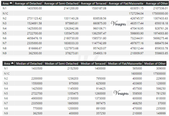
- Average & Median Sales Price By Postcode N1 to N9
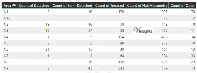
- Total Number of Sales By Postcode N1 to N9
- Multi Year Property Trend Analysis For Postcode N1 to N9
- Schools for Postcode Area N
- Posts for Postcode Area N
Coverage Area of Postcode N1 to N9 Property Sales
| |
| Postcode |
Coverage Area |
Local Authority Area |
| N1 |
Barnsbury (part), Canonbury, Kings Cross, Islington, Pentonville, De Beauvoir Town, Hoxton |
Hackney, Islington, Camden |
| N1C |
Kings Cross Central |
Camden |
| N2 |
East Finchley, Fortis Green, Hampstead Garden Suburb (part) |
Barnet, Haringey |
| N3 |
Finchley, Church End, Finchley Central |
Barnet |
| N4 |
Finsbury Park, Manor House, Harringay (part), Stroud Green (part) |
Haringey, Islington, Hackney |
| N5 |
Highbury, Highbury Fields |
Islington, Hackney |
| N6 |
Highgate, Hampstead Heath (part) |
Camden, Haringey, Islington |
| N7 |
Holloway, Barnsbury (part), Islington (part), Tufnell Park (part) |
Islington, Camden |
| N8 |
Hornsey, Crouch End, Harringay (part) |
Haringey, Islington |
| N9 |
Lower Edmonton, Edmonton (part) |
Enfield |
Total Sales By Postcode in 2016
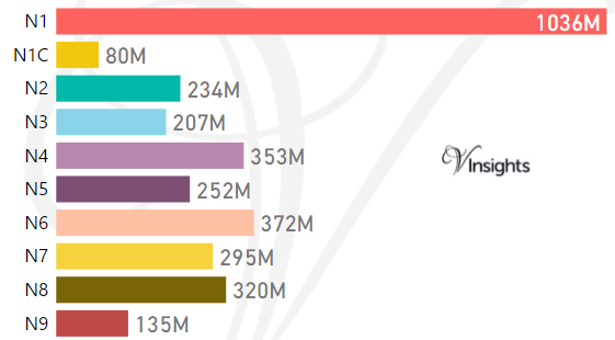
*M represents millions
Average & Median Sales Price By Postcode in 2016
Total Number Of Sales By Postcode in 2016
Multi Year Property Trend Analysis By Postcode
Schools for Postcode Area N
- London N Postcode Area - N1, N1C, N2, N3, N4, N5, N6, N7, N8, N9 School Details
- London N Postcode Area - N10, N11, N12, N13, N14, N15, N16, N17, N18, N19 School Details
- London N Postcode Area - N20, N21, N22 School Details
Posts for Postcode Area N
All N Postcodes Yearly & Trend Analysis Posts
Reference
N Postcode Area As Per Wikipedia
7a56ffd1-b564-4564-88ee-1ebdfda6373b|0|.0|27604f05-86ad-47ef-9e05-950bb762570c