Please click here for the updated version of this post
This Post covers
- Coverage Area of Postcode SM1 to SM7
- Total Sales By Postcode SM1 to SM7
- Average & Median Sales Price By Postcode SM1 to SM7
- Total Number of Sales By Postcode SM1 to SM7
- Multi Year Property Trend Analysis By Postcode SM1 to SM7
- Schools for Postcode Area SM
- Posts for Postcode Area SM
Coverage Area of Postcode SM1 to SM7
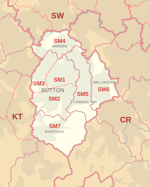 |
| Postcode |
Coverage Area |
Local Authority Area |
| SM1 |
Sutton, Rosehill, Parts of The Wrythe and Carshalton, Benhilton and Erskine Village, the eastern part of Sutton Common |
Sutton |
| SM2 |
Belmont, South Sutton, South Cheam, East Ewell |
Epsom and Ewell, Reigate and Banstead, Sutton |
| SM3 |
The western part of Sutton Common, North Cheam, Stonecot Hill |
Sutton,Merton |
| SM4 |
Morden, Morden Park, Lower Morden, St. Helier (West), Rosehill |
Merton, Sutton |
| SM5 |
Carshalton, Carshalton Beeches, Carshalton on the Hill, The Wrythe, Rosehill, St. Helier (South), Middleton Circle, Little Woodcote |
Sutton |
| SM6 |
Wallington, Beddington, Hackbridge, Roundshaw |
Sutton |
| SM7 |
Banstead, Woodmansterne, Nork, Little Woodcote |
Reigate and Banstead, Sutton |
Total Sales By Postcode in 2016
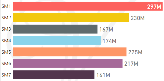
*M represents millions
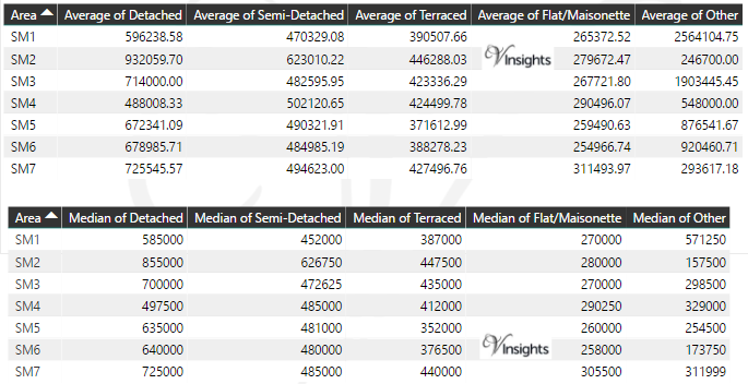
Average & Median Sales Price By Postcode in 2016
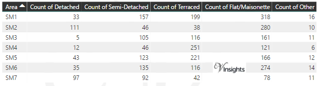
Total Number Of Sales By Postcode in 2016
Multi Year Property Trend Analysis By Postcode
Schools for Postcode Area SM
Posts for Postcode Area SM
All SM Postcode Area Posts

Reference
SM Postcode Area As Per Wikipedia
0104d1ed-8c9d-4d68-b78f-7894a910db4f|0|.0|27604f05-86ad-47ef-9e05-950bb762570c