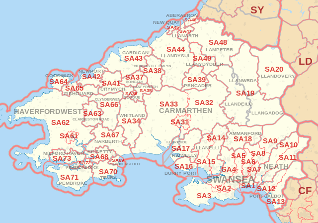
SA Postcode Area - SA20, SA31, SA32, SA33, SA34, SA35, SA36, SA37, SA38, SA39 Property Market 2016

Please click here for the updated version of this post

This Post covers 

  • Coverage Area of Postcode SA20 to SA39
  • Total Sales By Postcode SA20 to SA39
  • Average & Median Sales Price By Postcode SA20 to SA39
  • Spread of Sales Price By Postcode SA20 to SA39
  • Total Number of Sales By Postcode SA20 to SA39
  • Posts for Postcode Area SA


Coverage Area of Postcode SA20 to SA39

Postcode                 Coverage Area          Local Authority Area
SA20 Llandovery Carmarthenshire
SA31 Carmarthen town centre, Cwmffrwd Carmarthenshire
SA32 Nantgaredig, Dryslwyn, Porthyrhyd Carmarthenshire
SA33 Bancyfelin, Pendine, Blaenycoed Carmarthenshire
SA34 Whitland Carmarthenshire
SA35 Llanfyrnach  
SA36 Glogue, Hermon  
SA37 Boncath, Blaenffos  
SA38 Newcastle Emlyn

Carmarthenshire,

Ceredigion

SA39 Pencader  


Total Sales By Postcode 

SA Property Market - Total Sales By Postcode

*M represents Million Pounds


Average & Median Sales Price By Postcode

SA Property Market - Average Sales Price By Postcode

SA Property Market - Median Sales Price By Postcode

                                 *Average and Median Sales Price are in Pounds


Spread of Sales Price By Postcode 

SA Property Market - Spread of Sales Price By Postcode

                     *STDEV is Standard Deviation

For example,

  • Say the average detached property price for postcode XYZ is £300 K and ST. DEV. is 30 K.
  • It means that most detached properties in postcode XYZ (about 68%) has price within one ST. Dev. i.e. the price range is  £270K - £330K.
  • All-most all detached property price (95%) in postcode XYZ lie between two ST. Dev.  i.e. £240 K - £360 K


Total Number Of Sales By Postcode

SA Property Market - Total Number Of Sales By Postcode 


Posts for Postcode Area SA


All Wales Postcode Area Posts

Reference

SA Postcode Area As Per Wikipedia

SA Postcode Area - SA10, SA11, SA12, SA13, SA14, SA15, SA16, SA17, SA18, SA19 Property Market 2016

Please click here for the updated version of this post

This Post covers 

  • Coverage Area of Postcode SA10 to SA19
  • Total Sales By Postcode SA10 to SA19
  • Average & Median Sales Price By Postcode SA10 to SA19
  • Spread of Sales Price By Postcode SA10 to SA19
  • Total Number of Sales By Postcode SA10 to SA19
  • Posts for Postcode Area SA


Coverage Area of Postcode SA10 to SA19

Postcode                 Coverage Area          Local Authority Area
SA10 Aberdulais, Bryncoch, Cadoxton, Caewern, Coed Darcy, Crynant, Jersey Marine, Llandarcy, Neath Abbey, Onllwyn, Seven Sisters, Skewen Neath Port Talbot
SA11 Blaengwrach, Briton Ferry, Cimla, Glynneath, Neath town centre, Resolven, Tonmawr, Tonna Neath Port Talbot
SA12 Aberafan, Aberavon, Baglan, Cwmafan, Port Talbot town centre, Sandfields Neath Port Talbot
SA13 Bryn, Cymmer, Margam, Taibach Neath Port Talbot
SA14 Bynea, Dafen, Llanelli town centre Carmarthenshire
SA15 Felinfoel, Pontyates, Llanelli town centre Carmarthenshire
SA16 Burry Port, Pembrey Carmarthenshire
SA17 Ferryside,Kidwelly, Llansaint, Mynyddygarreg, Carwa Carmarthenshire
SA18 Ammanford town centre, Betws, Garnswllt, Gwaun-Cae-Gurwen, Lower Brynamman, Upper Brynamman Carmarthenshire, Neath Port Talbot, Swansea
SA19 Llandeilo, Llangadog,Llanwrda Carmarthenshire


Total Sales By Postcode 

SA Property Market - Total Sales By Postcode

*M represents Million Pounds


Average & Median Sales Price By Postcode

SA Property Market - Average Sales Price By Postcode

SA Property Market - Median Sales Price By Postcode

*Average and Median Sales Price are in Pounds


Spread of Sales Price By Postcode 

SA Property Market - Spread of Sales Price By Postcode

                                                                                               *STDEV is Standard Deviation

For example,

  • Say the average detached property price for postcode XYZ is £300 K and ST. DEV. is 30 K.
  • It means that most detached properties in postcode XYZ (about 68%) has price within one ST. Dev. i.e. the price range is  £270K - £330K.
  • All-most all detached property price (95%) in postcode XYZ lie between two ST. Dev.  i.e. £240 K - £360 K


Total Number Of Sales By Postcode

SA Property Market - Total Number Of Sales By Postcode


Posts for Postcode Area SA


All Wales Postcode Area Posts

Reference

SA Postcode Area As Per Wikipedia

SA Postcode Area - SA1, SA2, SA3, SA4, SA5, SA6, SA7, SA8, SA9 Property Market 2016

Please click here for the updated version of this post

This Post covers 

  • Coverage Area of Postcode SA1 to SA9
  • Total Sales By Postcode SA1 to SA9
  • Average & Median Sales Price By Postcode SA1 to SA9
  • Spread of Sales Price By Postcode SA1 to SA9
  • Total Number of Sales By Postcode SA1 to SA9
  • Posts for Postcode Area SA


Coverage Area of Postcode SA1 to SA9

Postcode                 Coverage Area          Local Authority Area
SA1 Bonymaen, Copper Quarter, Crymlyn Burrows, Danygraig, Greenhill,Hafod, Jersey Marine,Landore,Maritime Quarter,Mayhill, Mount Pleasant,Pentrechwyth, Port Tennant,St. Thomas, City Centre,Townhill, Waun Wen,Winch Wen,Winch Wen Industrial Estate Swansea
SA2 Brynmill, Cockett, Derwen Fawr, Dunvant, Fairwood, Glanmor, Hendrefoilan, Hendrefoilan Student Village, Ilston, Killay, Sketty, Sketty Park, Singleton Park (University Campus), Tycoch, Uplands, Upper Killay Swansea
SA3 Bishopston, Blackpill, Caswell, Clyne, Langland, Mumbles, Oystermouth, Southgate, South Gower, West Cross Swansea
SA4 Blue Anchor, Gorseinon, Gowerton, Hendy (Carmarthenshire), Loughor, North Gower, Penllergaer, Penclawdd, Pontarddulais, Three Crosses Swansea, Carmarthenshire 
SA5 Blaenymaes, Cwmdu, Cwmdu Industrial Estate, Felindre, Fforestfach, Gendros, Llangyfelach, Llewitha, Manselton, Penlan, Portmead, Tirdeunaw, Waunarlwydd Swansea
SA6 Clase, Cwmrhydyceirw, Clydach, Morriston, Plasmarl, Plasmarl Industrial Estate, Swansea Enterprise Park, Ynystawe, Ynysforgan Swansea
SA7 Birchgrove, Glais, Llansamlet, Swansea Enterprise Park, Talycoppa, Trallwn Swansea
SA8 Alltwen, Cwmtawe, Pontardawe, Rhos, Rhyd-y-fro, Trebanos, Ynysmeudwy Neath Port Talbot
SA9 Abercraf, Cefnbrynbrain, Cwmllynfell, Cwmtwrch, Lower Cwmtwrch, Rhiwfawr, Upper Cwmtwrch, Ystalyfera, Ystradgynlais, Ystradowen Neath Port Talbot
Powys, Carmarthenshire 


Total Sales By Postcode 

SA Property Market - Total Sales By Postcode

*M represents Million Pounds


Average & Median Sales Price By Postcode

SA Property Market - Average Sales Price By Postcode

SA Property Market - Median Sales Price By Postcode

                                                                           *Average and Median Sales Price are in Pounds


Spread of Sales Price By Postcode 

SA Property Market - Spread of Sales Price By Postcode

                                                                                               *STDEV is Standard Deviation

For example,

  • Say the average detached property price for postcode XYZ is £300 K and ST. DEV. is 30 K.
  • It means that most detached properties in postcode XYZ (about 68%) has price within one ST. Dev. i.e. the price range is  £270K - £330K.
  • All-most all detached property price (95%) in postcode XYZ lie between two ST. Dev.  i.e. £240 K - £360 K


Total Number Of Sales By Postcode

SA Property Market - Total Number Of Sales By Postcode


Posts for Postcode Area SA


All Wales Postcode Area Posts

Reference

SA Postcode Area As Per Wikipedia

NP Postcode Area - NP20, NP22, NP23, NP24, NP25, NP26, NP44 Property Market 2016

Please click here for the updated version of this post

This Post covers 

  • Coverage Area of Postcode NP20 to NP44
  • Total Sales By Postcode NP20 to NP44
  • Average & Median Sales Price By Postcode NP20 to NP44
  • Spread of Sales Price By Postcode NP20 to NP44
  • Total Number of Sales By Postcode NP20 to NP44
  • Posts for Postcode Area NP


Coverage Area of Postcode NP20 to NP44

Postcode                 Coverage Area          Local Authority Area
NP20 Western and West Central Newport, including: City centre, Pill, Maesglas, Crindau, Malpas, Bettws Newport
NP22 Tredegar, Rhymney Blaenau Gwent, Caerphilly
NP23 Ebbw Vale, Brynmawr, Cwm Blaenau Gwent
NP24 New Tredegar Caerphilly
NP25 Monmouth, Wyesham, Redbrook, Welsh Newton Monmouthshire, Forest Of Dean, Herefordshire
NP26 Caldicot, Magor, Newport Monmouthshire, Newport
NP44 Cwmbran Torfaen


Total Sales By Postcode 

NP Property Market - Total Sales By Postcode

*M represents Million Pounds


Average & Median Sales Price By Postcode

NP Property Market - Average Sales Price By Postcode

NP Property Market - Median Sales Price By Postcode

*Average and Median Sales Price are in Pounds


Spread of Sales Price By Postcode 
NP Property Market - Spread of Sales Price By Postcode

                        *STDEV is Standard Deviation

For example,

  • Say the average detached property price for postcode XYZ is £300 K and ST. DEV. is 30 K.
  • It means that most detached properties in postcode XYZ (about 68%) has price within one ST. Dev. i.e. the price range is  £270K - £330K.
  • All-most all detached property price (95%) in postcode XYZ lie between two ST. Dev.  i.e. £240 K - £360 K


Total Number Of Sales By Postcode

NP Property Market - Total Number Of Sales By Postcode


Posts for Postcode Area NP


All Wales Postcode Area Posts

Reference

NP Postcode Area As Per Wikipedia

NP Postcode Area - NP10, NP11, NP12, NP13, NP15, NP16, NP18, NP19 Property Market 2016

Please click here for the updated version of this post

This Post covers 

  • Coverage Area of Postcode NP10 to NP19
  • Total Sales By Postcode NP10 to NP19
  • Average & Median Sales Price By Postcode NP10 to NP19
  • Spread of Sales Price By Postcode NP10 to NP19
  • Total Number of Sales By Postcode NP10 to NP19
  • Posts for Postcode Area NP


Coverage Area of Postcode NP10 to NP19

Postcode                 Coverage Area          Local Authority Area
NP10 Western Newport, including Bassaleg, Duffryn, Rogerstone Newport
NP11 North-western Newport, including: Abercarn, Crumlin, Cwmfelinfach, Risca, Ynysddu Caerphilly
NP12 Blackwood, Pontllanfraith, Wyllie Caerphilly
NP13 Abertillery Blaenau Gwent
NP15 Usk, Raglan Monmouthshire
NP16 Chepstow, Sedbury, Beachley Monmouthshire, Forest of Dean
NP18 Eastern Newport, including Caerleon, Langstone, Llanwern, Nash, Llandegveth Underwood Newport, Monmouthshire
NP19 Eastern and East Central Newport, including: Beechwood, Maindee, St. Julians, Ringland Newport


Total Sales By Postcode 

NP Property Market - Total Sales By Postcode

*M represents Million Pounds


Average & Median Sales Price By Postcode

NP Property Market - Average Sales Price By Postcode

NP Property Market - Median Sales Price By Postcode

                                                                           *Average and Median Sales Price are in Pounds


Spread of Sales Price By Postcode 

NP Property Market - Spread of Sales Price By Postcode

                                                                                               *STDEV is Standard Deviation

For example,

  • Say the average detached property price for postcode XYZ is £300 K and ST. DEV. is 30 K.
  • It means that most detached properties in postcode XYZ (about 68%) has price within one ST. Dev. i.e. the price range is  £270K - £330K.
  • All-most all detached property price (95%) in postcode XYZ lie between two ST. Dev.  i.e. £240 K - £360 K


Total Number Of Sales By Postcode

NP Property Market - Total Number Of Sales By Postcode


Posts for Postcode Area NP


All Wales Postcode Area Posts

Reference

NP Postcode Area As Per Wikipedia