Please click here for the updated version of this post
This Post covers
- Coverage Area of Postcode NE1 to NE9
- Total Sales By Postcode NE1 to NE9 in 2016
- Average & Median Sales Price By Postcode NE1 to NE9 in 2016
- Spread of Sales Price By Postcode NE1 to NE9 in 2016
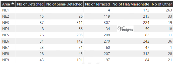
- Total Number of Sales By Postcode NE1 to NE9 in 2016
- Property Posts for Postcode Area NE
- Schools for Postcode Area NE
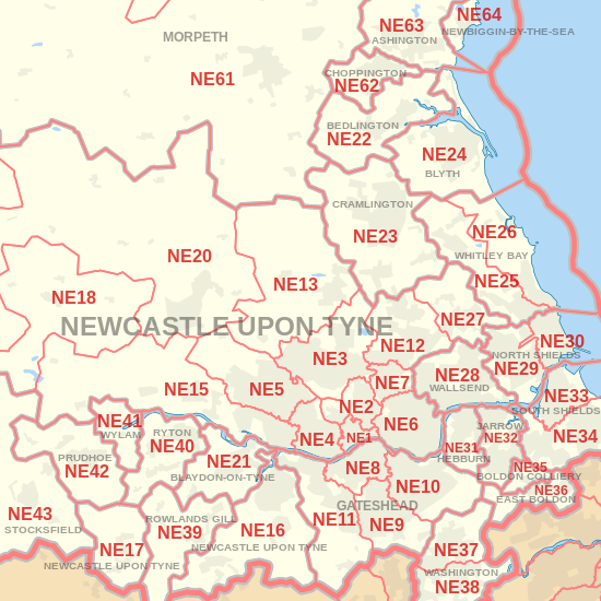
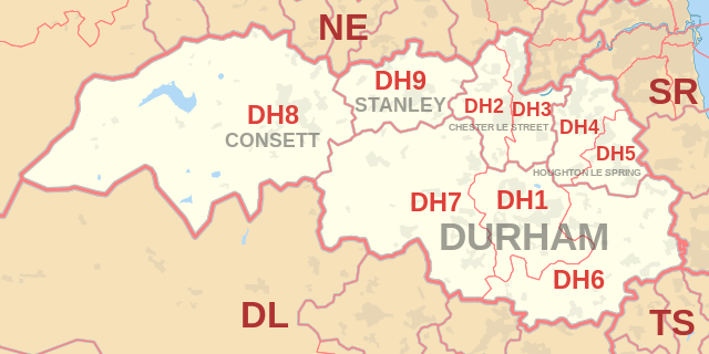
Coverage Area of Postcode NE1 to NE9
|
|
| Postcode |
Coverage Area |
Local Authority Area |
| NE1 |
City Centre |
Newcastle Upon Tyne |
| NE2 |
Jesmond, Spital Tongues |
Newcastle Upon Tyne |
| NE3 |
Gosforth, Fawdon, Kingston Park, Great Park (East) |
Newcastle Upon Tyne |
| NE4 |
Fenham, Westgate, Wingrove |
Newcastle Upon Tyne |
| NE5 |
Westerhope, Newcastle West |
Newcastle Upon Tyne |
| NE6 |
Walker, Byker, Heaton |
Newcastle Upon Tyne |
| NE7 |
High Heaton, Benton |
Newcastle Upon Tyne |
| NE8 |
Gateshead, Bensham |
Gateshead |
| NE9 |
Low Fell, Springwell |
Gateshead, Sunderland |
Total Sales By Postcode in 2016
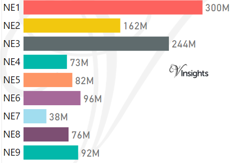
*M represents Million Pounds
Average & Median Sales Price By Postcode in 2016
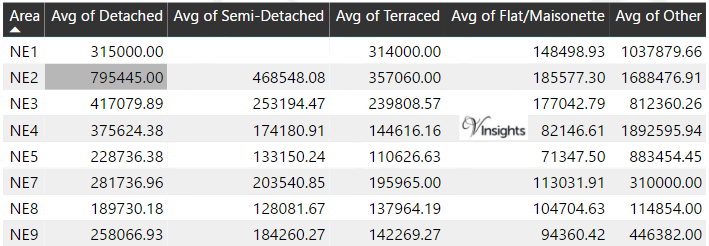
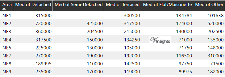
*Average and Median Sales Price are in Pounds
Spread of Sales Price By Postcode in 2016
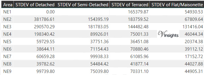
*STDEV is Standard Deviation
For example,
- Say the average detached property price for postcode XYZ is £300 K and ST. DEV. is 30 K.
- It means that most detached properties in postcode XYZ (about 68%) has price within one ST. Dev. i.e. the price range is £270K - £330K.
- All-most all detached property price (95%) in postcode XYZ lie between two ST. Dev. i.e. £240 K - £360 K
Total Number Of Sales By Postcode in 2016
Property Posts for Postcode Area NE
Schools for Postcode Area NE
- NE Postcode Area - NE1, NE2, NE3, NE4, NE5, NE6, NE7, NE8, NE9 School Details
- NE Postcode Area - NE10, NE11, NE12, NE13, NE15, NE16, NE17, NE18, NE19 School Details
- NE Postcode Area - NE20, NE21, NE22, NE23, NE24, NE25, NE26, NE27, NE28, NE29 School Details
- NE Postcode Area - NE30, NE31, NE32, NE33, NE34, NE35, NE36, NE37, NE38, NE39 School Details
- NE Postcode Area - NE40, NE41, NE42, NE43, NE44, NE45, NE46, NE47, NE48, NE49 School Details
- NE Postcode Area - NE61, NE62, NE63, NE64, NE65, NE66, NE67, NE68, NE69, NE70, NE71 School Details
North East England Postcode Area Posts

Reference
NE Postcode Area As Per Wikipedia
6e33795b-508a-40fe-b6f8-84fd21101836|0|.0|27604f05-86ad-47ef-9e05-950bb762570c
Please click here for the updated version of this post
This Post covers
- Coverage Area of Postcode DH1 to DH9
- Total Sales By Postcode DH1 to DH9 in 2016
- Average & Median Sales Price By Postcode DH1 to DH9 in 2016
- Spread of Sales Price By Postcode DH1 to DH9 in 2016
- Total Number of Sales By Postcode DH1 to DH9 in 2016
- Schools for Postcode Area DH
- Property Posts for Postcode Area DH
Coverage Area of Postcode DH1 to DH9
|
| Postcode |
Coverage Area |
Local Authority Area |
| DH1 |
Durham |
County Durham |
| DH2 |
Chester-Le-Street (west of East Coast Main Line), Ouston, Pelton, Birtley (west of East Coast Main Line) |
County Durham, Gateshead |
| DH3 |
Chester-le-Street (east of East Coast Main Line), Great Lumley, Birtley (east of East Coast Main Line) |
County Durham, Gateshead |
| DH4 |
Houghton le Spring (West of A690), Penshaw, Shiney Row |
County Durham, Sunderland |
| DH5 |
Houghton le Spring (East of A690), Hetton-le-Hole |
Sunderland |
| DH6 |
South Hetton, Haswell, Shotton Colliery, Ludworth, Shadforth, Sherburn, Littletown, Kelloe, Coxhoe , Bowburn, Cassop, Pittington, Thornley, Wheatly Hill |
County Durham |
| DH7 |
Brandon, Lanchester, Esh Winning, Burnhope, Langley Park, Sacriston, Ushaw Moor, Brancepeth |
County Durham |
| DH8 |
Consett, Blackhill, Bridgehill, Shotley Bridge, Leadgate, Delves Lane |
County Durham, Northumberland |
| DH9 |
Dipton, Stanley, Annfield Plain |
County Durham |
Total Sales By Postcode in 2016
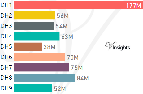
*M represents Million Pounds
Average & Median Sales Price By Postcode in 2016
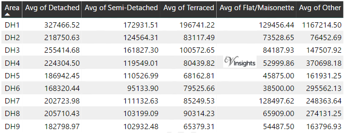
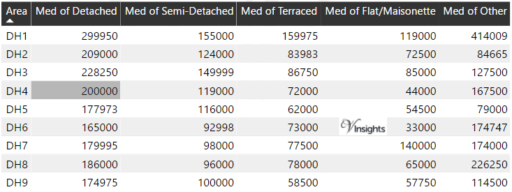
*Average and Median Sales Price are in Pounds
Spread of Sales Price By Postcode in 2016
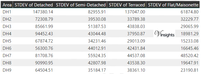
*STDEV is Standard Deviation
For example,
- Say the average detached property price for postcode XYZ is £300 K and ST. DEV. is 30 K.
- It means that most detached properties in postcode XYZ (about 68%) has price within one ST. Dev. i.e. the price range is £270K - £330K.
- All-most all detached property price (95%) in postcode XYZ lie between two ST. Dev. i.e. £240 K - £360 K
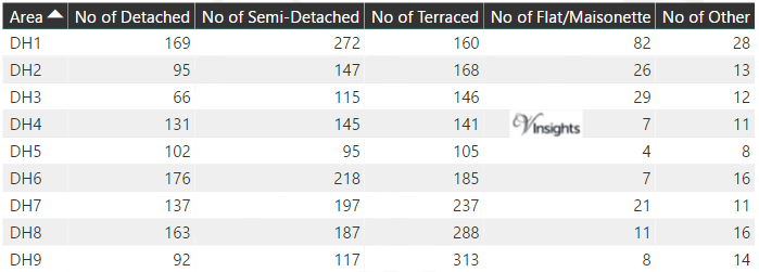
Total Number Of Sales By Postcode in 2016
Schools for Postcode Area DH
Property Posts for Postcode Area DH
North East England Postcode Area Posts
Reference
DH Postcode Area As Per Wikipedia
238dd655-bfd8-4531-9ba8-aa400e11d318|0|.0|27604f05-86ad-47ef-9e05-950bb762570c
Please click here for the updated version of this post
This Post covers
- Coverage Area of Postcode SA70 to SA73
- Total Sales By Postcode SA70 to SA73
- Average & Median Sales Price By Postcode SA70 to SA73
- Spread of Sales Price By Postcode SA70 to SA73
- Total Number of Sales By Postcode SA70 to SA73
- Posts for Postcode Area SA
Coverage Area of Postcode SA70 to SA73
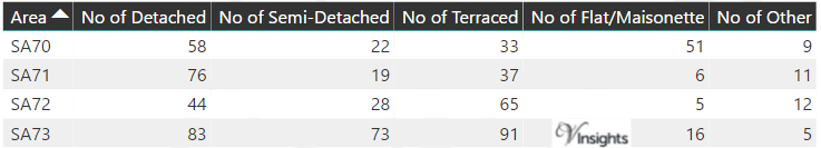
Total Sales By Postcode
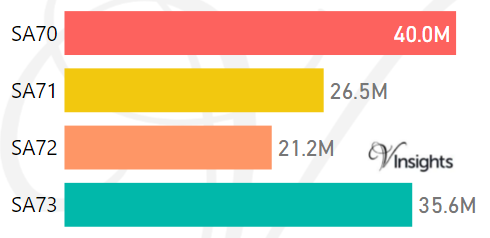
*M represents Million Pounds
Average & Median Sales Price By Postcode
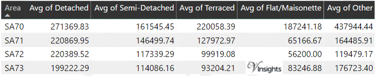
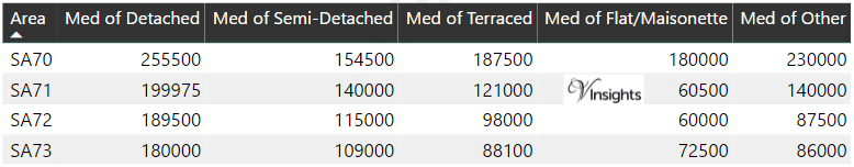
*Average and Median Sales Price are in Pounds
Spread of Sales Price By Postcode
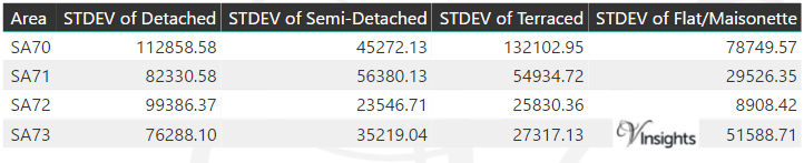
*STDEV is Standard Deviation
For example,
- Say the average detached property price for postcode XYZ is £300 K and ST. DEV. is 30 K.
- It means that most detached properties in postcode XYZ (about 68%) has price within one ST. Dev. i.e. the price range is £270K - £330K.
- All-most all detached property price (95%) in postcode XYZ lie between two ST. Dev. i.e. £240 K - £360 K
Total Number Of Sales By Postcode
Posts for Postcode Area SA
All Wales Postcode Area Posts
Reference
SA Postcode Area As Per Wikipedia
f2adb750-9701-4fd3-9766-fa69676b4d18|0|.0|27604f05-86ad-47ef-9e05-950bb762570c
Please click here for the updated version of this post
This Post covers
- Coverage Area of Postcode SA61 to SA69
- Total Sales By Postcode SA61 to SA69
- Average & Median Sales Price By Postcode SA61 to SA69
- Spread of Sales Price By Postcode SA61 to SA69
- Total Number of Sales By Postcode SA61 to SA69
- Posts for Postcode Area SA
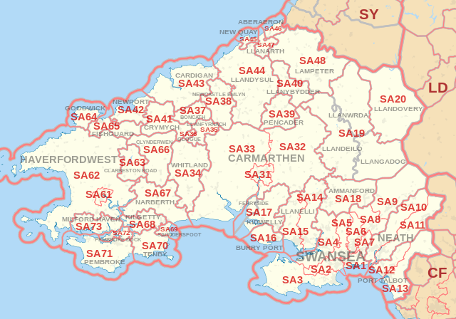
Coverage Area of Postcode SA61 to SA69
|
|
| Postcode |
Coverage Area |
Local Authority Area |
| SA61 |
Haverfordwest town centre, Merlin's Bridge |
Pembrokeshire |
| SA62 |
Johnston |
Pembrokeshire |
| SA63 |
Clarbeston Road |
|
| SA64 |
Goodwick |
|
| SA65 |
Fishguard |
|
| SA66 |
Clynderwen |
|
| SA67 |
Narberth |
|
| SA68 |
Kilgetty |
|
| SA69 |
Saundersfoot |
Pembrokeshire |
Total Sales By Postcode
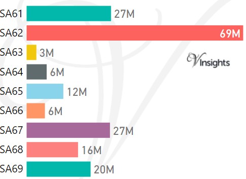
*M represents Million Pounds
Average & Median Sales Price By Postcode
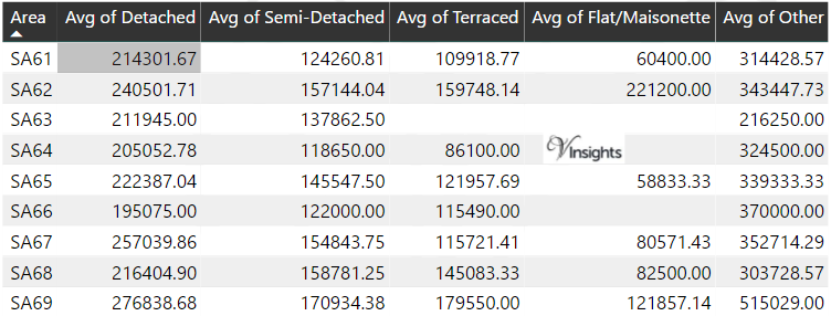
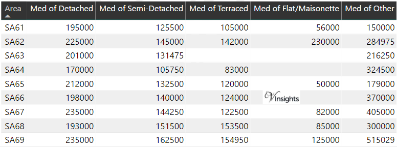
*Average and Median Sales Price are in Pounds
Spread of Sales Price By Postcode
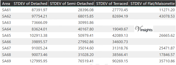
*STDEV is Standard Deviation
For example,
- Say the average detached property price for postcode XYZ is £300 K and ST. DEV. is 30 K.
- It means that most detached properties in postcode XYZ (about 68%) has price within one ST. Dev. i.e. the price range is £270K - £330K.
- All-most all detached property price (95%) in postcode XYZ lie between two ST. Dev. i.e. £240 K - £360 K
Total Number Of Sales By Postcode

Posts for Postcode Area SA
All Wales Postcode Area Posts
Reference
SA Postcode Area As Per Wikipedia
287171c3-d866-4a99-a705-786945cd2e61|0|.0|27604f05-86ad-47ef-9e05-950bb762570c
Please click here for the updated version of this post
This Post covers
- Coverage Area of Postcode SA40 to SA48
- Total Sales By Postcode SA40 to SA48
- Average & Median Sales Price By Postcode SA40 to SA48
- Spread of Sales Price By Postcode SA40 to SA48
- Total Number of Sales By Postcode SA40 to SA48
- Posts for Postcode Area SA
Coverage Area of Postcode SA40 to SA48
|
|
| Postcode |
Coverage Area |
Local Authority Area |
| SA40 |
Llanybydder |
|
| SA41 |
Crymych |
|
| SA42 |
Newport |
|
| SA43 |
Cardigan, New Quay |
Ceredigion |
| SA44 |
Llandysul |
Ceredigion |
| SA45 |
New Quay |
|
| SA46 |
Aberaeron |
Ceredigion |
| SA47 |
Llanarth |
|
| SA48 |
Lampeter |
Ceredigion |
Total Sales By Postcode
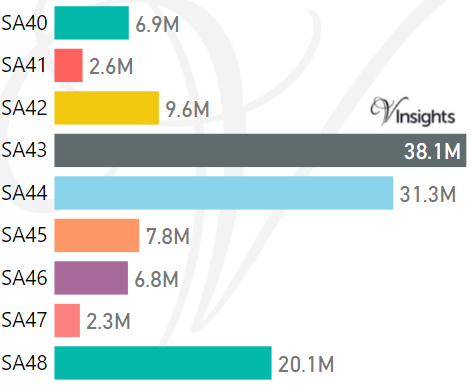
*M represents Million Pounds
Average & Median Sales Price By Postcode
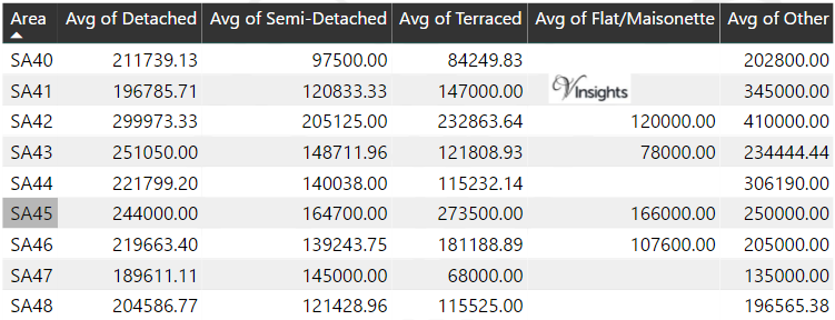
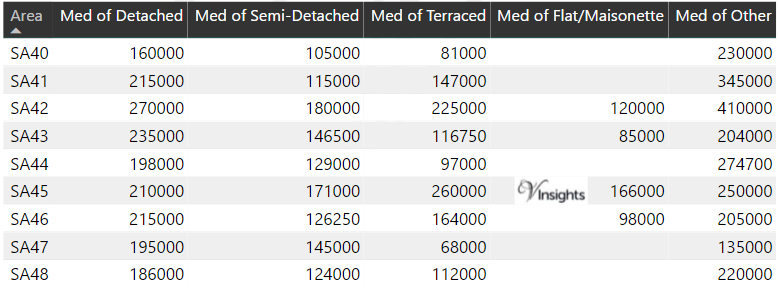
*Average and Median Sales Price are in Pounds
Spread of Sales Price By Postcode
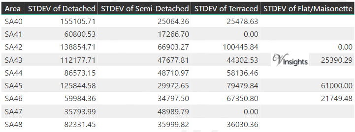
*STDEV is Standard Deviation
For example,
- Say the average detached property price for postcode XYZ is £300 K and ST. DEV. is 30 K.
- It means that most detached properties in postcode XYZ (about 68%) has price within one ST. Dev. i.e. the price range is £270K - £330K.
- All-most all detached property price (95%) in postcode XYZ lie between two ST. Dev. i.e. £240 K - £360 K
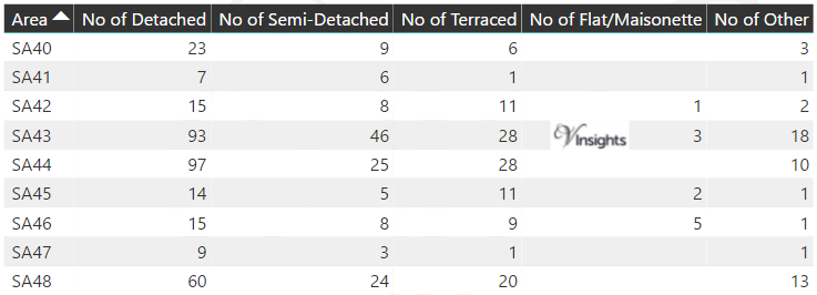
Total Number Of Sales By Postcode
Posts for Postcode Area SA
All Wales Postcode Area Posts
Reference
SA Postcode Area As Per Wikipedia
84d5d57a-94aa-4ac6-b111-24b790dbd1db|0|.0|27604f05-86ad-47ef-9e05-950bb762570c