Please click here for the updated version of this post
This Post covers
- Coverage Area of Postcode CF40 to CF48
- Total Sales By Postcode CF40 to CF48
- Average & Median Sales Price By Postcode CF40 to CF48
- Spread of Sales Price By Postcode CF40 to CF48
- Total Number of Sales By Postcode CF40 to CF48
- Posts for Postcode Area CF
Coverage Area of Postcode CF40 to CF48
|
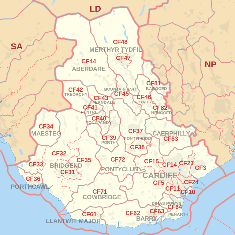
|
| Postcode |
Coverage Area |
Local Authority Area |
| CF40 |
Rhondda Area:TONYPANDY TOWN, TREALAW, PENYGRAIG, Dinas (part of), Williamstown, Cwm Clydach, LLWYNYPIA
Taff-Ely Area:Penrhiwfer
|
Rhondda Cynon Taff |
| CF41 |
Rhondda Area:PENTRE, Ton Pentre, YSTRAD & Gelli |
Rhondda Cynon Taff |
| CF42 |
Rhondda Area:TREORCHY TOWN & Cwmparc & Ynyswen, TREHERBERT & Blaencwm & Blaenrhondda |
Rhondda Cynon Taff |
| CF43 |
Rhondda Area:FERNDALE TOWN & Blaenllechau, TYLORSTOWN & Penrhys, Pontygwaith & Stanleytown, MAERDY |
Rhondda Cynon Taff |
| CF44 |
Cynon Area: ABERDARE TOWN, Cwmaman, ABERAMAN, LLWYDCOED, Cwmbach, HIRWAUN, Penywaun, RHIGOS, Penderyn |
Rhondda Cynon Taff |
| CF45 |
Cynon Area:MOUNTAIN ASH TOWN, ABERCYNON, PENRHIWCEIBER, Ynysboeth |
Rhondda Cynon Taff |
| CF46 |
MERTHYR TYDFIL:TREHARRIS TOWN, Quakers Yard, Bedlinog
CAERPHILLY:Nelson
|
Merthyr Tydfil, Caerphilly |
| CF47 |
Merthyr Tydfil TOWN, Gurnos, Penydarren |
Merthyr Tydfil |
| CF48 |
Cyfarthfa, Pant, Merthyr Vale, Troed-y-rhiw, Vaynor, Pentrebach |
Merthyr Tydfil |
Total Sales By Postcode
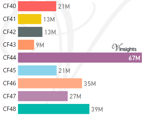
*M represents Million Pounds
Average & Median Sales Price By Postcode
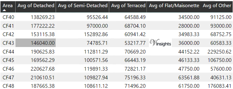
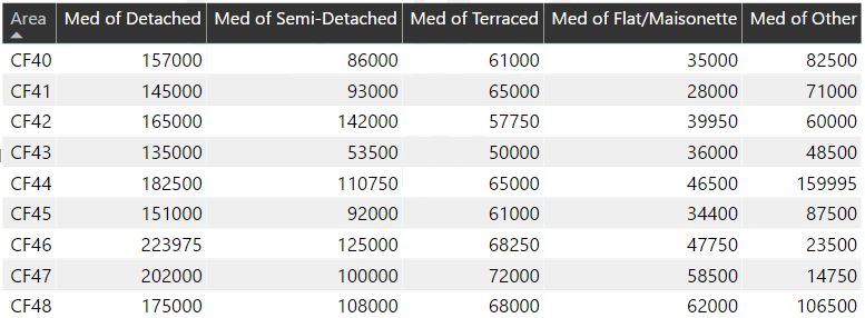
*Average and Median Sales Price are in Pounds
Spread of Sales Price By Postcode
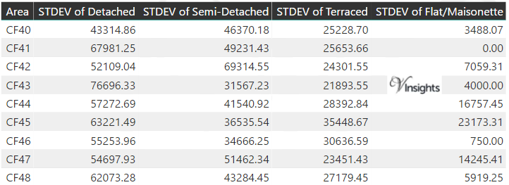
*STDEV is Standard Deviation
For example,
- Say the average detached property price for postcode XYZ is £300 K and ST. DEV. is 30 K.
- It means that most detached properties in postcode XYZ (about 68%) has price within one ST. Dev. i.e. the price range is £270K - £330K.
- All-most all detached property price (95%) in postcode XYZ lie between two ST. Dev. i.e. £240 K - £360 K
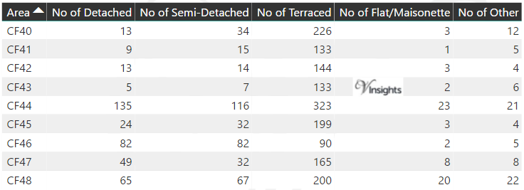
Total Number Of Sales By Postcode
Posts for Postcode Area CF
All Wales Postcode Area Posts

Reference
CF Postcode Area As Per Wikipedia
7cd7f897-5162-4b38-acce-4da6ff7ea128|0|.0|27604f05-86ad-47ef-9e05-950bb762570c
Please click here for the updated version of this post
This Post covers
- Coverage Area of Postcode CF23 to CF39
- Total Sales By Postcode CF23 to CF39
- Average & Median Sales Price By Postcode CF23 to CF39
- Spread of Sales Price By Postcode CF23 to CF39
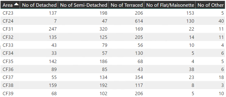
- Total Number of Sales By Postcode CF23 to CF39
- Posts for Postcode Area CF
Coverage Area of Postcode CF23 to CF39
|
|
| Postcode |
Coverage Area |
Local Authority Area |
| CF23 |
CARDIFF NORTH (East):Llanishen, Cyncoed, Pentwyn, Penylan, Pontprennau & Old St Mellons |
Cardiff |
| CF24 |
CARDIFF CENTRAL:CARDIFF CITY CENTRE (part of) & Cathays, Roath & Plasnewydd, Splott, Adamsdown |
Cardiff |
| CF31 |
Bridgend TOWN, Brackla, Coity, Pen-y-fai |
Bridgend |
| CF32 |
BRIDGEND:Cefn Cribwr, Laleston, Merthyr Mawr, Ogmore Vale, Tondu, Sarn, Ynysawdre, St Brides Minor, Pontycymer, Llangeinor, Garw Valley, Blaengarw, Blackmill, Bettws, Aberkenfig
VALE OF GLAMORGAN:St Brides Major
|
Bridgend, Vale of Glamorgan |
| CF33 |
Cornelly, Pyle |
Bridgend |
| CF34 |
MAESTEG TOWN, Llangynwyd, Caerau, Nantyffyllon |
Bridgend |
| CF35 |
BRIDGEND:PENCOED TOWN, Coychurch, Llangan
VALE OF GLAMORGAN:Ewenny
|
Bridgend, Vale of Glamorgan |
| CF36 |
PORTHCAWL TOWN, Nottage, Newton |
Bridgend |
| CF37 |
Pontypridd Community:PONTYPRIDD TOWN including Cilfynydd, Glyncoch, Graig, Treforest, Hopkinstown, Trallwng, Maesycoed, Pwllgwaun, Hawthorn, Rhydfelen, TREHAFOD
Ynysybwl Community:YNYSYBWL & Coed-y-Cwm
|
Rhondda Cynon Taff |
| CF38 |
Llantwit Fardre Community:LLANTWIT FARDRE, CHURCH VILLAGE, Tonteg, Efail Isaf
Llantrisant Community (part of):BEDDAU & Ty Nant
|
Rhondda Cynon Taff |
| CF39 |
Rhondda Area (RCT):PORTH TOWN & Llwyncelyn, CYMMER & Glynfach & Trebanog, YNYSHIR & Wattstown, Dinas (part of)
Taff-Ely Area (RCT):TONYREFAIL TOWN & Coed Ely & Thomastown, GILFACH GOCH
BRIDGEND:Evanstown
|
Rhondda Cynon Taff, Bridgend |
Total Sales By Postcode
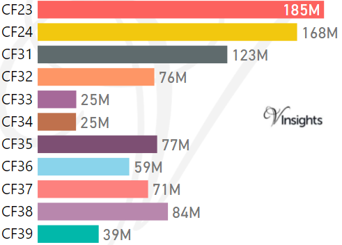
*M represents Million Pounds
Average & Median Sales Price By Postcode
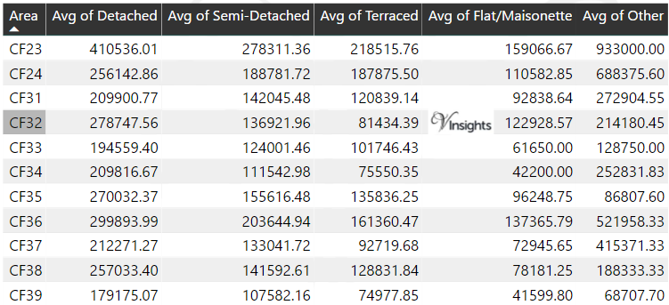
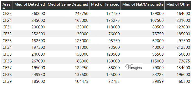
*Average and Median Sales Price are in Pounds
Spread of Sales Price By Postcode
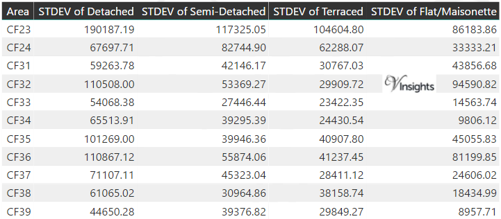
*STDEV is Standard Deviation
For example,
- Say the average detached property price for postcode XYZ is £300 K and ST. DEV. is 30 K.
- It means that most detached properties in postcode XYZ (about 68%) has price within one ST. Dev. i.e. the price range is £270K - £330K.
- All-most all detached property price (95%) in postcode XYZ lie between two ST. Dev. i.e. £240 K - £360 K
Total Number Of Sales By Postcode
Posts for Postcode Area CF
All Wales Postcode Area Posts
Reference
CF Postcode Area As Per Wikipedia
0ec0de15-89ad-4307-9209-434a72d4338d|0|.0|27604f05-86ad-47ef-9e05-950bb762570c
Tags :
CF23 Property Sales ,
CF24 Property Sales ,
CF31 Property Sales ,
CF32 Property Sales ,
CF33 Property Sales ,
CF34 Property Sales ,
CF35 Property Sales ,
CF36 Property Sales ,
CF37 Property Sales ,
CF38 Property Sales ,
CF39 Property Sales
Please click here for the updated version of this post
This Post covers
- Coverage Area of Postcode CF3 to CF15
- Total Sales By Postcode CF3 to CF15
- Average & Median Sales Price By Postcode CF3 to CF15
- Spread of Sales Price By Postcode CF3 to CF15
- Total Number of Sales By Postcode CF3 to CF15
- Other Posts for Postcode Area CF
Coverage Area of Postcode CF3 to CF15
|
|
| Postcode |
Coverage Area |
Local Authority Area |
| CF3 |
CARDIFF SOUTH (East):Rumney & Trowbridge, Llanrumney, St Mellons
NEWPORT WEST: Castleton, Marshfield |
Cardiff, Newport |
| CF5 |
CARDIFF WEST (South):Ely, Caerau, St Fagans, Culverhouse Cross, Canton & Leckwith, Fairwater, Danescourt, Llandaff, Riverside
VALE OF GLAMORGAN:Wenvoe, Peterston Super Ely, St Georges Super Ely, Michaelston
|
Cardiff, Vale of Glamorgan |
| CF10 |
CARDIFF CENTRAL / CARDIFF SOUTH:CARDIFF CITY CENTRE (part of), Grangetown, CARDIFF BAY (part of) & Butetown |
Cardiff |
| CF11 |
CARDIFF CENTRAL / CARDIFF SOUTH:CARDIFF CITY CENTRE (part of), Canton, CARDIFF BAY (part of), Grangetown |
Cardiff |
| CF14 |
CARDIFF NORTH (West):Birchgrove, Whitchurch, Thornhill & Lisvane, Rhiwbina & Pantmawr, Gabalfa, Heath, Llandaff North, Llanishen |
Cardiff |
| CF15 |
CARDIFF WEST (North):Pentyrch & Gwaelod-y-Garth & Creigiau, Radyr & Morganstown, Tongwynlais
Rhondda Cynon Taff:TAFFS WELL & Nantgarw
Caerphilly:Groeswen
|
Cardiff, Rhondda Cynon Taff, Caerphilly |
Total Sales By Postcode
*M represents Million Pounds
Average & Median Sales Price By Postcode
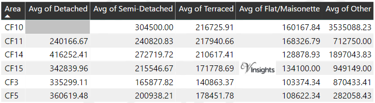
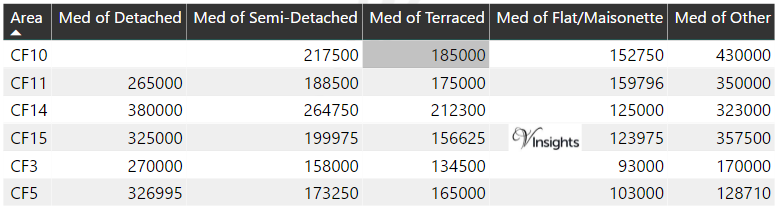
*Average and Median Sales Price are in Pounds
Spread of Sales Price By Postcode
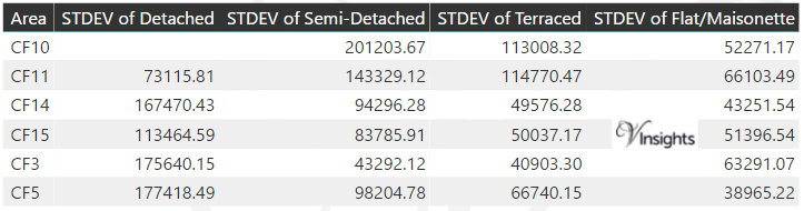
*STDEV is Standard Deviation
For example,
- Say the average detached property price for postcode XYZ is £300 K and ST. DEV. is 30 K.
- It means that most detached properties in postcode XYZ (about 68%) has price within one ST. Dev. i.e. the price range is £270K - £330K.
- All-most all detached property price (95%) in postcode XYZ lie between two ST. Dev. i.e. £240 K - £360 K
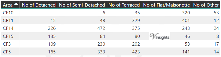
Total Number Of Sales By Postcode
Posts for Postcode Area CF
All Wales Postcode Area Posts
Reference
CF Postcode Area As Per Wikipedia
ca1b9e64-1a2d-44cd-bb83-b3d547fb9ef4|0|.0|27604f05-86ad-47ef-9e05-950bb762570c
Please click here for the updated version of this post
This Post covers
- Coverage Area of Postcode YO41 to YO90
- Total Sales By Postcode YO41 to YO90
- Average & Median Sales Price By Postcode YO41 to YO90
- Spread of Sales Price By Postcode YO41 to YO90
- Total Number of Sales By Postcode YO41 to YO90
- Property Posts for Postcode Area YO
- Schools for Postcode Area YO
Coverage Area of Postcode YO41 to YO90
|
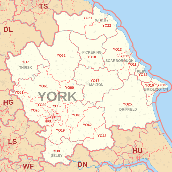
|
| Postcode |
Coverage Area |
Local Authority Area |
| YO41 |
Elvington, Full Sutton, Stamford Bridge, Sutton upon Derwent, Wilberfoss |
|
| YO42 |
Pocklington, Barmby Moor, Melbourne, Seaton Ross |
East Riding Of Yorkshire |
| YO43 |
Market Weighton, Holme-on-Spalding-Moor |
East Riding Of Yorkshire |
| YO51 |
Boroughbridge |
North Yorkshire County Council |
| YO60 |
Sheriff Hutton |
|
| YO61 |
Easingwold |
North Yorkshire County Council |
| YO62 |
Helmsley, Kirkbymoorside, Nawton |
North Yorkshire County Council |
| YO90 |
Rougier St, Wellington Row |
|
Total Sales By Postcode
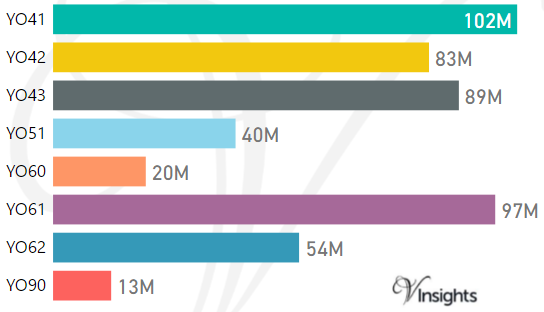
*M represents Million Pounds
Average & Median Sales Price By Postcode
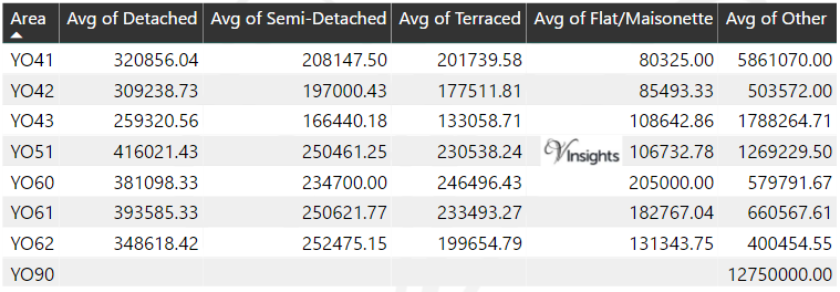
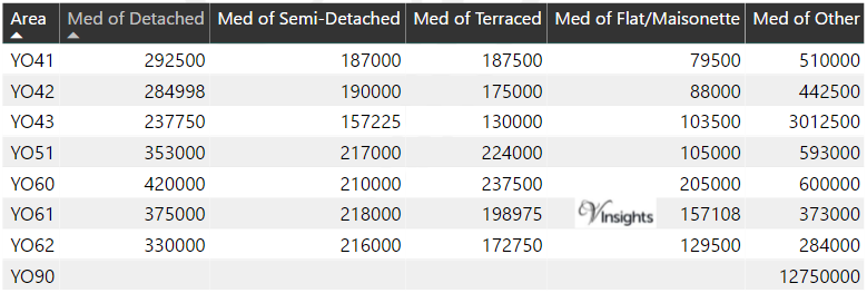
*Average and Median Sales Price are in Pounds
Spread of Sales Price By Postcode
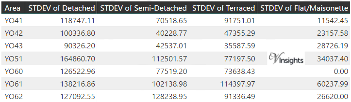
*STDEV is Standard Deviation
For example,
- Say the average detached property price for postcode XYZ is £300 K and ST. DEV. is 30 K.
- It means that most detached properties in postcode XYZ (about 68%) has price within one ST. Dev. i.e. the price range is £270K - £330K.
- All-most all detached property price (95%) in postcode XYZ lie between two ST. Dev. i.e. £240 K - £360 K
Total Number Of Sales By Postcode

Property Posts for Postcode Area YO
Schools for Postcode Area YO
- YO Postcode Area - YO1, YO7, YO8, Y10, YO11, YO12, YO13, YO14 School Details
- YO Postcode Area - YO15, YO16, YO17, YO18, YO19, YO21, YO22 School Details
- YO Postcode Area - YO23, YO24, YO25, YO26, YO30, YO31, YO32 School Details
- YO Postcode Area - YO41, YO42, YO43, YO51, YO60, YO61, YO62, YO90 School Details
All Yorkshire & Humber Postcode Area Posts
Reference
YO Postcode Area As Per Wikipedia
b3afc6f1-5778-44ab-a882-9bc10430aa20|0|.0|27604f05-86ad-47ef-9e05-950bb762570c
Please click here for the updated version of this post
This Post covers
- Coverage Area of Postcode YO23 to YO32
- Total Sales By Postcode YO23 to YO32
- Average & Median Sales Price By Postcode YO23 to YO32
- Spread of Sales Price By Postcode YO23 to YO32
- Total Number of Sales By Postcode YO23 to YO32
- Other Property Posts for Postcode Area YO
- Schools for Postcode Area YO
Coverage Area of Postcode YO23 to YO32
|
|
| Postcode |
Coverage Area |
Local Authority Area |
| YO23 |
South Bank, Bishopthorpe, Copmanthorpe, Rufforth |
City of York Council |
| YO24 |
Acomb, Dringhouses, Woodthorpe |
City of York Council |
| YO25 |
Driffield |
East Riding Of Yorkshire |
| YO26 |
Acomb, Leeman Road Area, Upper Poppleton, Nether Poppleton, Green Hammerton |
City of York Council |
| YO30 |
Bootham, Clifton, Skelton, Linton-on-Ouse |
City of York Council |
| YO31 |
Heworth, Huntington (South), The Groves, Layerthorpe |
City of York Council |
| YO32 |
Haxby, Huntington (North), Wigginton, New Earswick, Stockton-on-the-Forest, Strensall |
City of York Council |
Total Sales By Postcode
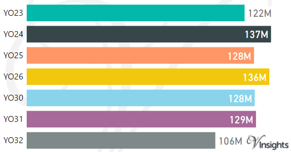
*M represents Million Pounds
Average & Median Sales Price By Postcode
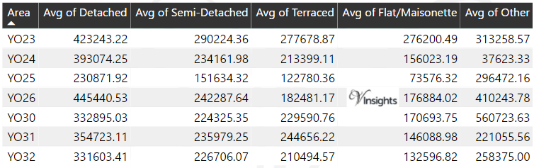
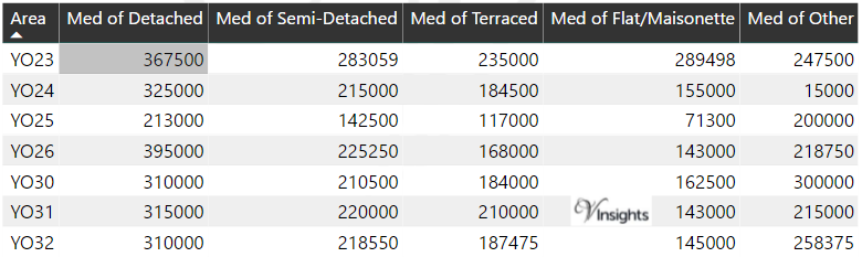
*Average and Median Sales Price are in Pounds
Spread of Sales Price By Postcode
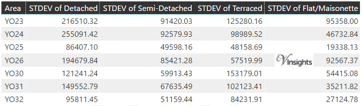
*STDEV is Standard Deviation
For example,
- Say the average detached property price for postcode XYZ is £300 K and ST. DEV. is 30 K.
- It means that most detached properties in postcode XYZ (about 68%) has price within one ST. Dev. i.e. the price range is £270K - £330K.
- All-most all detached property price (95%) in postcode XYZ lie between two ST. Dev. i.e. £240 K - £360 K
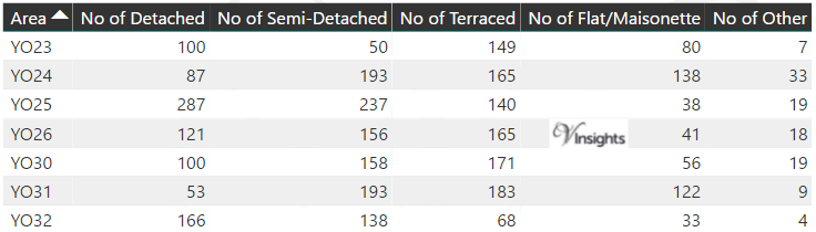
Total Number Of Sales By Postcode
Property Posts for Postcode Area YO
Schools for Postcode Area YO
- YO Postcode Area - YO1, YO7, YO8, Y10, YO11, YO12, YO13, YO14 School Details
- YO Postcode Area - YO15, YO16, YO17, YO18, YO19, YO21, YO22 School Details
- YO Postcode Area - YO23, YO24, YO25, YO26, YO30, YO31, YO32 School Details
- YO Postcode Area - YO41, YO42, YO43, YO51, YO60, YO61, YO62, YO90 School Details
All Yorkshire & Humber Postcode Area Posts
Reference
YO Postcode Area As Per Wikipedia
fa620b5c-371e-4cb1-8df0-59e69743c27c|0|.0|27604f05-86ad-47ef-9e05-950bb762570c