Please click here for the updated version of this post
This Post covers
- Coverage Area of Postcode W1B to W1W
- Total Sales By Postcode W1B to W1W
- Average & Median Sales Price By Postcode W1B to W1W
- Total Number of Sales By Postcode W1B to W1W
- Multi Year Property Trend Analysis By Postcode W1B to W1W
- Schools for Postcode Area W
- Posts for Postcode Area W
Coverage Area of Postcode W1B to W1W
Total Sales By Postcode in 2016
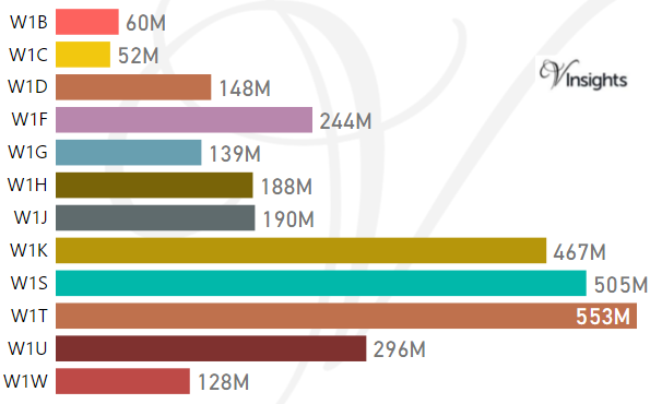
The Total Sales by the Postcodes are:
- W1B £60 millions, W1C £52 millions , W1D £148 millions, W1F £244 millions
- W1G £139 millions, W1H £188 millions , W1J £190 millions, W1K £467 millions
- W1S £505 millions, W1T £553 millions , W1U £296 millions, W1W £128 millions
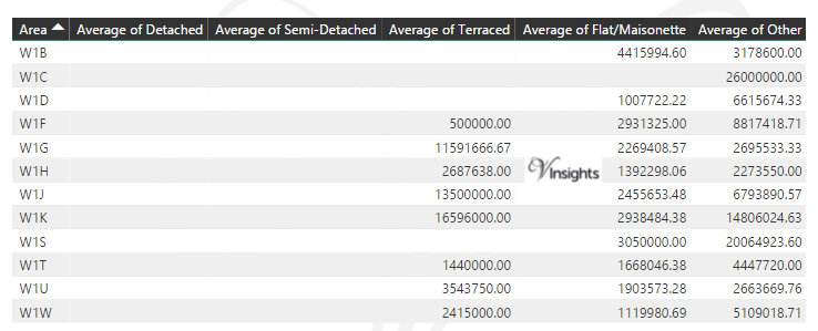
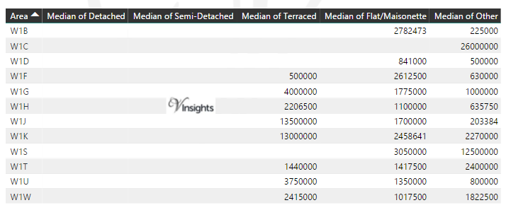
Average & Median Sales Price By Postcode in 2016
Total Number Of Sales By Postcode in 2016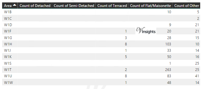
Multi Year Property Trend Analysis By Postcode
Schools for Postcode Area W
- London W Postcode Area - W1B, W1C, W1D, W1F, W1G, W1H, W1J, W1K, W1S, W1T, W1U, W1W School Details
- London W Postcode Area - W2, W3, W4, W5, W6, W7, W8, W9 School Details
- London W Postcode Area - W10, W11, W12, W13, W14 School Details
Posts for Postcode Area W
 All Postcode Area Posts
Reference
W Postcode Area As Per Wikipedia
a8046eb2-cf8b-45e7-988a-f2955861273f|0|.0|27604f05-86ad-47ef-9e05-950bb762570c
Tags :
W1B Property Sales ,
W1C Property Sales ,
W1D Property Sales ,
W1F Property Sales ,
W1G Property Sales ,
W1H Property Sales ,
W1J Property Sales ,
W1K Property Sales ,
W1S Property Sales ,
W1T Property Sales ,
W1U Property Sales ,
W1W Property Sales
Please click here for the updated version of this post
This Post covers
- Coverage Area of Postcode UB7 to UB11
- Total Sales By Postcode UB7 to UB11
- Average & Median Sales Price By Postcode UB7 to UB11
- Total Number of Sales By Postcode UB7 to UB11
- Multi Year Property Trend Analysis By Postcode UB1 to UB6
- Schools for Postcode Area UB
- Posts for Postcode Area UB
Coverage Area of Postcode UB7 to UB11
Total Sales By Postcode UB7 to UB11 in 2016
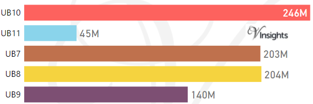
The Total Sales by the Postcodes are:
- UB10 £246 millions, UB11 £45 millions
- UB7 £203 millions, UB8 £204 millions , UB9 £140 millions
Average & Median Sales Price By Postcode in 2016
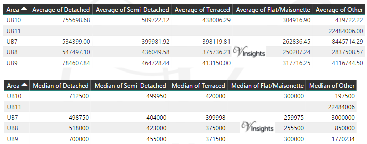
Total Number Of Sales By Postcode in 2016
Multi Year Property Trend Analysis By Postcode
Schools for Postcode Area UB
Posts for Postcode Area UB
All Postcode Area Posts
Reference
UB Postcode Area As Per Wikipedia
7f9c0f86-f4b2-40ac-ba60-972b0ca59a4f|0|.0|27604f05-86ad-47ef-9e05-950bb762570c
Please click here for the updated version of this post
This Post covers
- Coverage Area of Postcode UB1 to UB6
- Total Sales By Postcode UB1 to UB6
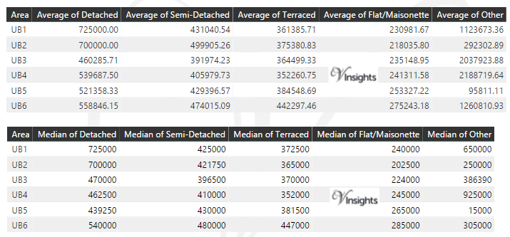
- Average & Median Sales Price By Postcode UB1 to UB6
- Total Number of Sales By Postcode UB1 to UB6
- Multi Year Property Trend Analysis By Postcode UB1 to UB6
- Schools for Postcode Area UB
- Posts for Postcode Area UB
Coverage Area of Postcode UB1 to UB6
Total Sales By Postcode UB1 to UB6 in 2016
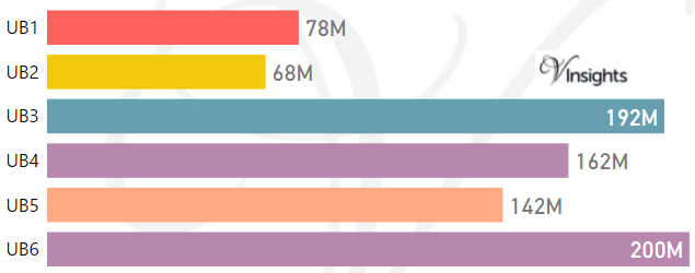
The Total Sales by the Postcodes are:
- UB1 £78 millions, UB2 £68 millions , UB3 £192 millions
- UB4 £162 millions, UB5 £142 millions , UB6 £200 millions
Average & Median Sales Price By Postcode in 2016
Total Number Of Sales By Postcode in 2016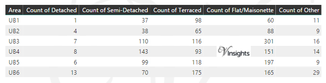
Multi Year Property Trend Analysis By Postcode
Schools for Postcode Area UB
Posts for Postcode Area UB
All Postcode Area Posts
Reference
UB Postcode Area As Per Wikipedia
9607f20d-d039-47bc-99c2-1a9e6057c8c6|0|.0|27604f05-86ad-47ef-9e05-950bb762570c
Please click here for the updated version of this post
This Post covers
- Coverage Area of Postcode RG26 to RG45
- Total Sales By Postcode RG26 to RG45
- Average & Median Sales Price By Postcode RG26 to RG45
- Total Number of Sales By Postcode RG26 to RG45
- Multi Year Property Trend Analysis By Postcode RG26 to RG45
- Schools for Postcode Area RG
- Posts for Postcode Area RG
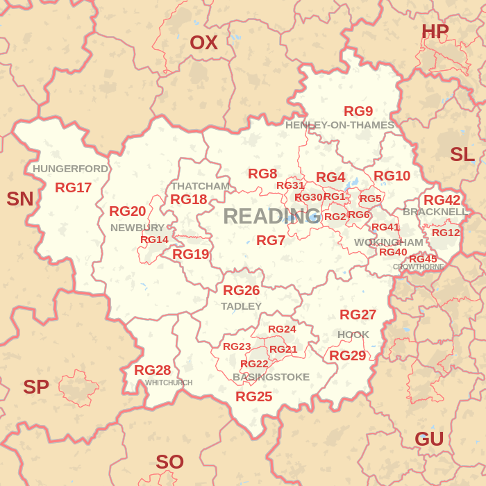
Coverage Area of Postcode RG26 to RG45
 |
| Postcode |
Coverage Area |
Local Authority Area |
| RG26 |
Baughurst, Bramley, Brimpton Common, Hannington, Pamber End, Pamber Heath, Tadley |
Basingstoke and Deane, West Berkshire |
| RG27 |
Hook, Sherfield-on-Loddon, Stratfield Turgis, Turgis Green |
Basingstoke and Deane, Hart |
| RG28 |
Laverstoke, Litchfield, Hurstbourne Priors, Whitchurch (Hants) |
Basingstoke and Deane, Test Valley |
| RG29 |
Long Sutton, Odiham, North Warnborough, South Warnborough |
Hart |
| RG30 |
Tilehurst, Prospect Park, Purley-on-Thames, Reading (west), Southcote |
Reading, West Berkshire |
| RG31 |
Calcot Row, Tilehurst |
Reading, West Berkshire |
| RG40 |
Wokingham (east and town centre), Finchampstead, Barkham (south), Wick Hill |
Wokingham, Bracknell Forest |
| RG41 |
Wokingham (west), Winnersh, Woosehill, Barkham (north), Sindlesham, Emmbrook, Eastheath |
Wokingham |
| RG42 |
Bracknell (north), Binfield, Warfield, Newell Green, Popeswood, Priestwood, Winkfield Row, Jealott's Hill |
Bracknell Forest |
| RG45 |
Crowthorne, Ravenswood |
Bracknell Forest, Wokingham |
Total Sales By Postcode in 2016
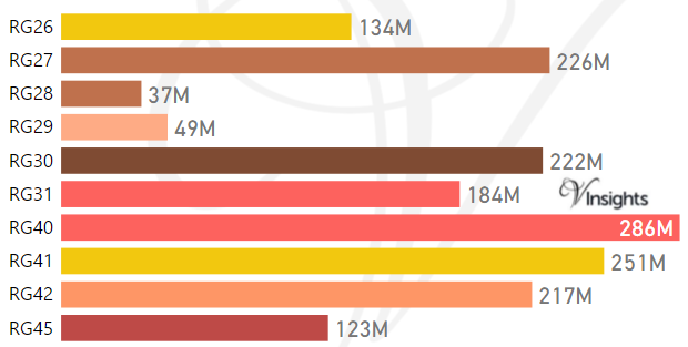
The Total Sales by the Postcodes are:
- RG26 £134 millions, RG27 £226 millions, RG28 £37 millions
- RG29 £49 millions, RG30 £222 millions, RG31 £184 millions
- RG40 £286 millions, RG40 £251 millions, RG42 £217 millions,
- RG45 £123 millions
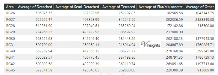
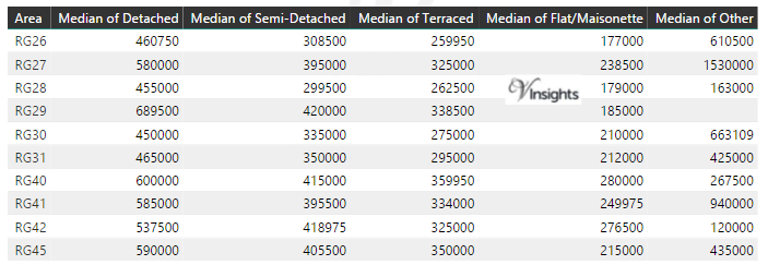
Average & Median Sales Price By Postcode in 2016
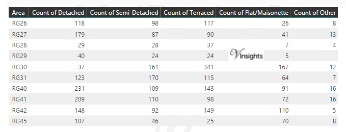
Total Number Of Sales By Postcode in 2016
Multi Year Property Trend Analysis By Postcode
Schools for Postcode Area RG
- RG Postcode Area - RG1, RG2, RG4, RG5, RG6, RG7, RG8, RG9 School Details
- RG Postcode Area - RG10, RG12, RG14, RG17, RG18, RG19, RG20, RG21, RG22, RG23,RG24, RG25 School Details
- RG Postcode Area - RG26, RG27, RG28, RG29, RG30, RG31, RG40, RG41, RG42, RG45 School Details
Posts for Postcode Area RG
All RG Postcodes Yearly & Trend Analysis Posts
Reference
RG Postcode Area As Per Wikipedia
efbd46b5-5779-4203-9619-e3cd14b9eb40|0|.0|27604f05-86ad-47ef-9e05-950bb762570c
Please click here for the updated version of this post
This Post covers
- Coverage Area of Postcode RG10 to RG25
- Total Sales By Postcode RG10 to RG25
- Average & Median Sales Price By Postcode RG10 to RG25
- Total Number of Sales By Postcode RG10 to RG25
- Multi Year Property Trend Analysis By Postcode RG10 to RG25
- Schools for Postcode Area RG
- Posts for Postcode Area RG
Coverage Area of Postcode RG10 to RG25
|
| Postcode |
Coverage Area |
Local Authority Area |
| RG10 |
Charvil, Hurst, Ruscombe, Twyford, Wargrave, Waltham St Lawrence |
Wokingham, Windsor and Maidenhead |
| RG12 |
Bracknell (south and town centre), Easthampstead, Bullbrook |
Bracknell Forest |
| RG14 |
Newbury (whole town area) |
West Berkshire |
| RG17 |
Chilton Foliat, Eastbury, Eddington, Kintbury, Hungerford, Inkpen, Lambourn, North Wessex Downs AONB area |
West Berkshire, Wiltshire |
| RG18 |
Hampstead Norreys, Hermitage, Thatcham (north), Yattendon |
West Berkshire |
| RG19 |
Ashford Hill with Headley, Bishop's Green, Greenham, Thatcham (south) |
West Berkshire, Basingstoke and Deane |
| RG20 |
Ashmansworth, Chieveley, Compton, Ecchinswell, Leckhampstead, Highclere, Kingsclere, Sydmonton |
West Berkshire, Basingstoke and Deane |
| RG21 |
Town Centre, Eastrop, Black Dam, Oakridge, South View |
Basingstoke and Deane |
| RG22 |
South Ham, Brighton Hill, Kempshott, Buckskin, Beggarwood |
Basingstoke and Deane |
| RG23 |
Winklebury, Rooksdown, Oakley |
Basingstoke and Deane |
| RG24 |
Popley, Chineham, Sherborne St John |
Basingstoke and Deane |
| RG25 |
Cliddesden, Dummer, Overton, North Waltham |
Basingstoke and Deane |
Total Sales By Postcode in 2016
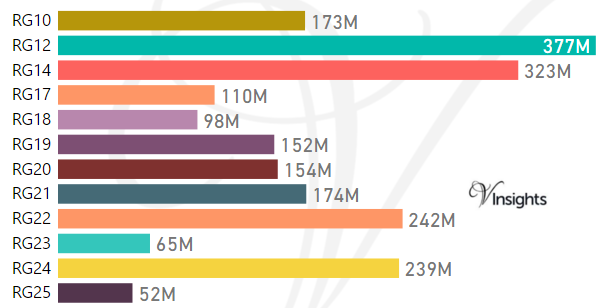
The Total Sales by the Postcodes are:
- RG10 £173 millions, RG12 £377 millions, RG14 £323 millions
- RG17 £110 millions, RG18 £98 millions, RG19 £152 millions
- RG20 £154 millions, RG21 £174 millions, RG22 £242 millions
- RG23 £65 millions, RG24 £239 millions, RG25 £52 millions
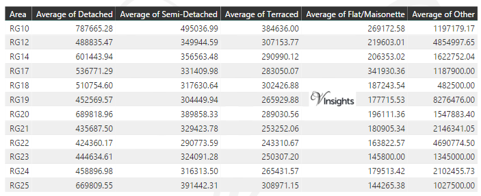
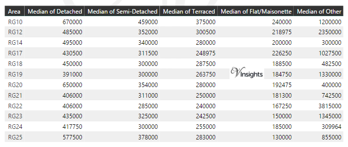
Average & Median Sales Price By Postcode in 2016
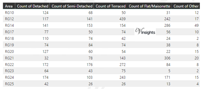
Total Number Of Sales By Postcode in 2016
Multi Year Property Trend Analysis By Postcode
Schools for Postcode Area RG
- RG Postcode Area - RG1, RG2, RG4, RG5, RG6, RG7, RG8, RG9 School Details
- RG Postcode Area - RG10, RG12, RG14, RG17, RG18, RG19, RG20, RG21, RG22, RG23,RG24, RG25 School Details
- RG Postcode Area - RG26, RG27, RG28, RG29, RG30, RG31, RG40, RG41, RG42, RG45 School Details
Posts for Postcode Area RG
All RG Postcodes Yearly & Trend Analysis Posts
Reference
RG Postcode Area As Per Wikipedia
f88ffbd2-8515-4615-b18f-04bb97b5f529|0|.0|27604f05-86ad-47ef-9e05-950bb762570c
Tags :
RG10 Property sales ,
RG12 Property sales ,
RG14 Property sales ,
RG17 Property sales ,
RG18 Property sales ,
RG19 Property sales ,
RG20 Property sales ,
RG21 Property sales ,
RG22 Property sales ,
RG23 Property sales ,
RG24 Property sales ,
RG25 Property sales