Please click here for the updated version of this post
This Post covers
- Coverage Area of Postcode YO15 to YO22
- Total Sales By Postcode YO15 to YO22
- Average & Median Sales Price By Postcode YO15 to YO22
- Spread of Sales Price By Postcode YO15 to YO22
- Total Number of Sales By Postcode YO15 to YO22
- Other Property Posts for Postcode Area YO
- Schools for Postcode Area YO
Coverage Area of Postcode YO15 to YO22
|
|
| Postcode |
Coverage Area |
Local Authority Area |
| YO15 |
Bridlington, Bempton, Buckton, Carnaby, Flamborough, Fraisthorpe, Sewerby, Wilsthorpe |
East Riding Of Yorkshire |
| YO16 |
Bridlington, Bempton, Bessingby, Boynton, Buckton, Carnaby, Grindale, Sewerby |
East Riding Of Yorkshire |
| YO17 |
Norton |
North Yorkshire County Council |
| YO18 |
Pickering, Thornton-le-Dale |
North Yorkshire County Council |
| YO19 |
Dunnington, Escrick, Wheldrake, Murton, Riccall, Stillingfleet, Warthill |
|
| YO21 |
Whitby, Westerdale |
North Yorkshire County Council |
| YO22 |
Robin Hood's Bay |
North Yorkshire County Council |
Total Sales By Postcode

*M represents Million Pounds
Average & Median Sales Price By Postcode


*Average and Median Sales Price are in Pounds
Spread of Sales Price By Postcode

*STDEV is Standard Deviation
For example,
- Say the average detached property price for postcode XYZ is £300 K and ST. DEV. is 30 K.
- It means that most detached properties in postcode XYZ (about 68%) has price within one ST. Dev. i.e. the price range is £270K - £330K.
- All-most all detached property price (95%) in postcode XYZ lie between two ST. Dev. i.e. £240 K - £360 K
Total Number Of Sales By Postcode

Property Posts for Postcode Area YO
Schools for Postcode Area YO
- YO Postcode Area - YO1, YO7, YO8, Y10, YO11, YO12, YO13, YO14 School Details
- YO Postcode Area - YO15, YO16, YO17, YO18, YO19, YO21, YO22 School Details
- YO Postcode Area - YO23, YO24, YO25, YO26, YO30, YO31, YO32 School Details
- YO Postcode Area - YO41, YO42, YO43, YO51, YO60, YO61, YO62, YO90 School Details
All Yorkshire & Humber Postcode Area Posts

Reference
YO Postcode Area As Per Wikipedia
c2012579-1969-4b33-8040-d2cd374d140a|0|.0|27604f05-86ad-47ef-9e05-950bb762570c
Please click here for the updated version of this post
This Post covers
- Coverage Area of Postcode YO1 to YO14
- Total Sales By Postcode YO1 to YO14
- Average & Median Sales Price By Postcode YO1 to YO14
- Spread of Sales Price By Postcode YO1 to YO14
- Total Number of Sales By Postcode YO1 to YO14
- Other Property Posts for Postcode Area YO
- Schools for Postcode Area YO
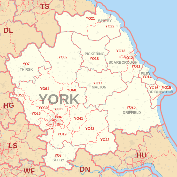
Coverage Area of Postcode YO1 to YO14
|
|
| Postcode |
Coverage Area |
Local Authority Area |
| YO1 |
City Centre |
York |
| YO7 |
Dalton, Hambleton, Thirsk, Topcliffe |
North Yorkshire |
| YO8 |
Barlby, Brayton, Bubwith, Cawood, Camblesforth, Drax, Thorpe Willoughby |
|
| YO10 |
Fishergate, Fulford, Heslington, Osbaldwick, Tang Hall |
York |
| YO11 |
Cayton |
North Yorkshire |
| YO12 |
Seamer |
North Yorkshire |
| YO13 |
Scarborough |
North Yorkshire |
| YO14 |
Filey |
North Yorkshire |
Total Sales By Postcode
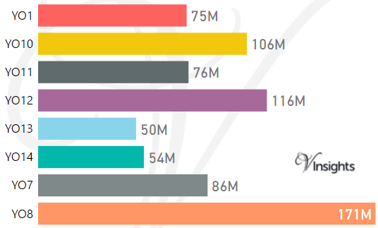
*M represents Million Pounds
Average & Median Sales Price By Postcode
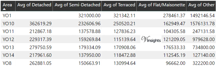
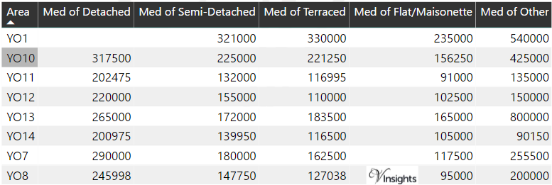
*Average and Median Sales Price are in Pounds
Spread of Sales Price By Postcode
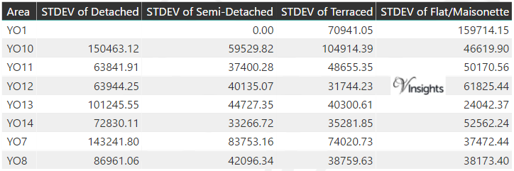
*STDEV is Standard Deviation
For example,
- Say the average detached property price for postcode XYZ is £300 K and ST. DEV. is 30 K.
- It means that most detached properties in postcode XYZ (about 68%) has price within one ST. Dev. i.e. the price range is £270K - £330K.
- All-most all detached property price (95%) in postcode XYZ lie between two ST. Dev. i.e. £240 K - £360 K
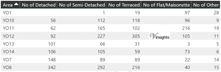
Total Number Of Sales By Postcode
Property Posts for Postcode Area YO
Schools for Postcode Area YO
- YO Postcode Area - YO1, YO7, YO8, Y10, YO11, YO12, YO13, YO14 School Details
- YO Postcode Area - YO15, YO16, YO17, YO18, YO19, YO21, YO22 School Details
- YO Postcode Area - YO23, YO24, YO25, YO26, YO30, YO31, YO32 School Details
- YO Postcode Area - YO41, YO42, YO43, YO51, YO60, YO61, YO62, YO90 School Details
All Yorkshire & Humber Postcode Area Posts
Reference
YO Postcode Area As Per Wikipedia
4b447669-d0ca-40c7-ba17-9ff58ad4cf4f|0|.0|27604f05-86ad-47ef-9e05-950bb762570c
Please click here for the updated version of this post
This Post covers
- Coverage Area of Postcode WF10 to WF17
- Total Sales By Postcode WF10 to WF17
- Average & Median Sales Price By Postcode WF10 to WF17
- Spread of Sales Price By Postcode WF10 to WF17
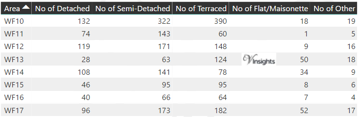
- Total Number of Sales By Postcode WF10 to WF17
- Other Property Posts for Postcode Area WF
- Schools for Postcode Area WF
Coverage Area of Postcode WF10 to WF17
|
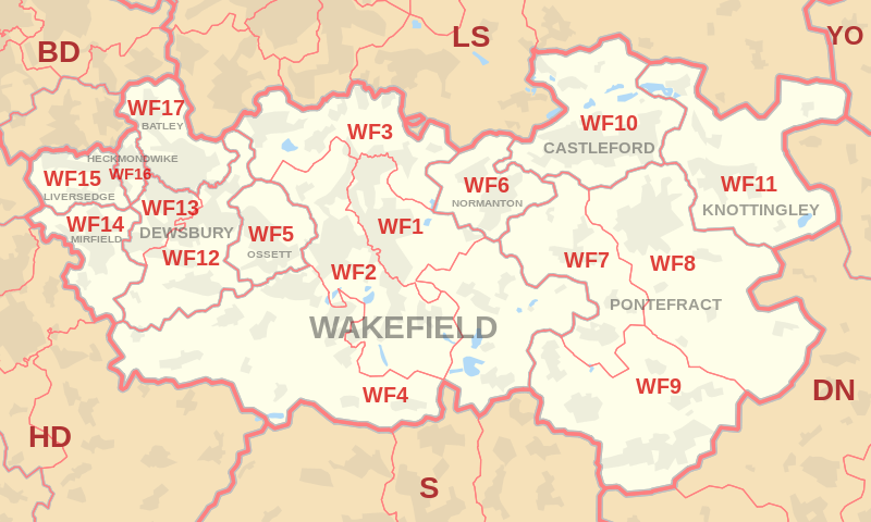
|
| Postcode |
Coverage Area |
Local Authority Area |
| WF10 |
Airedale, Allerton Bywater, Castleford, Glasshoughton |
Wakefield, Leeds |
| WF11 |
Brotherton, Byram, Cridling Stubbs, Fairburn, Kellingley, Knottingley |
Wakefield, Selby |
| WF12 |
Chickenley, Dewsbury, Savile Town, Shaw Cross, Thornhill, Thornhill Lees |
Kirklees, Wakefield |
| WF13 |
Dewsbury Moor, Ravensthorpe |
Kirklees |
| WF14 |
Hopton, Mirfield |
Kirklees |
| WF15 |
Roberttown, Liversedge |
Kirklees |
| WF16 |
Heckmondwike |
Kirklees |
| WF17 |
Birstall, Batley, Staincliffe |
Kirklees |
Total Sales By Postcode
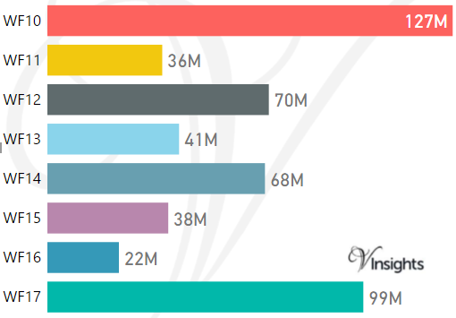
*M represents Million Pounds
Average & Median Sales Price By Postcode
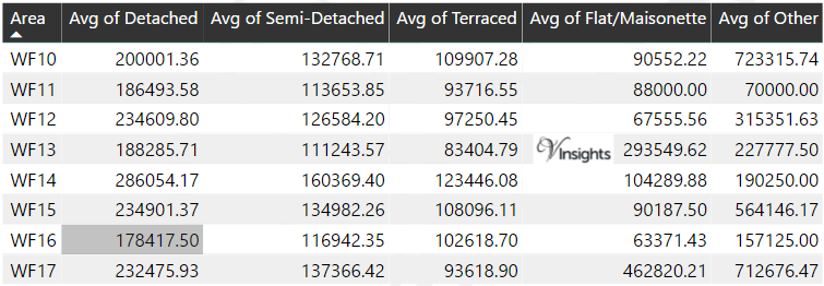
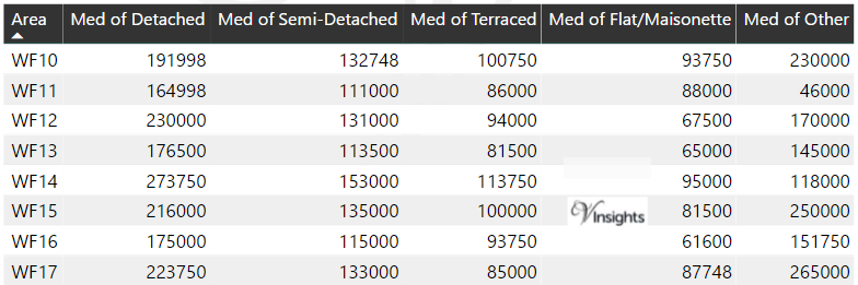
*Average and Median Sales Price are in Pounds
Spread of Sales Price By Postcode
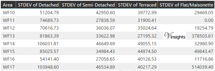
*STDEV is Standard Deviation
For example,
- Say the average detached property price for postcode XYZ is £300 K and ST. DEV. is 30 K.
- It means that most detached properties in postcode XYZ (about 68%) has price within one ST. Dev. i.e. the price range is £270K - £330K.
- All-most all detached property price (95%) in postcode XYZ lie between two ST. Dev. i.e. £240 K - £360 K
Total Number Of Sales By Postcode
Property Posts for Postcode Area WF
Schools for Postcode Area WF
- WF Postcode Area - WF1, WF2, WF3, WF4, WF5, WF6, WF7, WF8, WF9 School Details
- WF Postcode Area - WF10, WF11, WF12, WF13, WF14, WF15, WF16, WF17 School Details
All Yorkshire & Humber Postcode Area Posts
Reference
WF Postcode Area As Per Wikipedia
ed80464e-80e1-458f-8fb9-9e2ad9abb14c|0|.0|27604f05-86ad-47ef-9e05-950bb762570c
Please click here for the updated version of this post
This Post covers
- Coverage Area of Postcode WF1 to WF9
- Total Sales By Postcode WF1 to WF9
- Average & Median Sales Price By Postcode WF1 to WF9
- Spread of Sales Price By Postcode WF1 to WF9
- Total Number of Sales By Postcode WF1 to WF9
- Property Posts for Postcode Area WF
- Schools for Postcode Area WF
Coverage Area of Postcode WF1 to WF9
|
|
| Postcode |
Coverage Area |
Local Authority Area |
| WF1 |
Eastmoor, Kirkthorpe, Newton Hill, Outwood, Wakefield City Centre |
Wakefield |
| WF2 |
Alverthorpe, Carr Gate, Flanshaw, Hall Green, Kirkhamgate, Kettlethorpe, Lupset, Portobello, Newmillerdam, Sandal, Thornes, Walton (Wakefield), Wrenthorpe, Woolgreaves, Peacock, Pledwick |
Wakefield |
| WF3 |
Carlton, East Ardsley, Lofthouse, Lofthouse Gate, Robin Hood, Stanley, Thorpe, Tingley, West Ardsley |
Leeds, Wakefield |
| WF4 |
Crigglestone, Crofton, Durkar, Flockton, Havercroft, Horbury, Netherton, New Crofton, Ryhill, West Bretton, Woolley |
Wakefield, Kirklees |
| WF5 |
Gawthorpe, Healey, Ossett (very small area around Wakefield Road falls in the Kirkless district) |
Wakefield, Kirklees |
| WF6 |
Altofts, Normanton |
Wakefield |
| WF7 |
Ackworth Moor Top, Featherstone, Purston Jaglin, Streethouse |
Wakefield |
| WF8 |
Darrington, Kirk Smeaton, Pontefract (Monkhill), Thorpe Audlin |
Wakefield, Selby, Doncaster |
| WF9 |
Badsworth, Fitzwilliam, Hemsworth, Kinsley, South Elmsall, South Kirkby, Upton |
Wakefield, Doncaster |
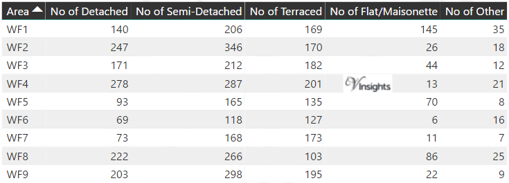
Total Sales By Postcode
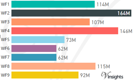
*M represents Million Pounds
Average & Median Sales Price By Postcode
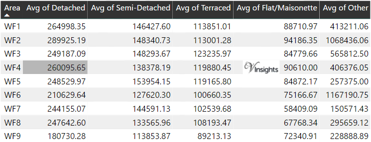
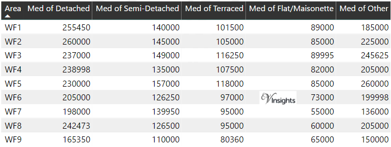
*Average and Median Sales Price are in Pounds
Spread of Sales Price By Postcode
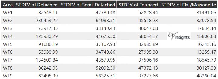
*STDEV is Standard Deviation
For example,
- Say the average detached property price for postcode XYZ is £300 K and ST. DEV. is 30 K.
- It means that most detached properties in postcode XYZ (about 68%) has price within one ST. Dev. i.e. the price range is £270K - £330K.
- All-most all detached property price (95%) in postcode XYZ lie between two ST. Dev. i.e. £240 K - £360 K
Total Number Of Sales By Postcode
Property Posts for Postcode Area WF
Schools for Postcode Area WF
- WF Postcode Area - WF1, WF2, WF3, WF4, WF5, WF6, WF7, WF8, WF9 School Details
- WF Postcode Area - WF10, WF11, WF12, WF13, WF14, WF15, WF16, WF17 School Details
All Yorkshire & Humber Postcode Area Posts
Reference
WF Postcode Area As Per Wikipedia
73716a57-3486-45c1-ad62-95dfe95820b9|0|.0|27604f05-86ad-47ef-9e05-950bb762570c
Please click here for the updated version of this post
This Post covers
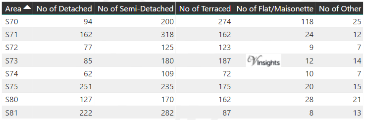
- Coverage Area of Postcode S70 to S81
- Total Sales By Postcode S70 to S81
- Average & Median Sales Price By Postcode S70 to S81
- Spread of Sales Price By Postcode S70 to S81
- Total Number of Sales By Postcode S70 to S81
- Other Property Posts for Postcode Area S
- Schools for Postcode Area S
Coverage Area of Postcode S70 to S81
|
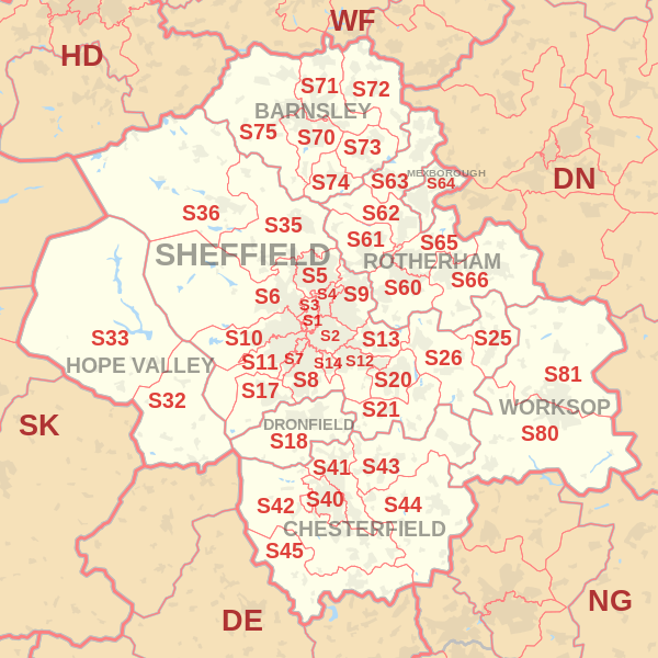
|
| Postcode |
Coverage Area |
Local Authority Area |
| S70 |
Central Barnsley, Birdwell, Stairfoot, Worsborough, Kendray |
Barnsley |
| S71 |
Ardsley, Athersley, Monk Bretton, Lundwood, Royston |
Barnsley |
| S72 |
Brierley, Cudworth, Grimethorpe, Shafton, South Hiendley |
Barnsley, Wakefield |
| S73 |
Brampton, Darfield, Wombwell, Hemingfield |
Barnsley, Rotherham |
| S74 |
Elsecar, Hoyland, Jump, Blacker Hill |
Barnsley |
| S75 |
Barugh Green, Cawthorne, Darton, Dodworth, Gawber, Mapplewell, Pogmoor, Staincross, Wilthorpe, Tankersley, Kexborough |
Barnsley |
| S80 |
Creswell, Thorpe Salvin, South Worksop, Whitwell |
Bassetlaw, Bolsover, Rotherham |
| S81 |
Blyth, Carlton-in-Lindrick, Langold, North Worksop, Shireoaks, Woodsetts |
Bassetlaw, Rotherham |
Total Sales By Postcode
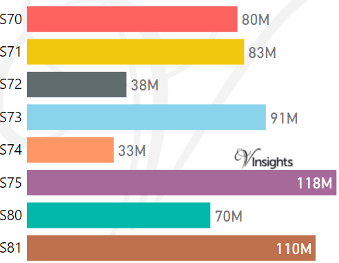
*M represents Million Pounds
Average & Median Sales Price By Postcode
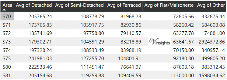
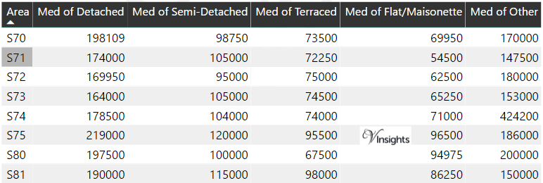
*Average and Median Sales Price are in Pounds
Spread of Sales Price By Postcode
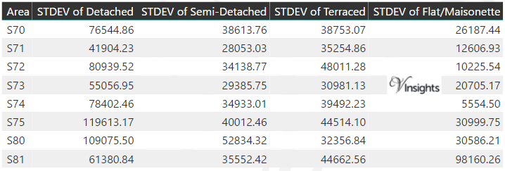
*STDEV is Standard Deviation
For example,
- Say the average detached property price for postcode XYZ is £300 K and ST. DEV. is 30 K.
- It means that most detached properties in postcode XYZ (about 68%) has price within one ST. Dev. i.e. the price range is £270K - £330K.
- All-most all detached property price (95%) in postcode XYZ lie between two ST. Dev. i.e. £240 K - £360 K
Total Number Of Sales By Postcode
Property Posts for Postcode Area S
Schools for Postcode Area S
- Sheffield S Postcode Area - S1, S2, S3, S4, S5, S6, S7, S8, S9 School Details
- S Postcode Area - S10, S11, S12, S13, S14, S17, S18 School Details
- S Postcode Area - S20, S21, S25, S26, S32, S33, S35, S36 School Details
- S Postcode Area - S40, S41, S42, S43, S44, S45 School Details
- S Postcode Area - S60, S61, S62, S63, S64, S65, S66 School Details
- S Postcode Area - S70, S71, S72, S73, S74, S75, S80, S81 School Details
All Yorkshire & Humber Postcode Area Posts
Reference
S Postcode Area As Per Wikipedia
729ae16d-669a-41a3-b7cd-82c4096c824c|0|.0|27604f05-86ad-47ef-9e05-950bb762570c