Please click here for the updated version of this post
This Post covers
- Coverage Area of Postcode EC1A to EC1Y
- Total Sales By Postcode EC1A to EC1Y
- Average & Median Sales Price By Postcode EC1A to EC1Y
- Total Number of Sales By Postcode EC1A to EC1Y
- Multi Year Property Trend Analysis For Postcode EC1A to EC1Y
- Schools for Postcode Area EC
- Posts for Postcode Area EC
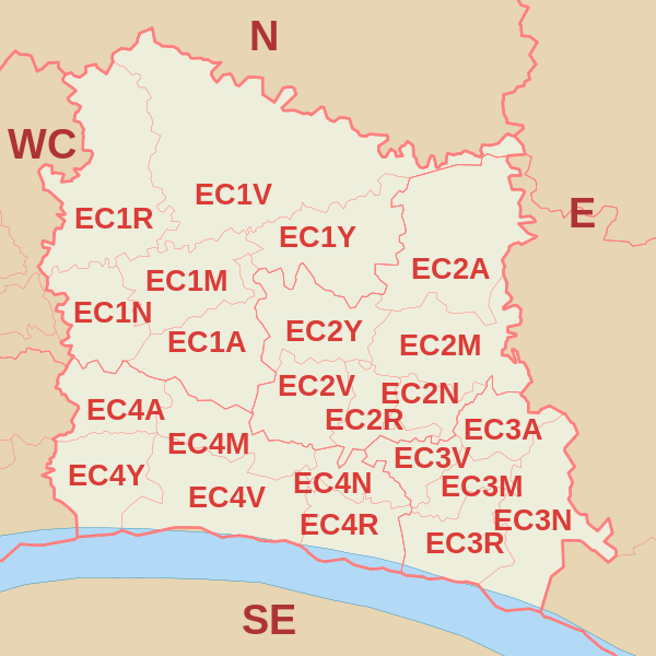
Coverage Area of Postcode EC1A to EC1Y
 |
| Postcode |
Coverage Area |
Local Authority Area |
| EC1A |
St Bartholomew's Hospital |
City Of London, Islington |
| EC1M |
Clerkenwell, Farringdon |
Islington, Camden, City of London |
| EC1N |
Hatton Garden |
Camden, City of London |
| EC1R |
Finsbury, Finsbury Estate (west) |
Islington, Camden |
| EC1V |
Finsbury (east), Moorfields Eye Hospital |
Islington, Hackney, Brent |
| EC1Y |
St Luke's, Bunhill Fields |
Islington, City of London |
Total Sales By Postcode in 2016
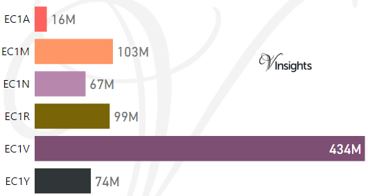
*M represents millions
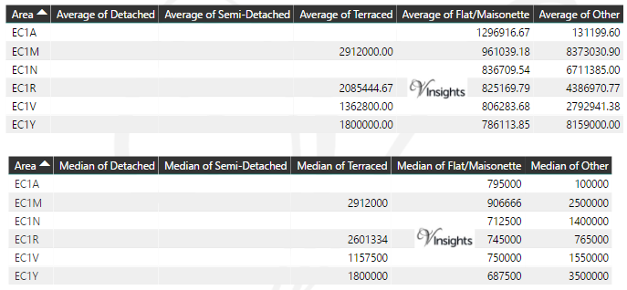
Average & Median Sales Price By Postcode in 2016
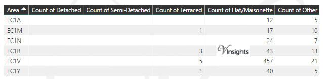
Total Number Of Sales By Postcode in 2016
Multi Year Property Trend Analysis By Postcode
Schools for Postcode Area EC
- London EC Postcode Area - EC1A, EC1M, EC1N, EC1R, EC1V, EC1Y School Details
- London EC Postcode Area - EC2A, EC2M, EC2N, EC2R, EC2V, EC2Y School Details
- London EC Postcode Area - EC3A, EC3M, EC3N, EC3R, EC3V School Details
- London EC Postcode Area - EC4A, EC4M, EC4N, EC4R, EC4V, EC4Y School Details
Posts for Postcode Area EC
- London EC Postcode Area - EC2A, EC2M, EC2N, EC2P, EC2R, EC2V, EC2Y Property Market 2016
- London EC Postcode Area - EC3A, EC3M, EC3N, EC3R, EC3V Property Market 2016
- London EC Postcode Area - EC4A, EC4M, EC4N, EC4R, EC4V, EC4Y Property Market 2016
- All EC Postcodes Yearly & Trend Analysis Posts
All EC Postcode Area Posts

Reference
EC Postcode Area As Per Wikipedia
a18733dc-5945-4f7f-8b68-27e94a8b9a11|0|.0|27604f05-86ad-47ef-9e05-950bb762570c
Please click here for the updated version of this post
This Post covers
- Coverage Area of Postcode E10 to E20
- Total Sales By Postcode E10 to E20
- Average & Median Sales Price By Postcode E10 to E20
- Total Number of Sales By Postcode E10 to E20
- Multi Year Property Trend Analysis For Postcode E10 to E20
- Schools for Postcode Area E
- Posts for Postcode Area E
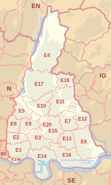
Coverage Area of Postcode E10 to E20
 |
| Postcode |
Coverage Area |
Local Authority Area |
| E10 |
Leyton district: Leyton, Temple Mills, Hackney Marshes (part) Upper Clapton (part), Walthamstow Marshes |
Waltham Forest, Hackney |
| E11 |
Leytonstone district: Leytonstone, Wanstead, Aldersbrook (part), Snaresbrook, Cann Hall |
Waltham Forest, Redbridge |
| E12 |
Manor Park district: Manor Park, Little Ilford, Aldersbrook (part) |
Newham, Redbridge,Barking and Dagenham |
| E13 |
Plaistow district: Plaistow, West Ham (part), Upton Park (part) |
Newham |
| E14 |
Poplar district: Poplar, Isle of Dogs, Limehouse, Canary Wharf, Millwall, Blackwall, Cubitt Town, South Bromley, North Greenwich, Leamouth |
Tower Hamlets |
| E15 |
Stratford district: Stratford, West Ham (part), Maryland, Leyton (part), Leytonstone (part) Temple Mills (part), Hackney Wick (part), Bow (part) |
Newham, Waltham Forest, Hackney, Tower Hamlets |
| E16 |
Victoria Docks and North Woolwich district: Canning Town, Silvertown, Royal Docks, North Woolwich, Beckton (part) |
Newham |
| E17 |
Walthamstow district: Walthamstow, Upper Walthamstow, Leyton (part) |
Waltham Forest |
| E18 |
Woodford and South Woodford district: Woodford, South Woodford |
Redbridge |
| E20 |
Olympic Park district: Olympic Park, & parts of Stratford, Homerton, Leyton, Bow |
Newham, Waltham Forest, Hackney, Tower Hamlets |
Total Sales By Postcode in 2016
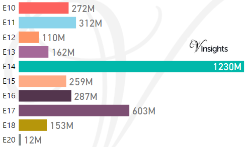
*M represents millions
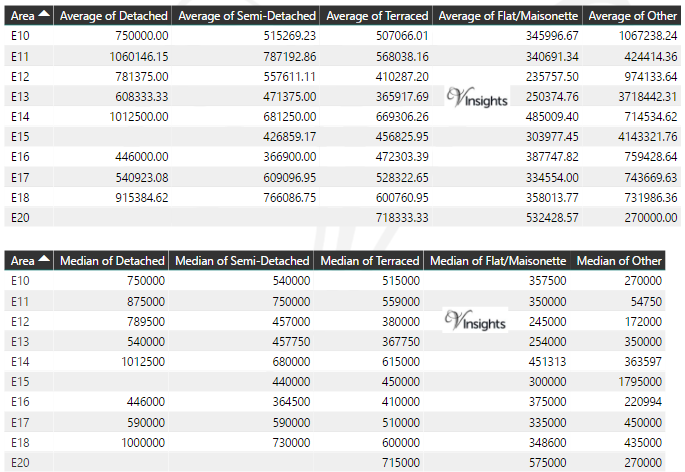
Average & Median Sales Price By Postcode in 2016
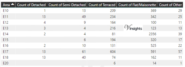
Total Number Of Sales By Postcode in 2016
Multi Year Property Trend Analysis By Postcode
Schools for Postcode Area E
- London E Postcode Area - E1, E1W, E2, E3, E4, E5, E6, E7, E8, E9 School Details
- London E Postcode Area - E10, E11, E12, E13, E14, E15, E16, E17, E18, E20 School Details
Posts for Postcode Area E
All E Postcode Area Posts
Reference
E Postcode Area As Per Wikipedia
eb8418d2-faea-4aeb-b60a-7642123078df|0|.0|27604f05-86ad-47ef-9e05-950bb762570c
Please click here for the updated version of this post
This Post covers
- Coverage Area of Postcode E1 to E9
- Total Sales By Postcode E1 to E9
- Average & Median Sales Price By Postcode E1 to E9
- Total Number of Sales By Postcode E1 to E9
- Multi Year Property Trend Analysis For Postcode E1 to E9
- Schools for Postcode Area E
- Posts for Postcode Area E
Coverage Area of Postcode E1 to E9
|
| Postcode |
Coverage Area |
Local Authority Area |
| E1 |
Eastern head district: Aldgate (part), Bishopsgate (part), Whitechapel, Shoreditch (part), Spitalfields, Shadwell, Stepney, Globe Town (part), Mile End (part), Portsoken, Brick Lane |
Tower Hamlets, Hackney, City of London |
| E1W |
Wapping |
Tower Hamlets |
| E2 |
Bethnal Green district: Bethnal Green, Haggerston, Hoxton, Shoreditch (part), Cambridge Heath, Globe Town (part) |
Tower Hamlets, Hackney |
| E3 |
Bow district: Bow, Bromley-by-Bow, Old Ford, Mile End, Fish Island, Bow Common, Poplar (part) Limehouse (part) Three Mills, London Gas Museum |
Tower Hamlets, Newham |
| E4 |
Chingford district: Chingford, Sewardstone, Highams Park, Upper Edmonton (part), Woodford Green (part) |
Waltham Forest, Enfield, Epping Forest |
| E5 |
Clapton district: Leyton (Part), Upper Clapton, Lower Clapton, Stoke Newington (part) |
Hackney,Waltham Forest |
| E6 |
East Ham district: East Ham, Beckton, Upton Park (part), Barking (part) |
Newham, Barking and Dagenham |
| E7 |
Forest Gate district: Forest Gate, Leytonstone (Part), Stratford (part) |
Newham, Waltham Forest |
| E8 |
Hackney district: Hackney Central, Dalston, London Fields, Stoke Newington (part) |
Hackney |
| E9 |
Homerton district: Homerton, Hackney Wick, South Hackney, Hackney Marshes, Victoria Park |
Hackney, Tower Hamlets |
Total Sales By Postcode in 2016
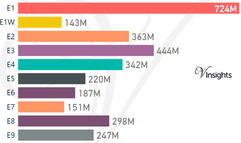
*M represents millions
Average & Median Sales Price By Postcode in 2016
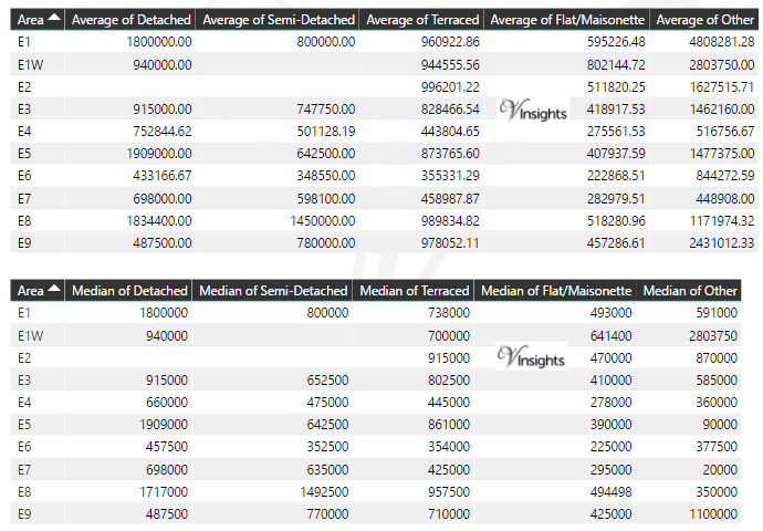
Total Number Of Sales By Postcode in 2016
Multi Year Property Trend Analysis By Postcode
Schools for Postcode Area E
- London E Postcode Area - E1, E1W, E2, E3, E4, E5, E6, E7, E8, E9 School Details
- London E Postcode Area - E10, E11, E12, E13, E14, E15, E16, E17, E18, E20 School Details
Posts for Postcode Area E
All E Postcodes Yearly & Trend Analysis Posts
Reference
E Postcode Area As Per Wikipedia
3cc1e1e9-840e-4e93-a7c9-53449ad8be57|0|.0|27604f05-86ad-47ef-9e05-950bb762570c
Please click here for the updated version of this post
This Post covers
- Coverage Area of Postcode DA10 to DA18
- Total Sales By Postcode DA10 to DA18
- Average & Median Sales Price By Postcode DA10 to DA18
- Total Number of Sales By Postcode DA10 to DA18
- Multi Year Property Trend Analysis For Postcode DA10 to DA18
- Schools for Postcode Area DA
- Posts for Postcode Area DA
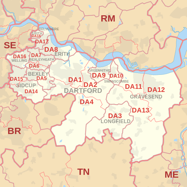
Coverage Area of Postcode DA10 to DA18
 |
| Postcode |
Coverage Area |
Local Authority Area |
| DA10 |
Swanscombe, Ebbsfleet |
Dartford |
| DA11 |
Gravesend (west), Northfleet |
Dartford, Gravesham |
| DA12 |
Gravesend (east), Chalk, Shorne, Cobham |
Gravesham |
| DA13 |
Meopham, Istead Rise, Vigo, Southfleet |
Dartford, Gravesham, Sevenoaks, Tonbridge and Malling |
| DA14 |
Sidcup, Foots Cray, North Cray, Longlands, Ruxley, part of Albany Park |
Bexley, Bromley |
| DA15 |
Sidcup (north), Blackfen, Lamorbey, Longlands |
Bexley, Greenwich |
| DA16 |
Welling, Falconwood, East Wickham |
Bexley, Greenwich |
| DA17 |
Belvedere, Lessness Heath |
Bexley |
| DA18 |
Erith Marshes, Thamesmead (part) |
Bexley |
Total Sales By Postcode in 2016
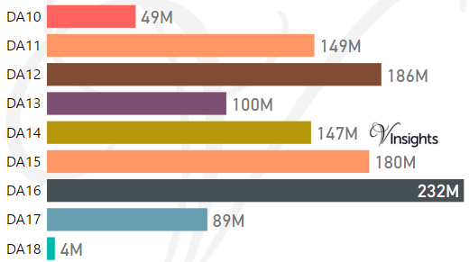
*M represents millions
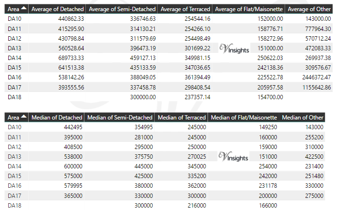
Average & Median Sales Price By Postcode in 2016
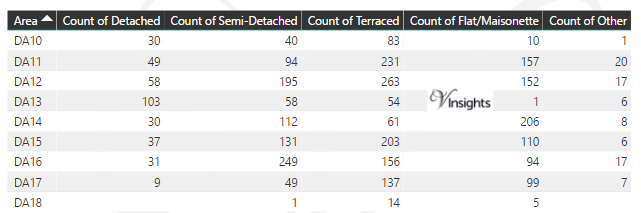
Total Number Of Sales By Postcode
Multi Year Trend Analysis By Postcode in 2016
Schools for Postcode Area DA
- DA Postcode Area - DA1, DA2, DA3, DA4, DA5, DA6, DA7, DA8, DA9 School Details
- DA Postcode Area - DA10, DA11, DA12, DA13, DA14, DA15, DA16, DA17, DA18 School Details
Posts for Postcode Area DA
All DA Postcode Area Posts
Reference
DA Postcode Area As Per Wikipedia
08dbbb1a-a41e-4714-8b54-5e846b4f68ad|0|.0|27604f05-86ad-47ef-9e05-950bb762570c
Please click here for the updated version of this post
This Post covers
- Coverage Area of Postcode DA1 to DA9
- Total Sales By Postcode DA1 to DA9
- Average & Median Sales Price By Postcode DA1 to DA9
- Total Number of Sales By Postcode DA1 to DA9
- Multi Year Property Trend Analysis For Postcode DA1 to DA9
- Schools for Postcode Area DA
- Posts for Postcode Area DA
Coverage Area of Postcode DA1 to DA9
|
| Postcode |
Coverage Area |
Local Authority Area |
| DA1 |
Dartford, Crayford, Barnes Cray |
Bexley, Dartford |
| DA2 |
Dartford (east), Stone, Wilmington, Bean, Hawley, Darenth, part of Joyden's Wood |
Dartford, Sevenoaks |
| DA3 |
Longfield, Hartley, New Ash Green, New Barn, Fawkham |
Dartford, Gravesham, Sevenoaks |
| DA4 |
Farningham, Eynsford, South Darenth, Sutton-at-Hone, Horton Kirby |
Dartford, Sevenoaks |
| DA5 |
Bexley, parts of Albany Park and Joyden's Wood |
Bexley, Dartford |
| DA6 |
Bexleyheath, Upton |
Bexley |
| DA7 |
Bexleyheath (north), Barnehurst |
Bexley |
| DA8 |
Erith, Northumberland Heath, Slade Green |
Bexley |
| DA9 |
Greenhithe, Stone |
Dartford |
Total Sales By Postcode in 2016
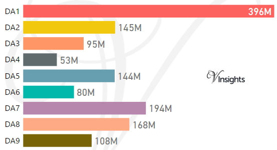
*M represents millions
Average & Median Sales Price By Postcode in 2016
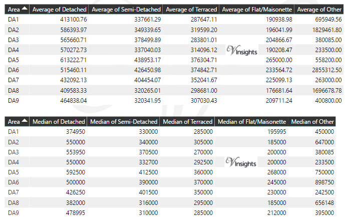
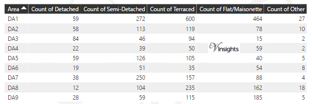
Total Number Of Sales By Postcode in 2016
Multi Year Trend Analysis By Postcode
Schools for Postcode Area DA
- DA Postcode Area - DA1, DA2, DA3, DA4, DA5, DA6, DA7, DA8, DA9 School Details
- DA Postcode Area - DA10, DA11, DA12, DA13, DA14, DA15, DA16, DA17, DA18 School Details
Posts for Postcode Area DA
All DA Postcode Area Posts
Reference
DA Postcode Area As Per Wikipedia
f0de4575-c599-40e3-a0e4-9c32c325851b|0|.0|27604f05-86ad-47ef-9e05-950bb762570c