Please click here for the updated version of this post
This Post covers
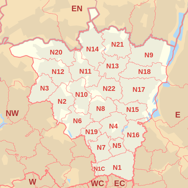
- Coverage Area of Postcode N10 to N19
- Total Sales By Postcode N10 to N19
- Average & Median Sales Price By Postcode N10 to N19
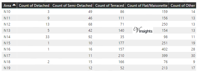
- Total Number of Sales By Postcode N10 to N19
- Multi Year Property Trend Analysis For Postcode N10 to N19
- Schools for Postcode Area N
- Posts for Postcode Area N
Coverage Area of Postcode N10 to N19
 |
| Postcode |
Coverage Area |
Local Authority Area |
| N10 |
Muswell Hill |
Haringey, Barnet |
| N11 |
New Southgate, Friern Barnet, Bounds Green, Arnos Grove (part) |
Enfield, Barnet, Haringey |
| N12 |
North Finchley, Woodside Park |
Barnet |
| N13 |
Palmers Green |
Enfield, Haringey |
| N14 |
Southgate, Oakwood, Arnos Grove (part) |
Enfield, Barnet |
| N15 |
South Tottenham, Harringay (part), West Green, Seven Sisters, Stamford Hill (part) |
Hackney, Haringey |
| N16 |
Stoke Newington, Stamford Hill (part), Shacklewell, Dalston (part), Newington Green (part) |
Islington, Hackney, Harrow |
| N17 |
Tottenham, Wood Green (part) |
Haringey |
| N18 |
Upper Edmonton, Edmonton (part) |
Enfield,Haringey |
| N19 |
Upper Holloway, Archway, Tufnell Park (part) |
Islington, Camden |
Total Sales By Postcode in 2016
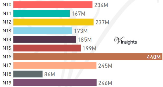
*M represents millions
Average & Median Sales Price By Postcode in 2016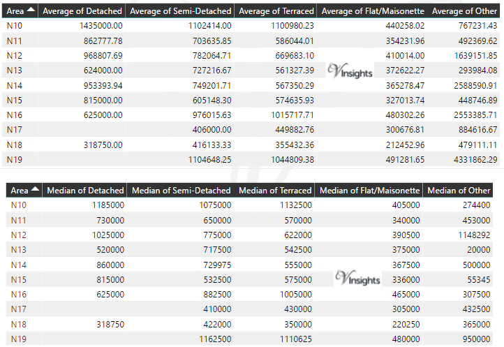
Total Number Of Sales By Postcode in 2016
Multi Year Property Trend Analysis By Postcode
Schools for Postcode Area N
- London N Postcode Area - N1, N1C, N2, N3, N4, N5, N6, N7, N8, N9 School Details
- London N Postcode Area - N10, N11, N12, N13, N14, N15, N16, N17, N18, N19 School Details
- London N Postcode Area - N20, N21, N22 School Details
Posts for Postcode Area N
All N Postcode Area Posts

Reference
N Postcode Area As Per Wikipedia
ba4e458b-b549-4d6d-b25f-ad0049adc8d2|0|.0|27604f05-86ad-47ef-9e05-950bb762570c