Please click here for the updated version of this post
This Post covers
- Coverage Area of Postcode KT10 to KT19
- Total Sales By Postcode KT10 to KT19
- Average & Median Sales Price By Postcode KT10 to KT19
- Total Number of Sales By Postcode KT10 to KT19
- Multi Year Property Trend Analysis For Postcode KT10 to KT19
- Schools for Postcode Area KT
- Posts for Postcode Area KT
Coverage Area of Postcode KT10 to KT19
 |
| Postcode |
Coverage Area |
Local Authority Area |
| KT10 |
Esher, Claygate, Hinchley Wood |
Elmbridge |
| KT11 |
Cobham, Stoke d'Abernon, Downside, Hatchford, parts of Wisley, Ockham and Hersham |
Elmbridge, Guildford, Mole Valley |
| KT12 |
Walton-on-Thames, Hersham, Whiteley Village |
Elmbridge |
| KT13 |
Weybridge, Oatlands, Saint George's Hill, Hamm Court |
Elmbridge, Runnymede |
| KT14 |
Byfleet, West Byfleet |
Woking, Elmbridge, Runnymede |
| KT15 |
Addlestone, New Haw, Woodham |
Runnymede, Woking |
| KT16 |
Chertsey, Ottershaw, Longcross, Lyne, Dumsey Meadow in Littleton |
Runnymede, Spelthorne |
| KT17 |
Epsom, Ewell, Stoneleigh |
Epsom and Ewell, Reigate and Banstead, Sutton |
| KT18 |
Epsom, Tattenham Corner, Headley, Langley Vale |
Epsom and Ewell, Mole Valley, Reigate and Banstead |
| KT19 |
Epsom, West Ewell, Stoneleigh, Horton, Longmead |
Epsom and Ewell |
Total Sales By Postcode in 2016
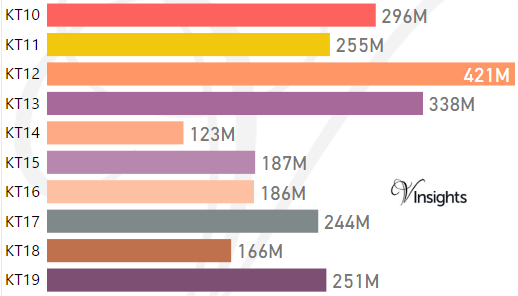
*M represents millions
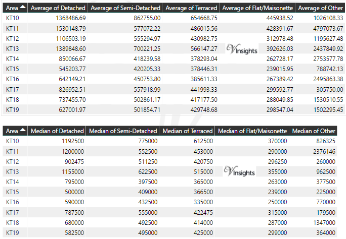
Average & Median Sales Price By Postcode in 2016
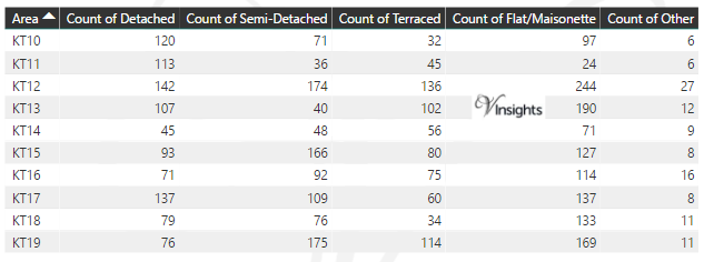
Total Number Of Sales By Postcode in 2016
Multi Year Property Trend Analysis By Postcode
Schools for Postcode Area KT
- KT Postcode Area - KT1, KT2, KT3, KT4, KT5, KT6, KT7, KT8, KT9 School Details
- KT Postcode Area - KT10, KT11, KT12, KT13, KT14, KT15, KT16, KT17, KT18, KT19 School Details
- KT Postcode Area - KT20, KT21, KT22, KT23, KT24 School Details
Posts for Postcode Area KT
All KT Postcode Area Posts

Reference
KT Postcode Area As Per Wikipedia
b9486d21-8b93-46ea-a558-b008d6a47822|0|.0|27604f05-86ad-47ef-9e05-950bb762570c