
This Post covers
- Coverage Area of Postcode DH1 to DH9
- School Details for Postcode Area DH1 to DH9
- Property Market Posts for Postcode Area DH
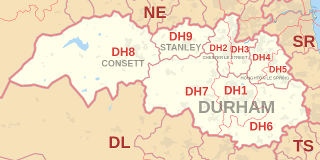
Coverage Area of Postcode DH1 to DH9
|
| Postcode |
Coverage Area |
Local Authority Area |
| DH1 |
Durham |
County Durham |
| DH2 |
Chester-Le-Street (west of East Coast Main Line), Ouston, Pelton, Birtley (west of East Coast Main Line) |
County Durham, Gateshead |
| DH3 |
Chester-le-Street (east of East Coast Main Line), Great Lumley, Birtley (east of East Coast Main Line) |
County Durham, Gateshead |
| DH4 |
Houghton le Spring (West of A690), Penshaw, Shiney Row |
County Durham, Sunderland |
| DH5 |
Houghton le Spring (East of A690), Hetton-le-Hole |
Sunderland |
| DH6 |
South Hetton, Haswell, Shotton Colliery, Ludworth, Shadforth, Sherburn, Littletown, Kelloe, Coxhoe , Bowburn, Cassop, Pittington, Thornley, Wheatly Hill |
County Durham |
| DH7 |
Brandon, Lanchester, Esh Winning, Burnhope, Langley Park, Sacriston, Ushaw Moor, Brancepeth |
County Durham |
| DH8 |
Consett, Blackhill, Bridgehill, Shotley Bridge, Leadgate, Delves Lane |
County Durham, Northumberland County Council |
| DH9 |
Dipton, Stanley, Annfield Plain |
County Durham |
where *F.S. = Faith School, *PERF = Performance, *D.F.E.=Department For Education
Schools in Postcode DH1
Schools in Postcode DH2
Schools in Postcode DH3
Schools in Postcode DH4
Schools in Postcode DH5
Schools in Postcode DH6
Schools in Postcode DH7
Schools in Postcode DH8
Schools in Postcode DH9
where *F.S. = Faith School, *PERF = Performance, *D.F.E.=Department For Education
Property Market Posts for Postcode Area DH
All North East England Schools

2165c33f-d72b-40ce-9904-7e870153fb58|0|.0|27604f05-86ad-47ef-9e05-950bb762570c