Please click here for the updated version of this post
This Post covers
- Coverage Area of Postcode N20 to N22
- Total Sales By Postcode N20 to N22
- Average & Median Sales Price By Postcode N20 to N22
- Total Number of Sales By Postcode N20 to N22
- Multi Year Property Trend Analysis For Postcode N20 to N22
- Schools for Postcode Area N
- Posts for Postcode Area N
Coverage Area of Postcode N20 to N22
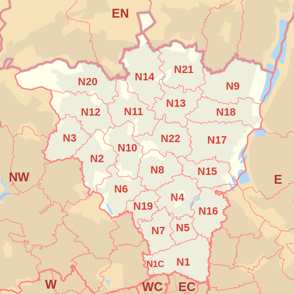 |
| Postcode |
Coverage Area |
Local Authority Area |
| N20 |
Whetstone, Totteridge, Oakleigh Park |
Barnet |
| N21 |
Winchmore Hill, Bush Hill, Grange Park |
Enfield |
| N22 |
Wood Green, Bounds Green (part), Bowes Park |
Haringey, Enfield |
Total Sales By Postcode in 2016
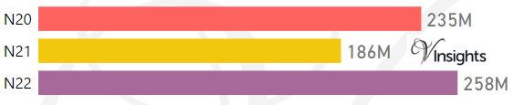
*M represents millions
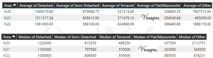
Average & Median Sales Price By Postcode in 2016
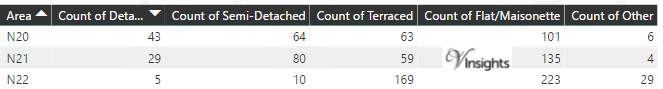
Total Number Of Sales By Postcode in 2016
Multi Year Property Trend Analysis By Postcode
Schools for Postcode Area N
- London N Postcode Area - N1, N1C, N2, N3, N4, N5, N6, N7, N8, N9 School Details
- London N Postcode Area - N10, N11, N12, N13, N14, N15, N16, N17, N18, N19 School Details
- London N Postcode Area - N20, N21, N22 School Details
Posts for Postcode Area N
All N Postcode Area Posts

Reference
N Postcode Area As Per Wikipedia
4670ce5c-e51a-443b-9fdf-a0c15411e549|0|.0|27604f05-86ad-47ef-9e05-950bb762570c