10. April 2018 12:43
/
VInsights Team
/
/
Comments (0)
Please click here for the updated version of this post
This Post covers
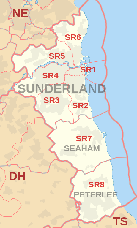
Coverage Area of Postcode SR1 to SR8
|
|
| Postcode |
Coverage Area |
Local Authority Area |
| SR1 |
Sunderland City Centre, East End, Hendon (north of Egerton Street) |
Sunderland |
| SR2 |
Ashbrooke, Ryhope, Grangetown, Hendon (south of Salisbury Street), Hillview, Thornhill |
Sunderland |
| SR3 |
Chapelgarth, Doxford Park, Farringdon, Elstob Farm, Essen Way, Gilley Law, Hall Farm, Herrington, Humbledon Hill, Mill Hill, Moorside, Plains Farm, Ryhope, Silksworth, Springwell Village, Thorney Close, Tunstall |
Sunderland |
| SR4 |
Ayres Quay, Barnes, Chester Road, Deptford, Ford Estate, Grindon, Hastings Hill, Hylton Lane Estate, High Barnes, Millfield, Tyne and Wear, Pallion, Ford Estate, Pennywell, South Hylton |
Sunderland |
| SR5 |
Carley Hill, Castletown, Downhill, Fulwell (west of Metro line), Hylton Castle, Hylton Red House, Marley Pots, Monkwearmouth (west of Metro line), Sheepfolds, Southwick, Town End Farm, Witherwack |
Sunderland |
| SR6 |
Cleadon, Fulwell (east of Metro line), Monkwearmouth (east of Metro line), North Haven, Roker, St Peter's Riverside, Seaburn, Seaburn Dene, South Bents, Whitburn |
Sunderland, South Tyneside |
| SR7 |
Cold Hesledon, Dalton-le-Dale, Dawdon, Deneside, Greenhill, Murton, Northlea, Parkside, Seaham, West Lea |
County Durham |
| SR8 |
Easington, Easington Colliery, Horden, Little Thorpe, Peterlee |
County Durham |
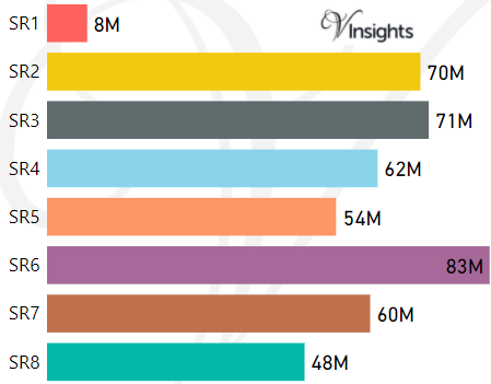
- M represents Million Pounds
- Total value includes Property Type Other apart from Detached, Semi-Detached, Terraced, Flat/Masionette
Schools for Postcode Area SR
Property Posts for Postcode Area SR
6987c8ff-04d5-4089-91c4-b765c16513cb|0|.0|27604f05-86ad-47ef-9e05-950bb762570c
Tags :
10. April 2018 09:54
/
VInsights Team
/
/
Comments (0)
Please click here for the updated version of this post
This Post covers
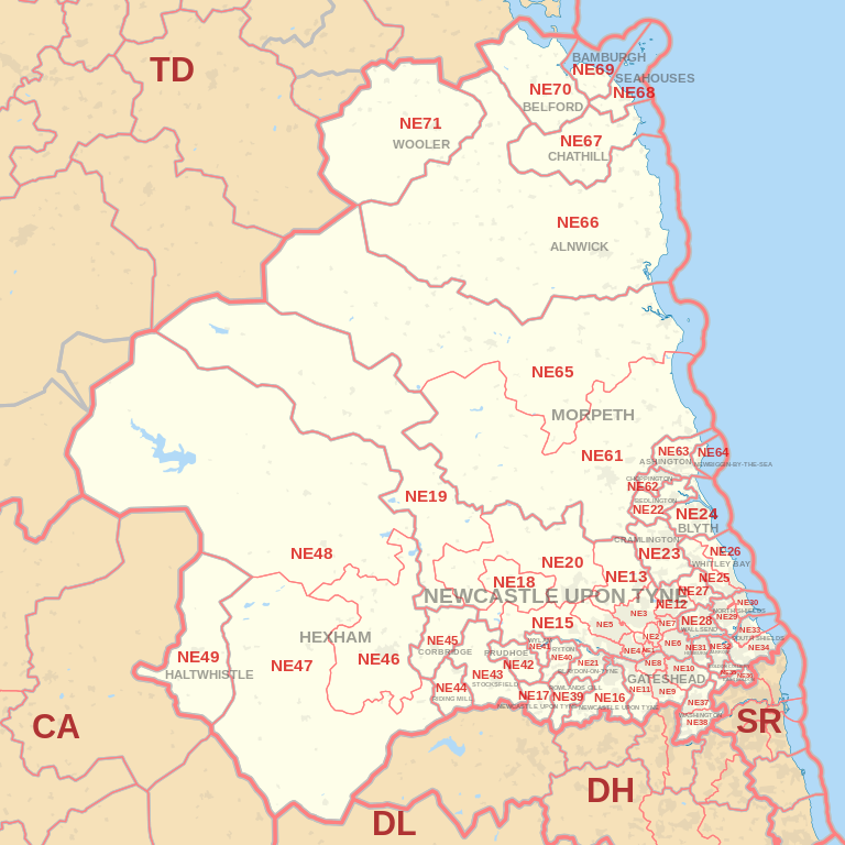
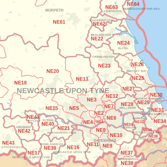
Coverage Area of Postcode NE61 to NE71
|
|
| Postcode |
Coverage Area |
Local Authority Area |
| NE61 |
Morpeth, Tranwell, Clifton, Hepscott, Mitford |
Northumberland |
| NE62 |
Scotland Gate, Guidepost, Stakeford, West Sleekburn, Bomarsund |
Northumberland |
| NE63 |
Ashington |
Northumberland |
| NE64 |
Newbiggin-by-the-Sea |
Northumberland |
| NE65 |
Amble |
Northumberland |
| NE66 |
Alnwick, Shilbottle |
Northumberland |
| NE67 |
Chathill, Beadnell |
Northumberland |
| NE68 |
Seahouses |
Northumberland |
| NE69 |
Bamburgh |
Northumberland |
| NE70 |
Belford |
Northumberland |
| NE71 |
Wooler |
Northumberland |
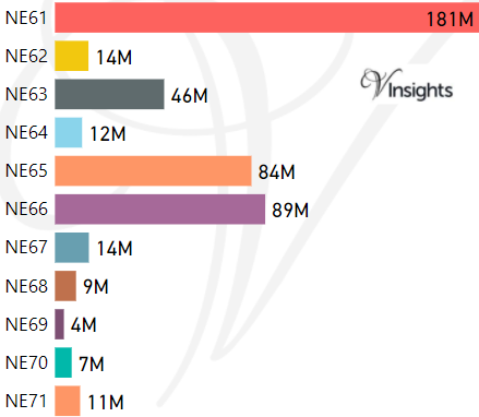
- M represents Million Pounds
- Total value includes Property Type Other apart from Detached, Semi-Detached, Terraced, Flat/Masionette
Schools for Postcode Area NE
- NE Postcode Area - NE1, NE2, NE3, NE4, NE5, NE6, NE7, NE8, NE9 School Details
- NE Postcode Area - NE10, NE11, NE12, NE13, NE15, NE16, NE17, NE18, NE19 School Details
- NE Postcode Area - NE20, NE21, NE22, NE23, NE24, NE25, NE26, NE27, NE28, NE29 School Details
- NE Postcode Area - NE30, NE31, NE32, NE33, NE34, NE35, NE36, NE37, NE38, NE39 School Details
- NE Postcode Area - NE40, NE41, NE42, NE43, NE44, NE45, NE46, NE47, NE48, NE49 School Details
- NE Postcode Area - NE61, NE62, NE63, NE64, NE65, NE66, NE67, NE68, NE69, NE70, NE71 School Details
Property Posts for Postcode Area NE
f783413f-f6b5-42dc-8615-4bd85e0c580c|0|.0|27604f05-86ad-47ef-9e05-950bb762570c
Tags :
10. April 2018 09:49
/
VInsights Team
/
/
Comments (0)
Please click here for the updated version of this post
This Post covers
Coverage Area of Postcode NE40 to NE49
|
|
| Postcode |
Coverage Area |
Local Authority Area |
| NE40 |
Ryton, Crawcrook, Greenside |
Gateshead |
| NE41 |
Wylam |
Gateshead, Northumberland |
| NE42 |
Prudhoe |
Northumberland |
| NE43 |
Stocksfield |
Northumberland |
| NE44 |
Riding Mill, Broomhaugh |
Northumberland |
| NE45 |
Corbridge |
Northumberland |
| NE46 |
Hexham |
Northumberland |
| NE47 |
Acomb, Hexhamshire |
Northumberland |
| NE48 |
Falstone, Kielder |
Northumberland |
| NE49 |
Haltwhistle |
Northumberland |
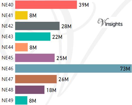
- M represents Million Pounds
- Total value includes Property Type Other apart from Detached, Semi-Detached, Terraced, Flat/Masionette
Schools for Postcode Area NE
- NE Postcode Area - NE1, NE2, NE3, NE4, NE5, NE6, NE7, NE8, NE9 School Details
- NE Postcode Area - NE10, NE11, NE12, NE13, NE15, NE16, NE17, NE18, NE19 School Details
- NE Postcode Area - NE20, NE21, NE22, NE23, NE24, NE25, NE26, NE27, NE28, NE29 School Details
- NE Postcode Area - NE30, NE31, NE32, NE33, NE34, NE35, NE36, NE37, NE38, NE39 School Details
- NE Postcode Area - NE40, NE41, NE42, NE43, NE44, NE45, NE46, NE47, NE48, NE49 School Details
- NE Postcode Area - NE61, NE62, NE63, NE64, NE65, NE66, NE67, NE68, NE69, NE70, NE71 School Details
Property Posts for Postcode Area NE
463504a5-18e6-4f53-bba8-ee240f995f3a|0|.0|27604f05-86ad-47ef-9e05-950bb762570c
Tags :
10. April 2018 09:44
/
VInsights Team
/
/
Comments (0)
Please click here for the updated version of this post
This Post covers
Coverage Area of Postcode NE30 to NE39
|
|
| Postcode |
Coverage Area |
Local Authority Area |
| NE30 |
Marden, Tynemouth, Cullercoats |
North Tyneside |
| NE31 |
Hebburn |
South Tyneside |
| NE32 |
Jarrow, Fellgate, South Tyne Tunnel |
South Tyneside |
| NE33 |
Town Centre, Deans, High Shields |
South Tyneside |
| NE34 |
Harton, Horsley Hill, Marsden, Simonside, Brockley Whins |
South Tyneside |
| NE35 |
Boldon Colliery |
South Tyneside |
| NE36 |
East Boldon, West Boldon |
South Tyneside |
| NE37 |
Usworth, Sulgrave, Albany |
Sunderland |
| NE38 |
Town Centre, Oxclose, Fatfield, Harraton |
Sunderland |
| NE39 |
Rowlands Gill, High Spen, Hamsterley Mill, Eastern Chopwell Wood |
Gateshead, County Durham |
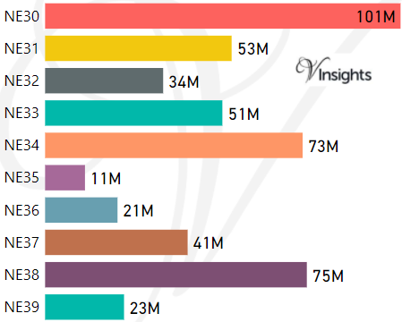
- M represents Million Pounds
- Total value includes Property Type Other apart from Detached, Semi-Detached, Terraced, Flat/Masionette
Schools for Postcode Area NE
- NE Postcode Area - NE1, NE2, NE3, NE4, NE5, NE6, NE7, NE8, NE9 School Details
- NE Postcode Area - NE10, NE11, NE12, NE13, NE15, NE16, NE17, NE18, NE19 School Details
- NE Postcode Area - NE20, NE21, NE22, NE23, NE24, NE25, NE26, NE27, NE28, NE29 School Details
- NE Postcode Area - NE30, NE31, NE32, NE33, NE34, NE35, NE36, NE37, NE38, NE39 School Details
- NE Postcode Area - NE40, NE41, NE42, NE43, NE44, NE45, NE46, NE47, NE48, NE49 School Details
- NE Postcode Area - NE61, NE62, NE63, NE64, NE65, NE66, NE67, NE68, NE69, NE70, NE71 School Details
Property Posts for Postcode Area NE
def1fe28-e066-42d9-9374-305a7e1fe595|0|.0|27604f05-86ad-47ef-9e05-950bb762570c
Tags :
10. April 2018 09:34
/
VInsights Team
/
/
Comments (0)
Please click here for the updated version of this post
This Post covers
Coverage Area of Postcode NE20 to NE29
|
|
| Postcode |
Coverage Area |
Local Authority Area |
| NE20 |
Ponteland |
Northumberland |
| NE21 |
Blaydon, Winlaton |
Gateshead |
| NE22 |
Bedlington, Hartford Bridge, Monkseaton |
Northumberland |
| NE23 |
Cramlington |
Northumberland |
| NE24 |
Blyth, Newsham, Cowpen, Cambois |
Northumberland |
| NE25 |
Monkseaton, New Hartley, Holywell, Seaton Delaval |
North Tyneside, Northumberland |
| NE26 |
Whitley Bay, Seaton Sluice |
North Tyneside, Northumberland |
| NE27 |
Shiremoor, West Allotment, Backworth, Holystone, Murton Village |
North Tyneside |
| NE28 |
Battle Hill, Willington, Wallsend, North Tyne Tunnel |
North Tyneside |
| NE29 |
North Shields, Royal Quays, Billy Mill, New York |
North Tyneside |
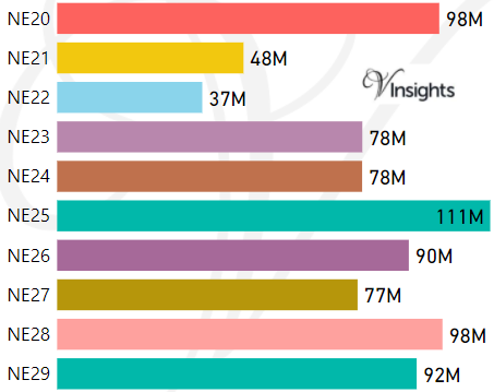
- M represents Million Pounds
- Total value includes Property Type Other apart from Detached, Semi-Detached, Terraced, Flat/Masionette
Schools for Postcode Area NE
- NE Postcode Area - NE1, NE2, NE3, NE4, NE5, NE6, NE7, NE8, NE9 School Details
- NE Postcode Area - NE10, NE11, NE12, NE13, NE15, NE16, NE17, NE18, NE19 School Details
- NE Postcode Area - NE20, NE21, NE22, NE23, NE24, NE25, NE26, NE27, NE28, NE29 School Details
- NE Postcode Area - NE30, NE31, NE32, NE33, NE34, NE35, NE36, NE37, NE38, NE39 School Details
- NE Postcode Area - NE40, NE41, NE42, NE43, NE44, NE45, NE46, NE47, NE48, NE49 School Details
- NE Postcode Area - NE61, NE62, NE63, NE64, NE65, NE66, NE67, NE68, NE69, NE70, NE71 School Details
Property Posts for Postcode Area NE
88ee67d6-4aaa-4dee-9d4a-08bd19242702|0|.0|27604f05-86ad-47ef-9e05-950bb762570c
Tags :