|
|
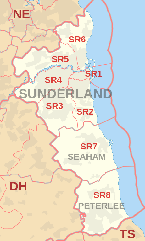
| Postcode |
Coverage Area |
Local Authority Area |
| SR1 |
Sunderland City Centre, East End, Hendon (north of Egerton Street) |
Sunderland |
| SR2 |
Ashbrooke, Ryhope, Grangetown, Hendon (south of Salisbury Street), Hillview, Thornhill |
Sunderland |
| SR3 |
Chapelgarth, Doxford Park, Farringdon, Elstob Farm, Essen Way, Gilley Law, Hall Farm, Herrington, Humbledon Hill, Mill Hill, Moorside, Plains Farm, Ryhope, Silksworth, Springwell Village, Thorney Close, Tunstall |
Sunderland |
| SR4 |
Ayres Quay, Barnes, Chester Road, Deptford, Ford Estate, Grindon, Hastings Hill, Hylton Lane Estate, High Barnes, Millfield, Tyne and Wear, Pallion, Ford Estate, Pennywell, South Hylton |
Sunderland |
| SR5 |
Carley Hill, Castletown, Downhill, Fulwell (west of Metro line), Hylton Castle, Hylton Red House, Marley Pots, Monkwearmouth (west of Metro line), Sheepfolds, Southwick, Town End Farm, Witherwack |
Sunderland |
| SR6 |
Cleadon, Fulwell (east of Metro line), Monkwearmouth (east of Metro line), North Haven, Roker, St Peter's Riverside, Seaburn, Seaburn Dene, South Bents, Whitburn |
Sunderland, South Tyneside |
| SR7 |
Cold Hesledon, Dalton-le-Dale, Dawdon, Deneside, Greenhill, Murton, Northlea, Parkside, Seaham, West Lea |
County Durham |
| SR8 |
Easington, Easington Colliery, Horden, Little Thorpe, Peterlee |
County Durham |