13. April 2018 16:07
/
VInsights Team
/
/
Comments (0)
Please click here for the updated version of this post
This Post covers
Coverage Area of Postcode FY1 to FY8
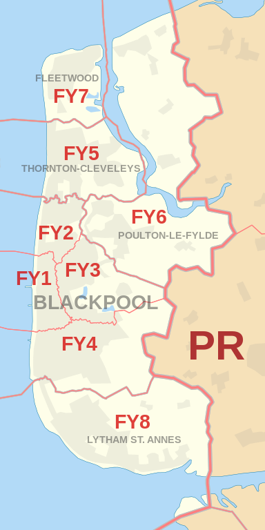 |
| Postcode |
Coverage Area |
Local Authority Area |
| FY1 |
Blackpool, North Shore |
Blackpool |
| FY2 |
Bispham |
Blackpool |
| FY3 |
Grange Park, Layton, Marton, Staining, Stanley Park |
Blackpool, Fylde, Wyre |
| FY4 |
Blackpool, Marton, South Shore, Squires Gate, Starr Gate |
Blackpool, Fylde |
| FY5 |
Blackpool, Anchorsholme, Little Bispham, Thornton-Cleveleys |
Blackpool, Wyre |
| FY6 |
Poulton-le-Fylde, Hambleton, Knott End-on-Sea,
Preesall, Singleton, Stalmine |
Wyre, Fylde |
| FY7 |
Fleetwood |
Wyre |
| FY8 |
Lytham St. Annes, Moss Side |
Fylde |
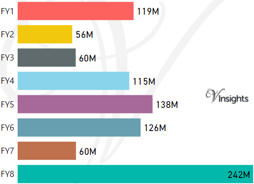
- M represents Million Pounds
- Total value includes Property Type Other apart from Detached, Semi-Detached, Terraced, Flat/Masionette
Schools for Postcode Area FY
Property Posts for Postcode Area FY
c20b595b-1940-46a5-bf4c-70b6b71e6ce7|0|.0|27604f05-86ad-47ef-9e05-950bb762570c
Tags :
13. April 2018 15:46
/
VInsights Team
/
/
Comments (0)
Please click here for the updated version of this post
This Post covers
Coverage Area of Postcode CW1 to CW12
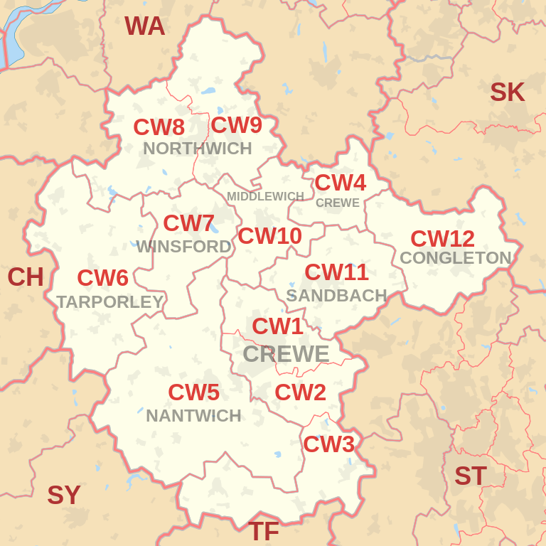 |
| Postcode |
Coverage Area |
Local Authority Area |
| CW1 |
Crewe, Haslington, Leighton |
Cheshire East |
| CW2 |
Crewe, Wistaston, Woolstanwood |
Cheshire East |
| CW3 |
Crewe, Madeley, Betley, Woore, Audlem |
Cheshire East,
Newcastle-under-Lyme,
Shropshire |
| CW4 |
Holmes Chapel, Goostrey, Cranage |
Cheshire East |
| CW5 |
Nantwich, Willaston, Sound |
Cheshire East |
| CW6 |
Tarporley, Winsford Rural West |
Cheshire West and Chester |
| CW7 |
Winsford (Town), Wharton, Over, Glebe Green,
Darnhall, Stanthorne, Bostock, Wimboldsley |
Cheshire West and Chester |
| CW8 |
Northwich, Hartford, Weaverham, Castle, Greenbank |
Cheshire West and Chester |
| CW9 |
Northwich, Wincham, Lostock Gralam, Rudheath,
Leftwich, Davenham, Kingsmead, Antrobus |
Cheshire West and Chester |
| CW10 |
Middlewich, Winsford Rural East |
Cheshire East |
| CW11 |
Sandbach, Ettiley Heath, Elworth, Wheelock |
Cheshire East |
| CW12 |
Congleton, North Rode |
Cheshire East |

- M represents Million Pounds
- Total value includes Property Type Other apart from Detached, Semi-Detached, Terraced, Flat/Masionette
Schools for Postcode Area CW
- CW Postcode Area - CW1, CW2, CW3, CW4, CW5, CW6, CW7, CW8, CW9, CW10, CW11, CW12 School Details
Property Posts for Postcode Area CW
33d4e767-9555-433a-aa20-6e31ecbe22b8|0|.0|27604f05-86ad-47ef-9e05-950bb762570c
Tags :
13. April 2018 14:48
/
VInsights Team
/
/
Comments (0)
Please click here for the updated version of this post
This Post covers
Coverage Area of Postcode CH60 to CH66
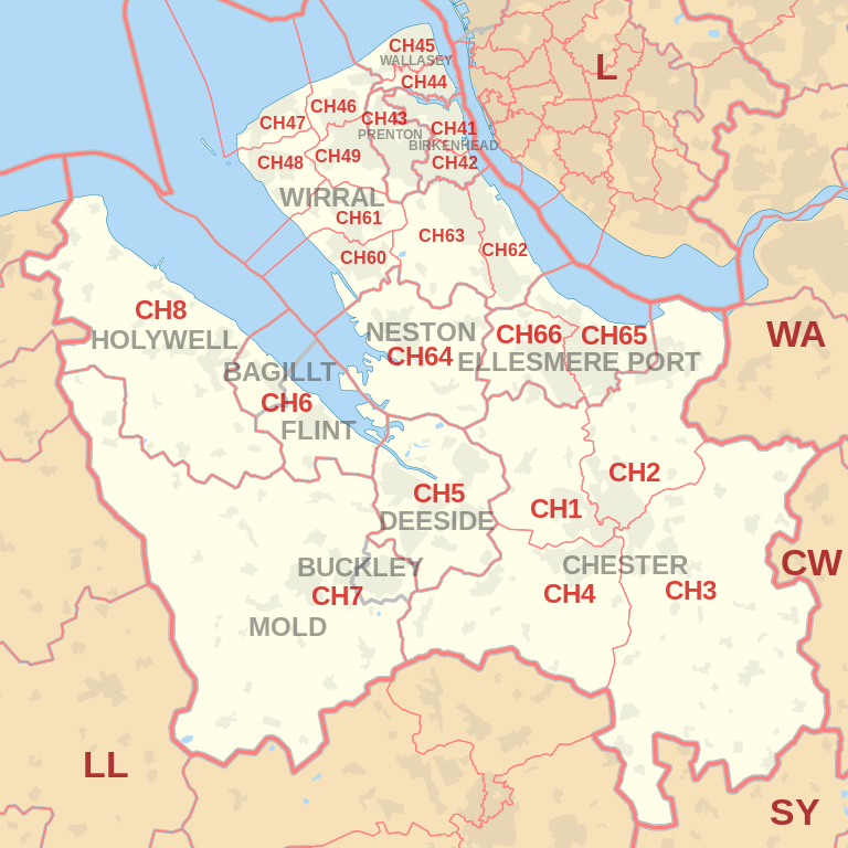 |
| Postcode |
Coverage Area |
Local Authority Area |
| CH60 |
Gayton, Heswall |
Wirral |
| CH61 |
Barnston, Heswall, Irby, Pensby, Thingwall, Thurstaston |
Wirral |
| CH62 |
Bromborough, Eastham, New Ferry, Port Sunlight, Spital |
Wirral |
| CH63 |
Bebington, Brimstage, Bromborough, Clatterbridge,
Higher Bebington, Raby, Raby Mere, Spital, Storeton, Thornton Hough |
Wirral |
| CH64 |
Little Neston, Ness, Neston, Parkgate, Puddington, Willaston |
Cheshire West and Chester |
| CH65 |
Ellesmere Port, Great Sutton, Whitby, Wolverham |
Cheshire West and Chester |
| CH66 |
Childer Thornton, Ellesmere Port, Great Sutton, Hooton, Ledsham, Little Sutton, Overpool, Whitby |
Cheshire West and Chester |
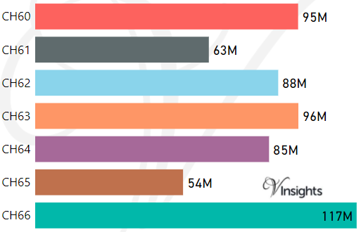
- M represents Million Pounds
- Total value includes Property Type Other apart from Detached, Semi-Detached, Terraced, Flat/Masionette
Schools for Postcode Area CH
- CH Postcode Area - CH1, CH2, CH3, CH4, CH5, CH6, CH7, CH8 School Details
- CH Postcode Area - CH41, CH42, CH43, CH44, CH45, CH46, CH47, CH48, CH49 School Details
- CH Postcode Area - CH60, CH61, CH62, CH63, CH64, CH65, CH66 School Details
Property Posts for Postcode Area CH
7786a4b2-97e0-4dee-9a68-ca8d04e7da8e|0|.0|27604f05-86ad-47ef-9e05-950bb762570c
Tags :
12. April 2018 22:55
/
VInsights Team
/
/
Comments (0)
Please click here for the updated version of this post
This Post covers
Coverage Area of Postcode CH41 to CH49
|
| Postcode |
Coverage Area |
Local Authority Area |
| CH41 |
Birkenhead, Claughton, Seacombe, Tranmere, Woodside |
Wirral |
| CH42 |
Birkenhead, Oxton, Prenton, Rock Ferry |
Wirral |
| CH43 |
Beechwood, Bidston, Noctorum, Oxton, Prenton |
Wirral |
| CH44 |
Egremont, Liscard, Poulton, Seacombe, Wallasey |
Wirral |
| CH45 |
New Brighton, Wallasey, Wallasey Village |
Wirral |
| CH46 |
Leasowe, Moreton |
Wirral |
| CH47 |
Hoylake, Meols, Saughall Massie, West Kirby |
Wirral |
| CH48 |
Caldy, Frankby, Grange, Greasby, Hoylake, Meols, Newton, West Kirby |
Wirral |
| CH49 |
Greasby, Landican, Saughall Massie, Upton, Woodchurch |
Wirral |
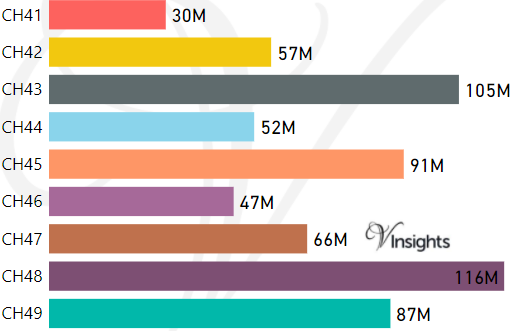
- M represents Million Pounds
- Total value includes Property Type Other apart from Detached, Semi-Detached, Terraced, Flat/Masionette
Schools for Postcode Area CH
- CH Postcode Area - CH1, CH2, CH3, CH4, CH5, CH6, CH7, CH8 School Details
- CH Postcode Area - CH41, CH42, CH43, CH44, CH45, CH46, CH47, CH48, CH49 School Details
- CH Postcode Area - CH60, CH61, CH62, CH63, CH64, CH65, CH66 School Details
Property Posts for Postcode Area CH
4eee121c-ae6d-4e0a-b480-f3ae6e39d8a0|0|.0|27604f05-86ad-47ef-9e05-950bb762570c
Tags :
12. April 2018 22:46
/
VInsights Team
/
/
Comments (0)
Please click here for the updated version of this post
This Post covers
Coverage Area of Postcode CH1 to CH8
|
| Postcode |
Coverage Area |
Local Authority Area |
| CH1 |
Blacon, Chester, Higher Ferry, Capenhurst, Backford |
Cheshire West and Chester,
Flintshirel |
| CH2 |
Backford, Chester, Elton, Hoole, Ince, Mickle Trafford,
Moston, Newton by Chester, Upton by Chester |
Cheshire West and Chester |
| CH3 |
Boughton, Chester, Huntington, Mouldsworth,Tarvin,
Tattenhall, Farndon, Waverton,Saighton,Upton by Chester |
Cheshire West and Chester |
| CH4 |
Chester, Curzon Park, Handbridge, Lache, Pulford,
Penyffordd, Broughton, Saltney |
Cheshire West and Chester,
Flintshire |
| CH5 |
Connah's Quay, Shotton, Queensferry, Sealand,
Garden City, Sandycroft, Hawarden, Ewloe, Mancot |
Flintshire |
| CH6 |
Flint, Oakenholt, Flint Mountain, The Nant, Bagillt |
Flintshire |
| CH7 |
Buckley, Leeswood, Treuddyn, Llanarmon-yn-Ial,
Caerwys, Mold, Northop Hall, Drury |
Flintshire,
Denbighshire |
| CH8 |
Holywell, Milwr, Holway, Carmel, Lloc, Bryn Celyn,
Greenfield, Halkyn, Lixwm, Talacre |
Flintshire |

- M represents Million Pounds
- Total value includes Property Type Other apart from Detached, Semi-Detached, Terraced, Flat/Masionette
Schools for Postcode Area CH
- CH Postcode Area - CH1, CH2, CH3, CH4, CH5, CH6, CH7, CH8 School Details
- CH Postcode Area - CH41, CH42, CH43, CH44, CH45, CH46, CH47, CH48, CH49 School Details
- CH Postcode Area - CH60, CH61, CH62, CH63, CH64, CH65, CH66 School Details
Property Posts for Postcode Area CH
eac26f10-2e74-4561-8086-dc0737b35d08|0|.0|27604f05-86ad-47ef-9e05-950bb762570c
Tags :