12. April 2018 22:35
/
VInsights Team
/
/
Comments (0)
Please click here for the updated version of this post
This Post covers
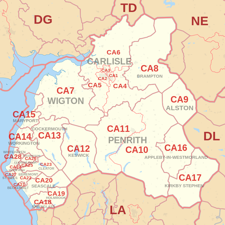
Coverage Area of Postcode CA20 to CA28
 |
| Postcode |
Coverage Area |
Local Authority Area |
| CA20 |
Seascale, Sellafield, Gosforth & Wasdale Head |
Copeland |
| CA21 |
Beckermet |
Copeland |
| CA22 |
Egremont & Thornhill |
Copeland |
| CA23 |
Ennerdale Bridge |
Copeland |
| CA24 |
Moor Row |
Copeland |
| CA25 |
Cleator Moor |
Copeland |
| CA26 |
Frizington & Croasdale |
Copeland |
| CA27 |
St. Bees |
Copeland |
| CA28 |
Whitehaven, Sandwith & Hensingham |
Copeland |
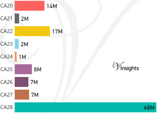
- M represents Million Pounds
- Total value includes Property Type Other apart from Detached, Semi-Detached, Terraced, Flat/Masionette
Schools for Postcode Area CA
- CA Postcode Area - CA1, CA2, CA3, CA4, CA5, CA6, CA7, CA8, CA9 School Details
- CA Postcode Area - CA10, CA11, CA12, CA13, CA14, CA15, CA16, CA17, CA18, CA19 School Details
- CA Postcode Area - CA20, CA21, CA22, CA23, CA24, CA25, CA26, CA27, CA28 School Details
Property Posts for Postcode Area CA
9c3ae702-df7e-4bd3-bcab-3159d23c28f9|0|.0|27604f05-86ad-47ef-9e05-950bb762570c
Tags :
12. April 2018 22:27
/
VInsights Team
/
/
Comments (0)
Please click here for the updated version of this post
This Post covers
Coverage Area of Postcode CA10 to CA19
|
| Postcode |
Coverage Area |
Local Authority Area |
| CA10 |
Penrith Carleton Hall area, Shap, Tebay,
Kirkby Thore, Langwathby, Lazonby & Pooley Bridge |
Eden, South Lakeland |
| CA11 |
Penrith (most), Stainton, Mungrisdale, Glenridding & Patterdale |
Eden |
| CA12 |
Keswick, Seatoller, Braithwaite, Bassenthwaite & Threlkeld |
Allerdale, Eden |
| CA13 |
Cockermouth, Lorton & Buttermere |
Allerdale |
| CA14 |
Workington, Distington, Stainburn & Seaton |
Allerdale, Copeland |
| CA15 |
Maryport, Dearham, Flimby & Allonby |
Allerdale |
| CA16 |
Appleby-in-Westmorland |
Eden |
| CA17 |
Kirkby Stephen, Brough & Ravenstonedale |
Eden, South Lakeland |
| CA18 |
Ravenglass |
Copeland |
| CA19 |
Holmrook, Santon Bridge & Eskdale |
Copeland |

- M represents Million Pounds
- Total value includes Property Type Other apart from Detached, Semi-Detached, Terraced, Flat/Masionette
Schools for Postcode Area CA
- CA Postcode Area - CA1, CA2, CA3, CA4, CA5, CA6, CA7, CA8, CA9 School Details
- CA Postcode Area - CA10, CA11, CA12, CA13, CA14, CA15, CA16, CA17, CA18, CA19 School Details
- CA Postcode Area - CA20, CA21, CA22, CA23, CA24, CA25, CA26, CA27, CA28 School Details
Property Posts for Postcode Area CA
deae4a48-807d-4c7c-9a2d-fea254c45010|0|.0|27604f05-86ad-47ef-9e05-950bb762570c
Tags :
12. April 2018 22:18
/
VInsights Team
/
/
Comments (0)
Please click here for the updated version of this post
This Post covers
Coverage Area of Postcode CA1 to CA9
|
| Postcode |
Coverage Area |
Local Authority Area |
| CA1 |
Carlisle East |
City of Carlisle |
| CA2 |
Carlisle South West |
City of Carlisle |
| CA3 |
Carlisle North |
City of Carlisle |
| CA4 |
Warwick Bridge, Wetheral, Cumwhinton & Armathwaite |
City of Carlisle, Eden |
| CA5 |
Dalston and Burgh by Sands |
City of Carlisle, Allerdale |
| CA6 |
Longtown, Bewcastle |
City of Carlisle |
| CA7 |
Wigton, Silloth, Aspatria, Caldbeck & Hesket Newmarket |
Allerdale, Eden |
| CA8 |
Brampton, Gilsland, Greenhead & Slaggyford |
City of Carlisle, Northumberland |
| CA9 |
Alston, Garrigill & Nenthead |
Eden, Northumberland |

- M represents Million Pounds
- Total value includes Property Type Other apart from Detached, Semi-Detached, Terraced, Flat/Masionette
Schools for Postcode Area CA
- CA Postcode Area - CA1, CA2, CA3, CA4, CA5, CA6, CA7, CA8, CA9 School Details
- CA Postcode Area - CA10, CA11, CA12, CA13, CA14, CA15, CA16, CA17, CA18, CA19 School Details
- CA Postcode Area - CA20, CA21, CA22, CA23, CA24, CA25, CA26, CA27, CA28 School Details
Property Posts for Postcode Area CA
5880372f-a531-44bb-9393-f09fa55a8fa9|0|.0|27604f05-86ad-47ef-9e05-950bb762570c
Tags :
12. April 2018 21:15
/
VInsights Team
/
/
Comments (0)
Please click here for the updated version of this post
This Post covers
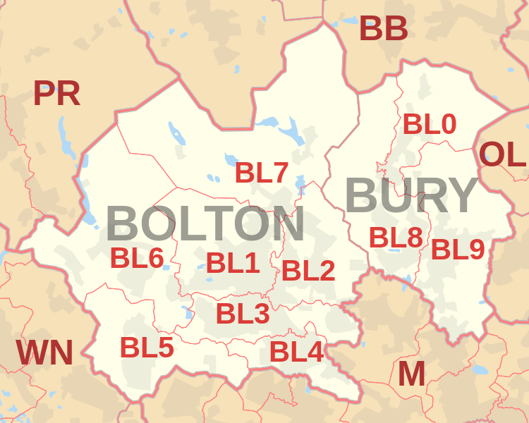
Coverage Area of Postcode BL0 to BL9
 |
| Postcode |
Coverage Area |
Local Authority Area |
| BL0 |
Bury, Ramsbottom, Edenfield, Shuttleworth |
Bury, Rossendale |
| BL1 |
Bolton, Smithills, Halliwell, Heaton |
Bolton |
| BL2 |
Bolton, Ainsworth, Bradley Fold, Bradshaw,
Breightmet, Harwood, Tonge Fold, Tonge Moor |
Bolton, Bury |
| BL3 |
Bolton, Little Lever, Great Lever, Darcy Lever |
Bolton |
| BL4 |
Bolton, Farnworth, Kearsley |
Bolton |
| BL5 |
Bolton, Over Hulton, Westhoughton |
Bolton |
| BL6 |
Bolton, Blackrod, Horwich, Lostock, Rivington |
Bolton, Chorley |
| BL7 |
Bolton, Belmont, Bromley Cross, Chapeltown,
Edgworth, Egerton, Turton |
Blackburn With Darwen, Bolton |
| BL8 |
Bury, Brandlesholme, Greenmount, Affetside,
Hawkshaw, Holcombe, Ramsbottom, Tottington, Walshaw |
Bury |
| BL9 |
Bury, Heap, Heap Bridge, Nangreaves, Summerseat,
Unsworth, Walmersley, Bircle, Jericho |
Bury |
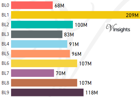
- M represents Million Pounds
- Total value includes Property Type Other apart from Detached, Semi-Detached, Terraced, Flat/Masionette
Schools for Postcode Area BL
Property Posts for Postcode Area BL
cf40b9fb-6c99-4e5a-9317-1b75f634dbab|0|.0|27604f05-86ad-47ef-9e05-950bb762570c
Tags :
12. April 2018 20:46
/
VInsights Team
/
/
Comments (0)
Please click here for the updated version of this post
This Post covers
Coverage Area of Postcode BB10 to BB18
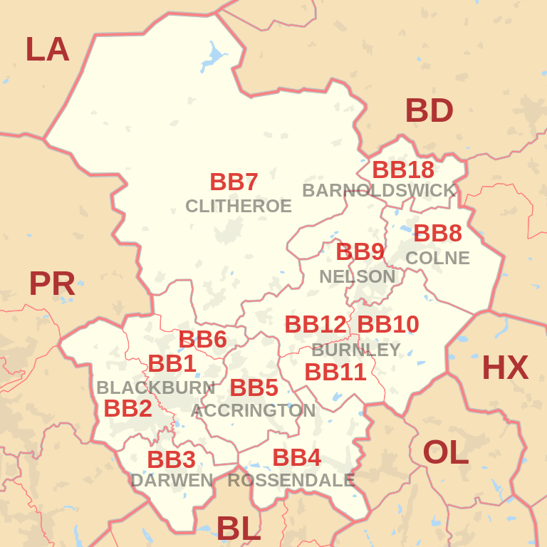 |
| Postcode |
Coverage Area |
Local Authority Area |
| BB10 |
Burnley (east), Cliviger, Haggate, Harle Syke, Reedley, Worsthorne |
Burnley, Pendle |
| BB11 |
Burnley (south and town centre), Dunnockshaw and Clowbridge, Hapton |
Burnley |
| BB12 |
Burnley (west), Barley, Fence, Hapton, Higham,
Padiham, Read, Simonstone, Wheatley Lane |
Burnley, Pendle, Ribble Valley |
| BB18 |
Barnoldswick, Bracewell and Brogden, Earby, Kelbrook, Salterforth, Sough |
Pendle |
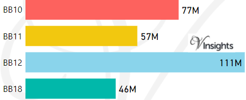
- M represents Million Pounds
- Total value includes Property Type Other apart from Detached, Semi-Detached, Terraced, Flat/Masionette
Schools for Postcode Area BB
- BB Postcode Area - BB1, BB2, BB3, BB4, BB5, BB6, BB7, BB8, BB9 School Details
- BB Postcode Area - BB10, BB11, BB12, BB18 School Details
Property Posts for Postcode Area BB
7fdae548-8282-428e-a349-dd30000560cf|0|.0|27604f05-86ad-47ef-9e05-950bb762570c
Tags :