14. April 2018 17:37
/
VInsights Team
/
/
Comments (0)
Please click here for the updated version of this post
This Post covers
Coverage Area of Postcode M20 to M29
 |
| Postcode |
Coverage Area |
Local Authority Area |
| M20 |
Didsbury, Withington |
Manchester |
| M21 |
Chorlton-cum-Hardy, Barlow Moor |
Manchester |
| M22 |
Wythenshawe, Northenden, Sharston Industrial Area |
Manchester |
| M23 |
Baguley, Brooklands, Roundthorn Industrial Estate |
Manchester |
| M24 |
Middleton, Alkrington, Chadderton |
Rochdale, Oldham |
| M25 |
Prestwich, Sedgeley Park, Simister |
Bury |
| M26 |
Radcliffe, Stoneclough |
Bury, Bolton |
| M27 |
Swinton, Clifton, Pendlebury, Wardley, Agecroft |
Salford |
| M28 |
Worsley, Walkden, Boothstown, Mosley Common, Wardley Industrial Estate |
Salford, Wigan |
| M29 |
Tyldesley, Astley |
Wigan |
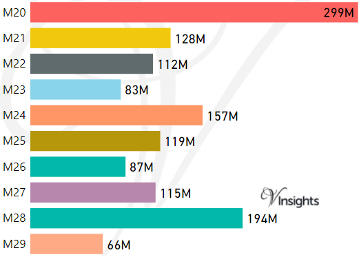
- M represents Million Pounds
- Total value includes Property Type Other apart from Detached, Semi-Detached, Terraced, Flat/Masionette
Schools for Postcode Area M
- M Postcode Area - M1, M2, M3, M4, M5, M6, M7, M8, M9 School Details
- M Postcode Area - M11, M12, M13, M14, M15, M16, M17, M18, M19 School Details
- M Postcode Area - M20, M21, M22, M23, M24, M25, M26, M27, M28, M29 School Details
- M Postcode Area - M30, M31, M32, M33, M34, M35, M38 School Details
- M Postcode Area - M40, M41, M43, M44, M45, M46, M50 School Details
Property Posts for Postcode Area M
18ef3134-340d-4985-8464-2da99056f767|0|.0|27604f05-86ad-47ef-9e05-950bb762570c
Tags :
14. April 2018 17:29
/
VInsights Team
/
/
Comments (0)
Please click here for the updated version of this post
This Post covers
Coverage Area of Postcode M11 to M19
|
| Postcode |
Coverage Area |
Local Authority Area |
| M11 |
Clayton, Openshaw, Beswick |
Manchester |
| M12 |
Ardwick, Longsight, Chorlton-on-Medlock |
Manchester |
| M13 |
Ardwick, Longsight, Chorlton-on-Medlock |
Manchester |
| M14 |
Fallowfield, Moss Side, Ladybarn, Rusholme, Victoria Park |
Manchester |
| M15 |
Hulme, Manchester Science Park |
Manchester |
| M16 |
Firswood, Old Trafford, Whalley Range, Moss Side |
Manchester, Trafford |
| M17 |
Trafford Park, The Trafford Centre |
Trafford |
| M18 |
Abbey Hey, Gorton |
Manchester |
| M19 |
Levenshulme, Burnage, Heaton Mersey, Heaton Chapel, Reddish |
Manchester, Stockport |
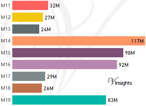
- M represents Million Pounds
- Total value includes Property Type Other apart from Detached, Semi-Detached, Terraced, Flat/Masionette
Schools for Postcode Area M
- M Postcode Area - M1, M2, M3, M4, M5, M6, M7, M8, M9 School Details
- M Postcode Area - M11, M12, M13, M14, M15, M16, M17, M18, M19 School Details
- M Postcode Area - M20, M21, M22, M23, M24, M25, M26, M27, M28, M29 School Details
- M Postcode Area - M30, M31, M32, M33, M34, M35, M38 School Details
- M Postcode Area - M40, M41, M43, M44, M45, M46, M50 School Details
Property Posts for Postcode Area M
1f93c095-d75d-43f0-968f-932b35c4e6a8|0|.0|27604f05-86ad-47ef-9e05-950bb762570c
Tags :
14. April 2018 17:18
/
VInsights Team
/
/
Comments (0)
Please click here for the updated version of this post
This Post covers
Coverage Area of Postcode M1 to M9
|
| Postcode |
Coverage Area |
Local Authority Area |
| M1 |
Piccadilly, City Centre, Market Street |
Manchester |
| M2 |
Deansgate, City Centre |
Manchester |
| M3 |
City Centre, Deansgate, Castlefield, Blackfriars, Greengate, Trinity |
Manchester, Salford |
| M4 |
Ancoats, Northern Quarter, Strangeways |
Manchester |
| M5 |
Ordsall, Seedley, Weaste, University |
Salford |
| M6 |
Pendleton, Irlams o' th' Height, Langworthy, Seedley, Charlestown |
Salford |
| M7 |
Higher Broughton, Cheetwood, Lower Broughton, Kersal |
Salford |
| M8 |
Crumpsall, Cheetham Hill |
Manchester |
| M9 |
Harpurhey, Blackley |
Manchester |
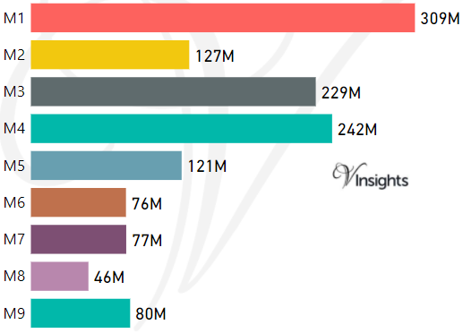
- M represents Million Pounds
- Total value includes Property Type Other apart from Detached, Semi-Detached, Terraced, Flat/Masionette
Schools for Postcode Area M
- M Postcode Area - M1, M2, M3, M4, M5, M6, M7, M8, M9 School Details
- M Postcode Area - M11, M12, M13, M14, M15, M16, M17, M18, M19 School Details
- M Postcode Area - M20, M21, M22, M23, M24, M25, M26, M27, M28, M29 School Details
- M Postcode Area - M30, M31, M32, M33, M34, M35, M38 School Details
- M Postcode Area - M40, M41, M43, M44, M45, M46, M50 School Details
Property Posts for Postcode Area M
ef406b6f-1ea2-4880-9b5f-5fe7a65264b4|0|.0|27604f05-86ad-47ef-9e05-950bb762570c
Tags :
14. April 2018 16:58
/
VInsights Team
/
/
Comments (0)
Please click here for the updated version of this post
This Post covers
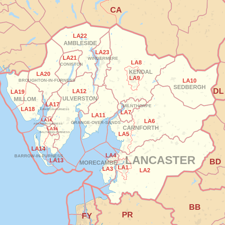
Coverage Area of Postcode LA20 to LA23
 |
| Postcode |
Coverage Area |
Local Authority Area |
| LA20 |
Broughton-in-Furness |
South Lakeland, Copeland |
| LA21 |
Coniston, Torver |
South Lakeland |
| LA22 |
Ambleside, Chapel Stile, Elterwater, Hawkshead, Near Sawrey, Skelwith Bridge |
South Lakeland |
| LA23 |
Windermere, Bowness-on-Windermere, Troutbeck |
South Lakeland |
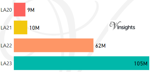
- M represents Million Pounds
- Total value includes Property Type Other apart from Detached, Semi-Detached, Terraced, Flat/Masionette
Schools for Postcode Area LA
- LA Postcode Area - LA1, LA2, LA3, LA4, LA5, LA6, LA7, LA8, LA9 School Details
- LA Postcode Area -LA10, LA11, LA12, LA13, LA14, LA15, LA16, LA17, LA18, LA19 School Details
- LA Postcode Area - LA20, LA21, LA22, LA23 School Details
Property Posts for Postcode Area LA
091efeb7-0ebe-4660-86ad-139338fe9ed1|0|.0|27604f05-86ad-47ef-9e05-950bb762570c
Tags :
14. April 2018 16:49
/
VInsights Team
/
/
Comments (0)
Please click here for the updated version of this post
This Post covers
Coverage Area of Postcode LA10 to LA19
|
| Postcode |
Coverage Area |
Local Authority Area |
| LA10 |
Sedbergh, Dent |
South Lakeland, Craven, Eden |
| LA11 |
Grange-over-Sands, Allithwaite, Cark, Cartmel,
Field Broughton, High Newton, Lindale, Low Newton,
Meathop and Ulpha, Witherslack |
South Lakeland |
| LA12 |
Ulverston, Aldingham, Backbarrow, Gleaston,
Haverthwaite, Leece, Lindal-in-Furness,
Newbiggin (Furness), Newby Bridge, Staveley-in-Cartmel, Urswick |
South Lakeland, Barrow-in-Furness |
| LA13 |
Barrow-in-Furness, Newton-in-Furness, Piel Island,
Rampside, Roa Island, Stainton with Adgarley |
Barrow-in-Furness, South Lakeland |
| LA14 |
Barrow-in-Furness, Walney Island |
Barrow-in-Furness |
| LA15 |
Dalton-in-Furness |
Barrow-in-Furness |
| LA16 |
Askam-in-Furness |
Barrow-in-Furness |
| LA17 |
Kirkby-in-Furness |
South Lakeland |
| LA18 |
Millom |
Copeland |
| LA19 |
Millom, Waberthwaite, Bootle |
Copeland |
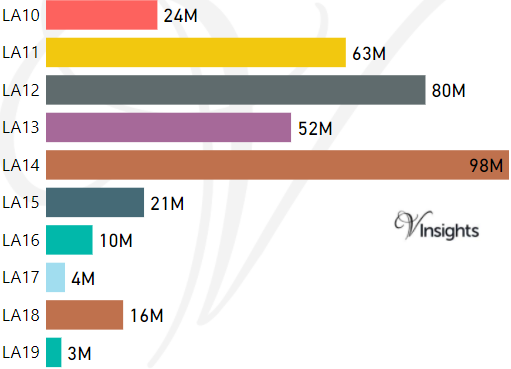
- M represents Million Pounds
- Total value includes Property Type Other apart from Detached, Semi-Detached, Terraced, Flat/Masionette
Schools for Postcode Area LA
- LA Postcode Area - LA1, LA2, LA3, LA4, LA5, LA6, LA7, LA8, LA9 School Details
- LA Postcode Area -LA10, LA11, LA12, LA13, LA14, LA15, LA16, LA17, LA18, LA19 School Details
- LA Postcode Area - LA20, LA21, LA22, LA23 School Details
Property Posts for Postcode Area LA
62f71333-71ec-4564-9905-b905633bf6f8|0|.0|27604f05-86ad-47ef-9e05-950bb762570c
Tags :