Please click here for the updated version of this post
This Post covers
- Coverage Area of Postcode PO1 to PO9
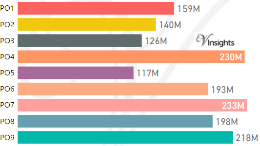
- Total Sales By Postcode PO1 to PO9
- Average & Median Sales Price By Postcode PO1 to PO9
- Total Number of Sales By Postcode PO1 to PO9
- Multi Year Property Trend Analysis By Postcode PO1 to PO9
- Property Posts for Postcode Area PO
- Schools for Postcode Area PO
Coverage Area of Postcode PO1 to PO9
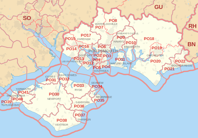 |
| Postcode |
Coverage Area |
Local Authority Area |
| PO1 |
Portsmouth, Fratton, Old Portsmouth, Portsea, Landport |
Portsmouth |
| PO2 |
Portsmouth, Hilsea, North End, Tipner, Stamshaw |
Portsmouth |
| PO3 |
Portsmouth, Hilsea, Baffins, Copnor, Anchorage Park |
Portsmouth |
| PO4 |
Southsea, Milton, Eastney |
Portsmouth |
| PO5 |
Southsea |
Portsmouth |
| PO6 |
Cosham, Drayton, Farlington |
Portsmouth |
| PO7 |
Waterlooville, Denmead, Purbrook |
Havant, Winchester |
| PO8 |
Clanfield, Cowplain, Horndean |
Havant, East Hampshire |
| PO9 |
Havant,Rowland's Castle |
Havant, East Hampshire |
Total Sales By Postcode in 2016
Average & Median Sales Price By Postcode in 2016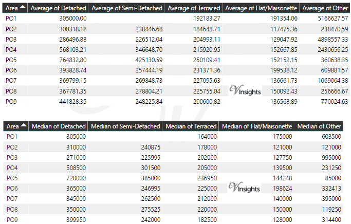
Total Number Of Sales By Postcode in 2016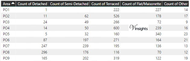
Multi Year Property Trend Analysis By Postcode
Property Posts for Postcode Area PO
Schools for Postcode Area
- PO Postcode Area - PO1, PO2, PO3, PO4, PO5, PO6, PO7, PO8, PO9 School Details
- PO Postcode Area - PO10, PO11, PO12, PO13, PO14, PO15, PO16, PO17 School Details
- PO Postcode Area - PO18, PO19, PO20, PO21, PO22 School Details
- PO Postcode Area - PO30, PO31, PO32, PO33, PO34, PO35, PO36, PO37, PO38, PO39, PO40, PO41 School Details
All PO Postcodes Yearly & Trend Analysis Posts

Reference
PO Postcode Area As Per Wikipedia
8ea574f9-3e05-4e44-a4bb-d43bb3e91269|0|.0|27604f05-86ad-47ef-9e05-950bb762570c
Tags :