16. February 2018 16:23
/
VInsights Team
/
/
Comments (0)
Please click here for the updated version of this post
This Post covers
Coverage Area of Postcode SM1 to SM7
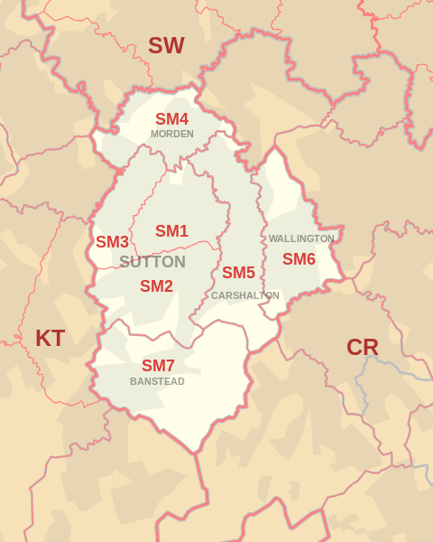 |
| Postcode |
Coverage Area |
Local Authority Area |
| SM1 |
Sutton, Rosehill, Parts of The Wrythe and Carshalton, Benhilton and Erskine Village, the eastern part of Sutton Common |
Sutton |
| SM2 |
Belmont, South Sutton, South Cheam, East Ewell |
Epsom and Ewell, Reigate and Banstead, Sutton |
| SM3 |
The western part of Sutton Common, North Cheam, Stonecot Hill |
Sutton,Merton |
| SM4 |
Morden, Morden Park, Lower Morden, St. Helier (West), Rosehill |
Merton, Sutton |
| SM5 |
Carshalton, Carshalton Beeches, Carshalton on the Hill, The Wrythe, Rosehill, St. Helier (South), Middleton Circle, Little Woodcote |
Sutton |
| SM6 |
Wallington, Beddington, Hackbridge, Roundshaw |
Sutton |
| SM7 |
Banstead, Woodmansterne, Nork, Little Woodcote |
Reigate and Banstead, Sutton |
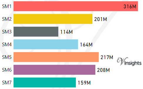
- M represents Million Pounds
- Total value includes Property Type Other apart from Detached, Semi-Detached, Terraced, Flat/Masionette
Schools for Postcode Area SM
Property Posts for Postcode Area SM
All SM Postcodes Yearly & Trend Analysis Posts

Reference
SM Postcode Area As Per Wikipedia
642ca2f6-224b-4ef6-906e-79cd570b0b34|0|.0|27604f05-86ad-47ef-9e05-950bb762570c
Tags :