Please click here for the updated version of this post
This Post covers
- Coverage Area of Postcode HU1 to HU9
- Total Sales By Postcode HU1 to HU9
- Average & Median Sales Price By Postcode HU1 to HU9
- Spread of Sales Price By Postcode HU1 to HU9
- Total Number of Sales By Postcode HU1 to HU9
- Property Posts for Postcode Area HU
- Schools for Postcode Area HU
Coverage Area of Postcode HU1 to HU9
|
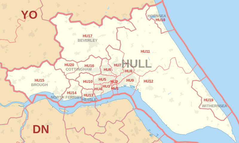
|
| Postcode |
Coverage Area |
Local Authority Area |
| HU1 |
Hull |
Kingston upon Hull |
| HU2 |
Hull |
Kingston upon Hull |
| HU3 |
Hull, Spring Bank |
Kingston upon Hull |
| HU4 |
Hull, Anlaby Common, Anlaby Park, Gipsyville |
Kingston upon Hull |
| HU5 |
Hull, The Avenues |
Kingston upon Hull |
| HU6 |
Hull, Dunswell, Orchard Park, Greenwood |
Kingston upon Hull |
| HU7 |
Hull, Bransholme, Kingswood, Sutton-on-Hull, Wawne |
Kingston upon Hull |
| HU8 |
Hull, Garden Village, Ings, Longhill, Sutton-on-Hull |
Kingston upon Hull |
| HU9 |
Hull, Drypool, Victoria Dock, Marfleet, Preston Road, Greatfield, Bilton Grange |
Kingston upon Hull |
Total Sales By Postcode
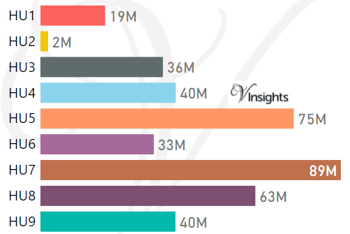
*M represents Million Pounds
Average & Median Sales Price By Postcode
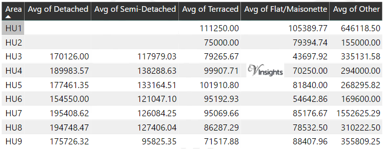
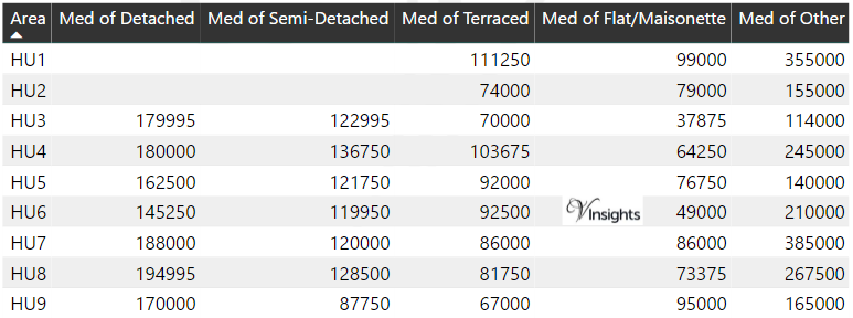
*Average and Median Sales Price are in Pounds
Spread of Sales Price By Postcode
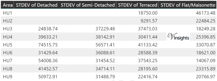
*STDEV is Standard Deviation
For example,
- Say the average detached property price for postcode XYZ is £300 K and ST. DEV. is 30 K.
- It means that most detached properties in postcode XYZ (about 68%) has price within one ST. Dev. i.e. the price range is £270K - £330K.
- All-most all detached property price (95%) in postcode XYZ lie between two ST. Dev. i.e. £240 K - £360 K
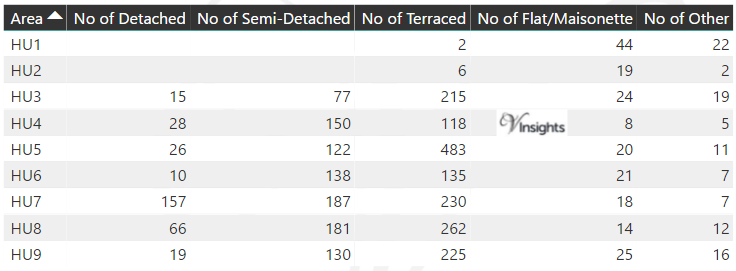
Total Number Of Sales By Postcode
Property Posts for Postcode Area HU
Schools for Postcode Area HU
- HU Postcode Area - HU1, HU2, HU3, HU4, HU5, HU6, HU7, HU8, HU9 School Details
- HU Postcode Area - HU10, HU11, HU12, HU13, HU14, HU15, HU16, HU17, HU18, HU19, HU20 School Details
All Yorkshire & Humber Postcode Area Posts

Reference
HU Postcode Area As Per Wikipedia
460973de-e7ee-416b-b2c0-d4d99d2124a1|0|.0|27604f05-86ad-47ef-9e05-950bb762570c