22. April 2018 22:16
/
VInsights Team
/
/
Comments (0)
Please click here for the updated version of this post
This Post covers
Coverage Area of Postcode HU10 to HU20
|
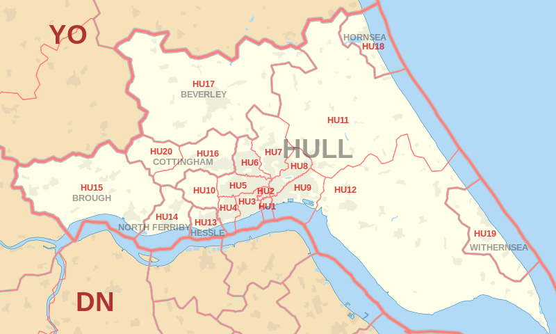
|
| Postcode |
Coverage Area |
Local Authority Area |
| HU10 |
Anlaby, Kirk Ella, West Ella, Willerby |
East Riding Of Yorkshire |
| HU11 |
Bilton |
East Riding Of Yorkshire |
| HU12 |
Hedon, Patrington, Preston |
East Riding Of Yorkshire |
| HU13 |
Hessle |
East Riding Of Yorkshire |
| HU14 |
North Ferriby, Melton, Swanland |
East Riding Of Yorkshire |
| HU15 |
Elloughton-cum-Brough, South Cave, Welton |
East Riding Of Yorkshire |
| HU16 |
Cottingham, Eppleworth, Raywell, Skidby |
East Riding Of Yorkshire |
| HU17 |
Beverley, Bishop Burton, Walkington |
East Riding Of Yorkshire |
| HU18 |
Hornsea, Mappleton, Rolston |
East Riding Of Yorkshire |
| HU19 |
Withernsea, Hollym, Holmpton,
Out Newton, Rimswell, Waxholme |
East Riding Of Yorkshire |
| HU20 |
High Hunsley, Little Weighton, Low Hunsley, Riplingham |
East Riding Of Yorkshire |

- M represents Million Pounds
- Total value includes Property Type Other apart from Detached, Semi-Detached, Terraced, Flat/Masionette
Schools for Postcode Area HU
- HU Postcode Area - HU1, HU2, HU3, HU4, HU5, HU6, HU7, HU8, HU9 School Details
- HU Postcode Area - HU10, HU11, HU12, HU13, HU14, HU15, HU16, HU17, HU18, HU19, HU20 School Details
Property Posts for Postcode Area HU
37619b4f-b34a-4f9b-831c-6e2a59dcb83a|0|.0|27604f05-86ad-47ef-9e05-950bb762570c
Tags :