Please click here for the updated version of this post
This Post covers
- Coverage Area of Postcode HG1 to HG5
- Total Sales By Postcode HG1 to HG5
- Average & Median Sales Price By Postcode HG1 to HG5
- Spread of Sales Price By Postcode HG1 to HG5
- Total Number of Sales By Postcode HG1 to HG5
- Schools for Postcode Area HG
- Property Posts for Postcode Area HG
Coverage Area of Postcode HG1 to HG5
|

|
| Postcode |
Coverage Area |
Local Authority Area |
| HG1 |
Central, Bilton, Jennyfields, Duchy, New Park |
Harrogate |
| HG2 |
Oatlands, Woodlands, Hookstone, Rossett,
Pannal Ash, Harlow Hill, Hornbeam Park |
Harrogate |
| HG3 |
Pannal, Killinghall, Spofforth, Bishop Monkton,
Glasshouses, Follifoot, Pateley Bridge |
Harrogate |
| HG4 |
Ripon, North Stainley, High Grantley, Masham,
West Tanfield, Thornton Watlass, Thornton Steward |
Harrogate, Hambleton,
Richmondshire |
| HG5 |
Scotton, Knaresborough |
Harrogate |
Total Sales By Postcode
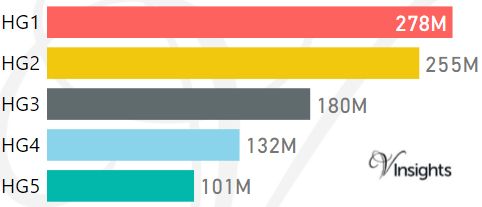
*M represents Million Pounds
Average & Median Sales Price By Postcode
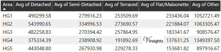
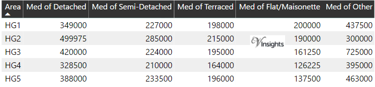
*Average and Median Sales Price are in Pounds
Spread of Sales Price By Postcode
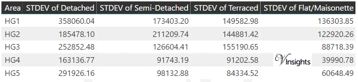
*STDEV is Standard Deviation
For example,
- Say the average detached property price for postcode XYZ is £300 K and ST. DEV. is 30 K.
- It means that most detached properties in postcode XYZ (about 68%) has price within one ST. Dev. i.e. the price range is £270K - £330K.
- All-most all detached property price (95%) in postcode XYZ lie between two ST. Dev. i.e. £240 K - £360 K
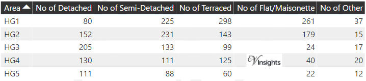
Total Number Of Sales By Postcode
Schools for Postcode Area HG
Property Posts for Postcode Area HG
All Yorkshire & Humber Postcode Area Posts

Reference
HG Postcode Area As Per Wikipedia
4070813b-dd8e-4d63-bb91-3cf99830c862|0|.0|27604f05-86ad-47ef-9e05-950bb762570c