Please click here for the updated version of this post
This Post covers
- Coverage Area of Postcode SW1A to SW1Y
- Total Sales By Postcode SW1A to SW1Y
- Average & Median Sales Price By Postcode SW1A to SW1Y
- Total Number of Sales By Postcode SW1A to SW1Y
- Multi Year Property Trend Analysis By Postcode SW1A to SW1Y
- Schools for Postcode Area SW
- Posts for Postcode Area SW
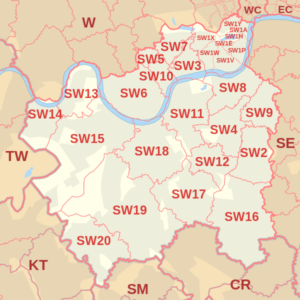
Coverage Area of Postcode SW1A to SW1Y
 |
| Postcode |
Coverage Area |
Local Authority Area |
| SW1A |
Whitehall and Buckingham Palace |
Westminster |
| SW1E |
Between Buckingham Gate and Victoria Station |
Westminster |
| SW1H |
East of Buckingham Gate |
Westminster |
| SW1P |
Triangular area between Victoria Station, the Houses of Parliament, and Vauxhall Bridge |
Westminster |
| SW1V |
Triangular area between Vauxhall Bridge, Chelsea Bridge, and Victoria Station; Pimlico proper |
Westminster |
| SW1W |
Belgravia, Chelsea (part), area between Sloane Square and Victoria Station, south of Kings Road |
Kensington and Chelsea, Westminster |
| SW1X |
Belgravia, north of Eaton Square, Knightsbridge (part), Chelsea (part) |
Kensington and Chelsea, Westminster |
| SW1Y |
St James's |
Westminster |
Total Sales By Postcode in 2016
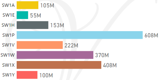
*M represents millions
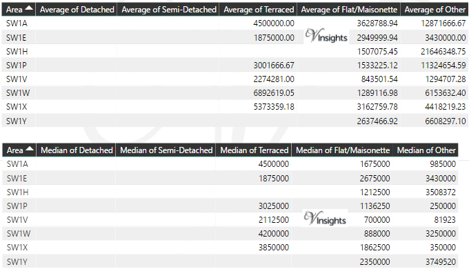
Average & Median Sales Price By Postcode in 2016
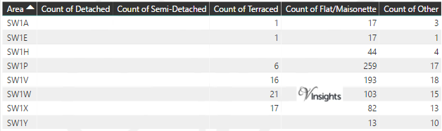
Total Number Of Sales By Postcode in 2016
Multi Year Property Trend Analysis By Postcode
Schools for Postcode Area SW
- London SW Postcode Area - SW1A, SW1E, SW1H, SW1P, SW1V, SW1W, SW1X, SW1Y School Details
- London SW Postcode Area - SW2, SW3, SW4, SW5, SW6, SW7, SW8, SW9 School Details
- London SW Postcode Area - SW10, SW11, SW12, SW13, SW14, SW15, SW16, SW17, SW18, SW19, SW20 School Details
Posts for Postcode Area SW
All SW Postcode Area Posts

Reference
SW Postcode Area As Per Wikipedia
03439a67-6f47-4026-9d2b-59b6d28202d9|0|.0|27604f05-86ad-47ef-9e05-950bb762570c