Please click here for the updated version of this post
This Post covers
- Coverage Area of Postcode CT18 to CT21
- Total Sales By Postcode CT18 to CT21
- Average & Median Sales Price By Postcode CT18 to CT21
- Total Number of Sales By Postcode CT18 to CT21
- Multi Year Property Trend Analysis By Postcode CT18 to CT21
- Schools for Postcode Area CT
- Posts For Postcode Area CT
Coverage Area of Postcode CT18 to CT21
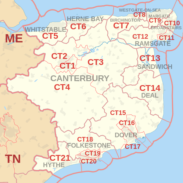 |
| Postcode |
Coverage Area |
Local Authority Area |
| CT18 |
Hawkinge, Lyminge, Etchinghill, Capel-le-Ferne, Densole, Newington |
Shepway, Dover |
| CT19 |
Folkestone (north), Cheriton |
Shepway |
| CT20 |
Folkestone (south), Sandgate |
Shepway |
| CT21 |
Hythe, Saltwood, Lympne, Postling, Newingreen, West Hythe, Westenhanger |
Shepway |
Total Sales By Postcode in 2016
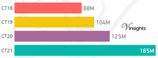
*M represent Million
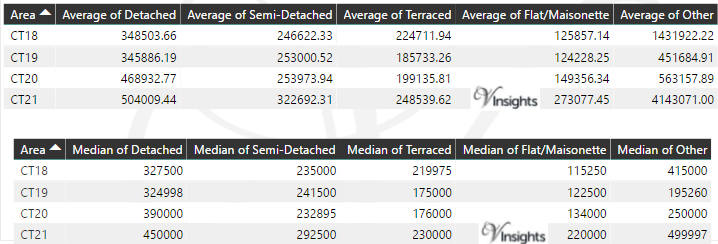
Average & Median Sales Price By Postcode in 2016
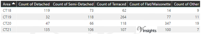
Total Number Of Sales By Postcode in2016
Multi Year Property Trend Analysis By Postcode
Schools for Postcode Area CT
- CT Postcode Area - CT1, CT2, CT3, CT4, CT5, CT6, CT7, CT8, CT9 School Details
- CT Postcode Area - CT10, CT11, CT12, CT13, CT14, CT15, CT16, CT17 School Details
- CT Postcode Area - CT18, CT19, CT20, CT21 School Details
Posts for Postcode Area CT
All South East England Postcode Area Posts

Reference
CT Postcode Area As Per Wikipedia
24341244-12fc-425c-b51f-b3a1ce748f6e|0|.0|27604f05-86ad-47ef-9e05-950bb762570c