24. April 2018 17:39
/
VInsights Team
/
/
Comments (0)
Please click here for the updated version of this post
This Post covers
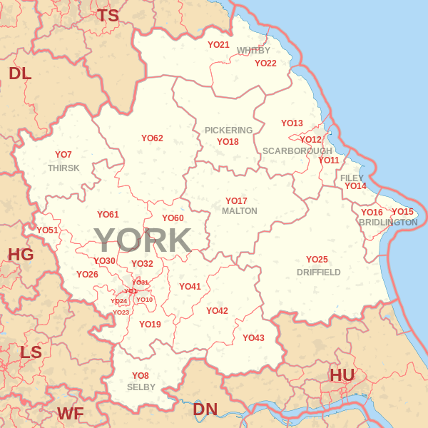
Coverage Area of Postcode YO23 to YO32
|
|
| Postcode |
Coverage Area |
Local Authority Area |
| YO23 |
South Bank, Bishopthorpe, Copmanthorpe, Rufforth |
City of York Council |
| YO24 |
Acomb, Dringhouses, Woodthorpe |
City of York Council |
| YO25 |
Driffield |
East Riding Of Yorkshire |
| YO26 |
Acomb, Leeman Road Area, Upper Poppleton, Nether Poppleton, Green Hammerton |
City of York Council |
| YO30 |
Bootham, Clifton, Skelton, Linton-on-Ouse |
City of York Council |
| YO31 |
Heworth, Huntington (South), The Groves, Layerthorpe |
City of York Council |
| YO32 |
Haxby, Huntington (North), Wigginton, New Earswick, Stockton-on-the-Forest, Strensall |
City of York Council |
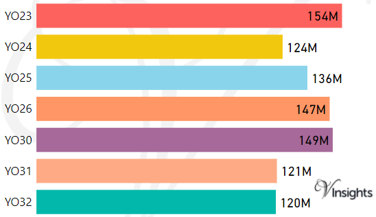
- M represents Million Pounds
- Total value includes Property Type Other apart from Detached, Semi-Detached, Terraced, Flat/Masionette
Schools for Postcode Area YO
- YO Postcode Area - YO1, YO7, YO8, YO10, YO11, YO12, YO13, YO14 School Details
- YO Postcode Area - YO15, YO16, YO17, YO18, YO19, YO21, YO22 School Details
- YO Postcode Area - YO23, YO24, YO25, YO26, YO30, YO31, YO32 School Details
- YO Postcode Area - YO41, YO42, YO43, YO51, YO60, YO61, YO62, YO90 School Details
Property Posts for Postcode Area YO
4b0f87fb-1634-452a-9301-b8f5fbb50e30|0|.0|27604f05-86ad-47ef-9e05-950bb762570c
Tags :