7. April 2018 21:28
/
VInsights Team
/
/
Comments (0)
Please click here for the updated version of this post
This Post covers
Coverage Area of Postcode NG20 to NG25
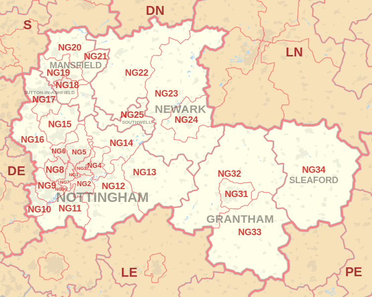 |
| Postcode |
Coverage Area |
Local Authority Area |
| NG20 |
Shirebrook, Market Warsop |
Bolsover |
| NG21 |
Rainworth, Edwinstowe, Clipstone |
Newark and Sherwood |
| NG22 |
Bilsthorpe, Newark-on-Trent |
Newark and Sherwood |
| NG23 |
Newark-on-Trent, Collingham, Long Bennington |
Newark and Sherwood |
| NG24 |
Newark-on-Trent, Balderton |
Newark and Sherwood |
| NG25 |
Southwell |
Newark and Sherwood |
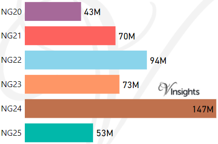
- M represents Million Pounds
- Total value includes Property Type Other apart from Detached, Semi-Detached, Terraced, Flat/Masionette
Schools for Postcode Area NG
- NG Postcode Area - NG1, NG2, NG3, NG4, NG5, NG6, NG7, NG8, NG9 School Details
- NG Postcode Area - NG10, NG11, NG12, NG13, NG14, NG15, NG16, NG17, NG18, NG19 School Details
- NG Postcode Area - NG20, NG21, NG22, NG23, NG24, NG25 School Details
- NG Postcode Area - NG31, NG32, NG33, NG34 School Details
Property Posts for Postcode Area NG
1599e6f5-8a26-4889-bd55-a7b8d4753930|0|.0|27604f05-86ad-47ef-9e05-950bb762570c
Tags :