7. April 2018 20:56
/
VInsights Team
/
/
Comments (0)
Please click here for the updated version of this post
This Post covers
Coverage Area of Postcode NG10 to NG19
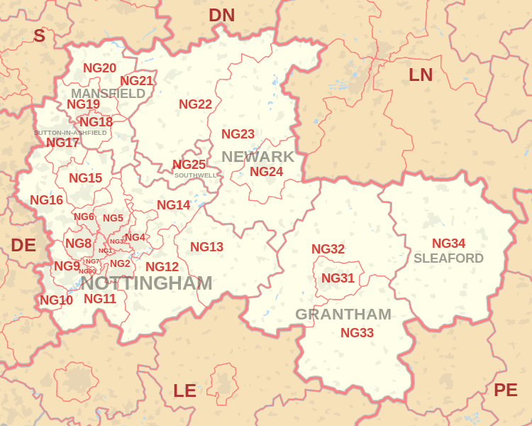 |
| Postcode |
Coverage Area |
Local Authority Area |
| NG10 |
Long Eaton, Sawley, Sandiacre |
Erewash |
| NG11 |
Clifton, Ruddington, Gotham, Kingston on Soar |
Nottingham, Rushcliffe |
| NG12 |
Cotgrave, Radcliffe on Trent, Keyworth, Edwalton |
Rushcliffe |
| NG13 |
Bingham, Whatton, Bottesford, Aslockton |
Rushcliffe, Melton |
| NG14 |
Calverton, Lowdham, Burton Joyce, Gunthorpe |
Gedling |
| NG15 |
Hucknall, Ravenshead, Newstead |
Ashfield, Gedling |
| NG16 |
Kimberley, Eastwood, Nuthall, Langley Mill, Pinxton,
Selston, Awsworth, Ironville, Jacksdale, Westwood,
Underwood, Brinsley, Watnall |
Broxtowe, Amber Valley |
| NG17 |
Sutton-in-Ashfield, Kirkby-in-Ashfield, Stanton Hill, Skegby |
Ashfield |
| NG18 |
Mansfield |
Mansfield |
| NG19 |
Mansfield Woodhouse, Forest Town |
Mansfield |
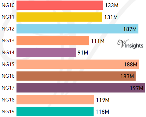
- M represents Million Pounds
- Total value includes Property Type Other apart from Detached, Semi-Detached, Terraced, Flat/Masionette
Schools for Postcode Area NG
- NG Postcode Area - NG1, NG2, NG3, NG4, NG5, NG6, NG7, NG8, NG9 School Details
- NG Postcode Area - NG10, NG11, NG12, NG13, NG14, NG15, NG16, NG17, NG18, NG19 School Details
- NG Postcode Area - NG20, NG21, NG22, NG23, NG24, NG25 School Details
- NG Postcode Area - NG31, NG32, NG33, NG34 School Details
Property Posts for Postcode Area NG
39d79767-8f0f-459f-a001-84457949be9c|0|.0|27604f05-86ad-47ef-9e05-950bb762570c
Tags :