Please click here for the updated version of this post
This Post covers
- Coverage Area of Postcode LA10 to LA19
- Total Sales By Postcode LA10 to LA19
- Average & Median Sales Price By Postcode LA10 to LA19
- Total Number of Sales By Postcode LA10 to LA19
- Other Property Posts For Postcode Area LA
- Schools for Postcode Area LA
Coverage Area of Postcode LA10 to LA19
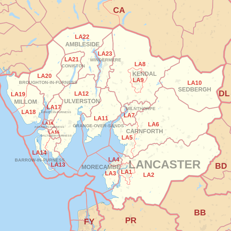 |
| Postcode |
Coverage Area |
Local Authority Area |
| LA10 |
Sedbergh, Dent |
South Lakeland, Craven, Eden |
| LA11 |
Grange-over-Sands, Allithwaite, Cark, Cartmel,
Field Broughton, High Newton, Lindale, Low Newton,
Meathop and Ulpha, Witherslack |
South Lakeland |
| LA12 |
Ulverston, Aldingham, Backbarrow, Gleaston,
Haverthwaite, Leece, Lindal-in-Furness,
Newbiggin (Furness), Newby Bridge, Staveley-in-Cartmel, Urswick |
South Lakeland, Barrow-in-Furness |
| LA13 |
Barrow-in-Furness, Newton-in-Furness, Piel Island,
Rampside, Roa Island, Stainton with Adgarley |
Barrow-in-Furness, South Lakeland |
| LA14 |
Barrow-in-Furness, Walney Island |
Barrow-in-Furness |
| LA15 |
Dalton-in-Furness |
Barrow-in-Furness |
| LA16 |
Askam-in-Furness |
Barrow-in-Furness |
| LA17 |
Kirkby-in-Furness |
South Lakeland |
| LA18 |
Millom |
Copeland |
| LA19 |
Millom, Waberthwaite, Bootle |
Copeland |
Total Sales By Postcode
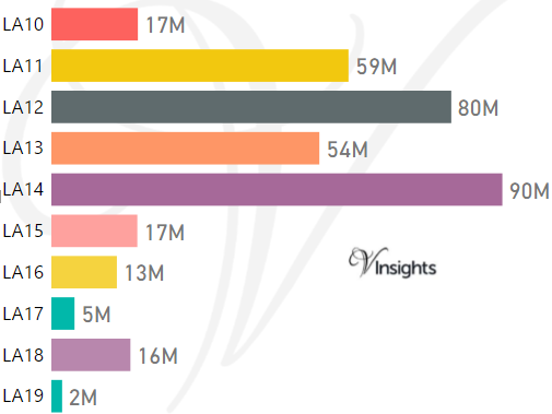
*M represent Million Pounds
Average & Median Sales Price By Postcode
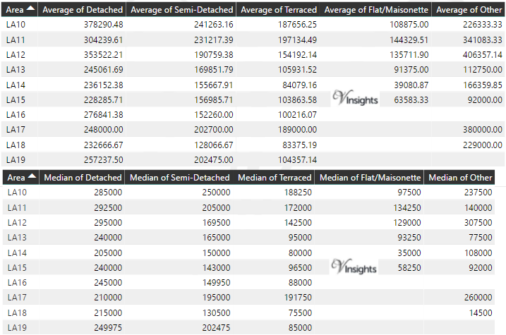
*Average and Median Sales Price are in Pounds
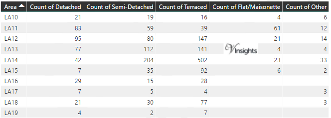
Total Number Of Sales By Postcode
Other Property Posts for Postcode Area LA
- LA Postcode Area - LA1, LA2, LA3, LA4, LA5, LA6, LA7, LA8, LA9 Property Market 2016
- LA Postcode Area - LA20, LA21, LA22, LA23 Property Market 2016
Schools for Postcode Area LA
- LA Postcode Area - LA1, LA2, LA3, LA4, LA5, LA6, LA7, LA8, LA9 School Details
- LA Postcode Area -LA10, LA11, LA12, LA13, LA14, LA15, LA16, LA17, LA18, LA19 School Details
- LA Postcode Area - LA20, LA21, LA22, LA23 School Details
All North West England Postcode Area Posts

Reference
LA Postcode Area As Per Wikipedia
e8bc2c2a-8bd4-4dcd-8c1c-9888c1e188d9|0|.0|27604f05-86ad-47ef-9e05-950bb762570c