Please click here for the updated version of this post
This Post covers
- Coverage Area of Postcode LA1 to LA9
- Total Sales By Postcode LA1 to LA9
- Average & Median Sales Price By Postcode LA1 to LA9
- Total Number of Sales By Postcode LA1 to LA9
- Property Posts For Postcode Area LA
- Schools for Postcode Area LA
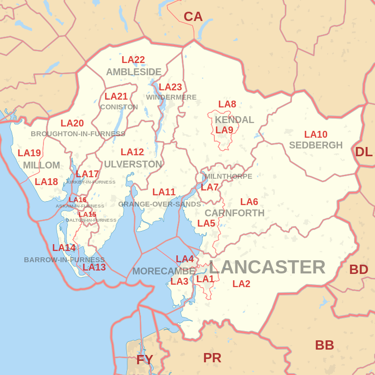
Coverage Area of Postcode LA1 to LA9
 |
| Postcode |
Coverage Area |
Local Authority Area |
| LA1 |
Lancaster, Aldcliffe, Bailrigg |
City of Lancaster |
| LA2 |
Lancaster, Abbeystead, Aldcliffe, Aughton,
Austwick, Bailrigg, Bay Horse, Caton,
Clapham, Cockerham, Dolphinholme, Ellel,
Farleton, Galgate, Glasson Dock, Halton,
Hest Bank, High Bentham, Hornby, Quernmore,
Tatham, Wharfe |
City of Lancaster, Craven |
| LA3 |
Morecambe, Heysham, Middleton, Overton, Sunderland Point |
City of Lancaster |
| LA4 |
Morecambe, Torrisholme |
City of Lancaster |
| LA5 |
Carnforth, Arnside, Silverdale, Warton, Bolton-Le-Sands |
City of Lancaster, South Lakeland |
| LA6 |
Arkholme, Burton-in-Kendal, Burton in Lonsdale,
Cantsfield, Casterton, Ingleton, Ireby, Kirkby Lonsdale,
Masongill, Tunstall, Whittington |
City of Lancaster,
Craven, South Lakeland |
| LA7 |
Milnthorpe, Beetham, Storth, Heversham |
South Lakeland,
City of Lancaster |
| LA8 |
Kendal, Brigsteer, Grayrigg, Levens, Sedgwick, Sizergh |
South Lakeland, Eden |
| LA9 |
Kendal, Burneside, Natland, Oxenholme |
South Lakeland |
Total Sales By Postcode
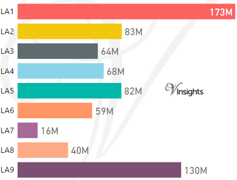
*M represent Million Pounds
Average & Median Sales Price By Postcode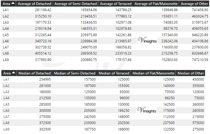
*Average and Median Sales Price are in Pounds
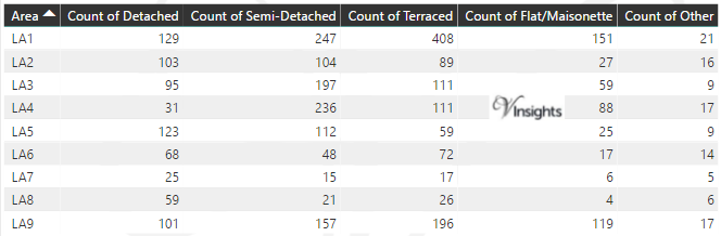
Total Number Of Sales By Postcode
Property Posts for Postcode Area LA
Schools for Postcode Area LA
- LA Postcode Area - LA1, LA2, LA3, LA4, LA5, LA6, LA7, LA8, LA9 School Details
- LA Postcode Area -LA10, LA11, LA12, LA13, LA14, LA15, LA16, LA17, LA18, LA19 School Details
- LA Postcode Area - LA20, LA21, LA22, LA23 School Details
All North West England Postcode Area Posts

Reference
LA Postcode Area As Per Wikipedia
e768b58e-ca5a-45d1-89b4-2cf6752bed69|0|.0|27604f05-86ad-47ef-9e05-950bb762570c