 |
| Postcode |
Coverage Area |
Local Authority Area |
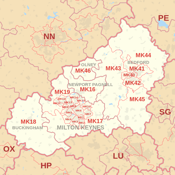
| MK40 |
Biddenham, Castle, De Parys, Great Denham, Harpur, Queens Park |
Bedford |
| MK41 |
Brickhill, Clapham, De Parys, Goldington, Harpur, Newnham, Putnoe, Renhold, Salph End |
Bedford |
| MK42 |
Castle, Cauldwell, Elstow, Harrowden, Kempston, Kingsbrook, Shortstown, Wixams |
Bedford |
| MK43 |
Bourne End, Brogborough, Box End, Bromham, Cranfield, Carlton, Felmersham, Harrold, Husborne Crawley, Keeley Green, Kempston Rural, Lidlington, Lower Shelton, Marston Moretaine, Newton Blossomville Oakley, Odell, Pavenham, Radwell, Ridgmont, Stagsden, Stevington, Stewartby, Turvey, Upper Shelton, West End, Wood End, Wootton, Wootton Green |
Bedford, Central Bedfordshire |
| MK44 |
Begwary, Bletsoe, Blunham, Bolnhurst, Cardington, Chawston, Colesden, Colmworth, Cople, Duck's Cross, Great Barford, Keysoe, Keysoe Row, Kingsbrook, Knotting, Knotting Green, Little Staughton, Melchbourne, Milton Ernest, Mogerhanger, Pertenhall, Ravensden, Riseley, Roxton, Sharnbrook, Souldrop, Swineshead, Thurleigh, Top End, Wilden, Willington, Wyboston, Yielden |
Bedford, Huntingdonshire |
| MK45 |
Ampthill, Barton-le-Clay, Clophill, Cotton End, Flitton, Flitwick, Gravenhurst, Greenfield, Haynes, Haynes Church End, Herring's Green, Houghton Conquest, How End, Kempston Hardwick, Maulden, Millbrook, Pulloxhill, Sharpenhoe, Silsoe, Steppingley, Westoning, Wilstead |
Bedford, Central Bedfordshire |
| MK46 |
Clifton Reynes, Cold Brayfield, Emberton, Lavendon, Olney, Ravenstone, Warrington, Weston Underwood |
Milton Keynes |