Please click here for the updated version of this post
This Post covers
- Coverage Area of Postcode NW1 to NW6
- Total Sales By Postcode NW1 to NW6
- Average & Median Sales Price By Postcode NW1 to NW6
- Total Number of Sales By Postcode NW1 to NW6
- Multi Year Property Trend Analysis For Postcode NW1 to NW6
- Schools for Postcode Area NW
- Posts for Postcode Area NW
Coverage Area of Postcode NW1 to NW6
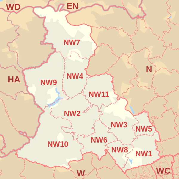 |
| Postcode |
Coverage Area |
Local Authority Area |
| NW1 |
North Western head district: Marylebone (part), Euston, Regent's Park, Baker Street, Camden Town, Somers Town, Primrose Hill (part) and Lisson Grove (part) |
Camden, Westminster |
| NW2 |
Cricklewood district: Cricklewood, Dollis Hill, Childs Hill, Golders Green (part), Brent Cross (part), Willesden (north), Neasden (north) |
Barnet, Brent, Camden |
| NW3 |
Hampstead district: Hampstead, Belsize Park, Frognal, Childs Hill (east), South Hampstead (north), Swiss Cottage (east), Primrose Hill (north), Chalk Farm (west), Gospel Oak |
Camden, Barnet |
| NW4 |
Hendon district: Hendon, Brent Cross (part) |
Barnet |
| NW5 |
Kentish Town district: Kentish Town, Camden Town (part), Gospel Oak (part), Dartmouth Park, Chalk Farm (east), Tufnell Park (west) |
Camden, Islington |
| NW6 |
Kilburn district: Kilburn, Brondesbury, West Hampstead, Queen's Park, Kensal Green (part), South Hampstead (south), Swiss Cottage (west) |
Brent, Camden, Westminster |
Total Sales By Postcode in 2016
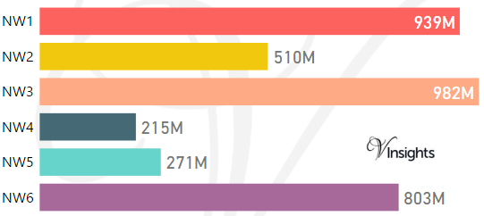
*M represents millions
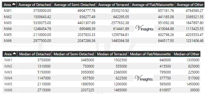
Average & Median Sales Price By Postcode in 2016
Total Number Of Sales By Postcode in 2016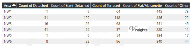
Multi Year Property Trend Analysis By Postcode
Schools for Postcode Area NW
Posts for Postcode Area NW
All NW Postcode Area Posts

Reference
NW Postcode Area As Per Wikipedia
75582197-8407-4cb1-a24a-c155ef6a9ce0|0|.0|27604f05-86ad-47ef-9e05-950bb762570c