Please click here for the updated version of this post
This Post covers
- Coverage Area of Postcode WV10 to WV16
- Total Sales By Postcode WV10 to WV16
- Average & Median Sales Price By Postcode WV10 to WV16
- Spread of Sales Price By Postcode WV10 to WV16
- Total Number of Sales By Postcode WV10 to WV16
- Other Property Posts for Postcode Area WV
- Schools for Postcode Area WV
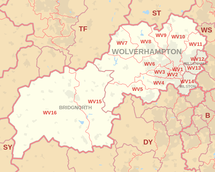
Coverage Area of Postcode WV10 to WV16
|
|
| Postcode |
Coverage Area |
Local Authority Area |
| WV10 |
Low Hill, Bushbury, Heath Town, Fordhouses, Fallings Park, Featherstone, parts of Wednesfield and Brinsford |
Wolverhampton |
| WV11 |
Wednesfield |
Wolverhampton |
| WV12 |
Short Heath, Lodge Farm |
Wolverhampton, Walsall |
| WV13 |
Shepwell Green, Willenhall Town |
Wolverhampton, Walsall |
| WV14 |
Bradley, Bilston Town, Coseley |
Wolverhampton, Dudley |
| WV15 |
Bridgnorth (Low Town) |
Shropshire |
| WV16 |
Bridgnorth (High Town), Ditton Priors |
Shropshire |
Total Sales By Postcode
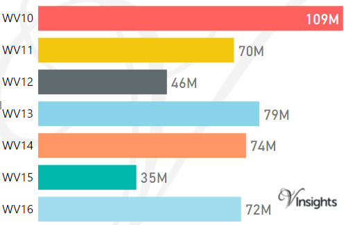
*M represents Million Pounds
Average & Median Sales Price By Postcode
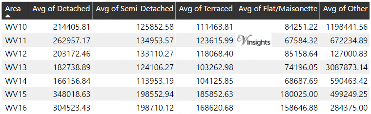
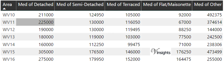
*Average and Median Sales Price are in Pounds
Spread of Sales Price By Postcode
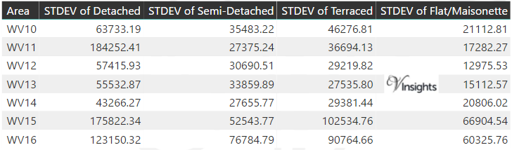
*STDEV is Standard Deviation
For example,
- Say the average detached property price for postcode XYZ is £300 K and ST. DEV. is 30 K.
- It means that most detached properties in postcode XYZ (about 68%) has price within one ST. Dev. i.e. the price range is £270K - £330K.
- All-most all detached property price (95%) in postcode XYZ lie between two ST. Dev. i.e. £240 K - £360 K
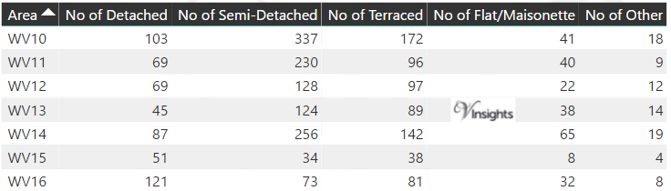
Total Number Of Sales By Postcode
Other Property Posts for Postcode Area WV
Schools for Postcode Area WV
- WV Postcode Area - WV1, WV2, WV3, WV4, WV5, WV6, WV7, WV8, WV9 School Details
- WV Postcode Area - WV10, WV11, WV12, WV13, WV14, WV15, WV16 School Details
All WV Postcodes Yearly & Trend Analysis Posts

Reference
WV Postcode Area As Per Wikipedia
aed99f14-6b3e-4e60-bdca-4ee1f609516d|0|.0|27604f05-86ad-47ef-9e05-950bb762570c