Please click here for the updated version of this post
This Post covers
- Coverage Area of Postcode SN10 to SN26
- Total Sales By Postcode SN10 to SN26
- Average & Median Sales Price By Postcode SN10 to SN26
- Total Number of Sales By Postcode SN10 to SN26
- Other Property Posts For Postcode Area SN
- Schools for Postcode Area SN
Coverage Area of Postcode SN10 to SN26
 |
| Postcode |
Coverage Area |
Local Authority Area |
| SN10 |
Devizes, Market Lavington, Rowde |
Wiltshire |
| SN11 |
Calne, Heddington, Hilmarton |
Wiltshire |
| SN12 |
Melksham, Bowerhill, Seend, Broughton Gifford |
Wiltshire |
| SN13 |
Corsham, Box, Neston |
Wiltshire |
| SN14 |
Chippenham (west), Marshfield, Kington St Michael, Hullavington, Luckington, Grittleton, Yatton Keynell, Biddestone, Colerne |
Wiltshire, South Gloucestershire |
| SN15 |
Chippenham (east), Bromham, Sandy Lane, Lacock, Burleaze, Pewsham, Monkton Park, Foxham, Dauntsey, Seagry, Christian Malford, Bradenstoke, Sutton Benger, Lyneham, Draycot Cerne, Cleverton, Little Somerford, Langley Burrell, Great Somerford, Brinkworth |
Wiltshire |
| SN16 |
Sherston, Malmesbury, Crudwell, Minety |
Wiltshire |
| SN25 |
Haydon Wick, Priory Vale |
Swindon |
| SN26 |
Blunsdon |
Swindon |
Total Sales By Postcode
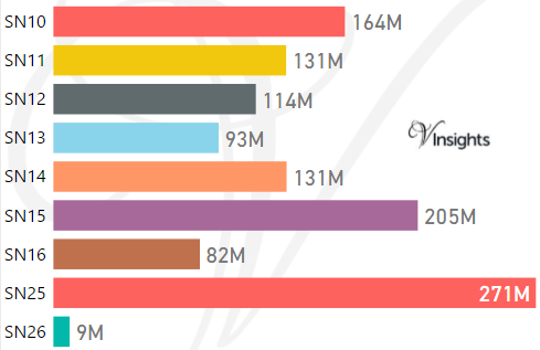
*M represent Million Pounds
Average & Median Sales Price By Postcode
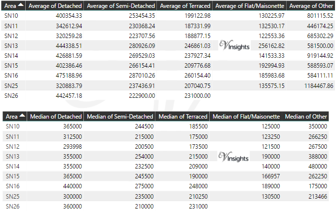
*Average and Median Sales Price are in Pounds
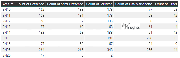
Total Number Of Sales By Postcode
Other Property Posts for Postcode Area SN
Schools for Postcode Area SN
- SN Postcode Area Property Market - SN1, SN2, SN3, SN4, SN5, SN6, SN7, SN8, SN9 School Details
- SN Postcode Area Property Market - SN10, SN11, SN12, SN13, SN14, SN15, SN16, SN25, SN26 School Details
All SN Postcodes Yearly & Trend Analysis Posts

Reference
SN Postcode Area As Per Wikipedia
136cfdf0-879e-4f78-af64-b7ca17771fe1|0|.0|27604f05-86ad-47ef-9e05-950bb762570c