22. February 2018 14:09
/
VInsights Team
/
/
Comments (0)
Please click here for the updated version of this post
This Post covers
Coverage Area of Postcode RH1 to RH9
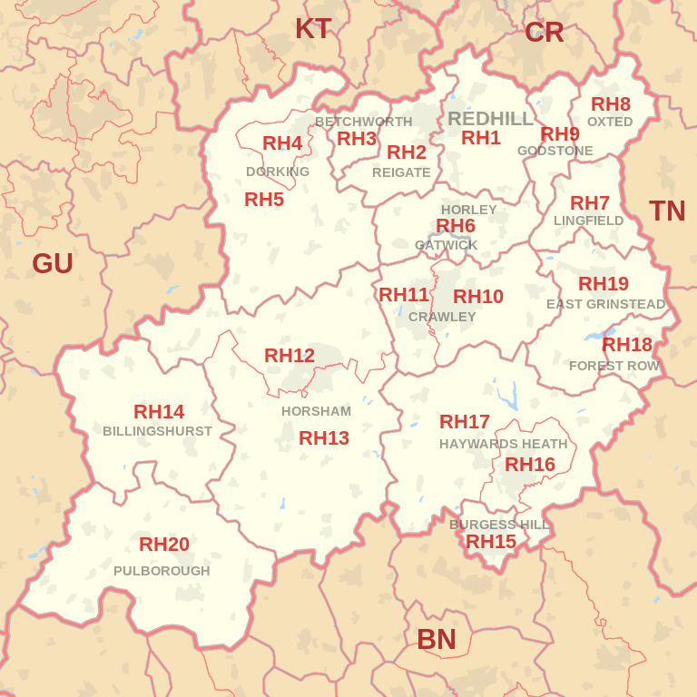 |
| Postcode |
Coverage Area |
Local Authority Area |
| RH1 |
Redhill, Merstham, Earlswood, South Earlswood, Whitebushes, Salfords,Nutfield Marsh,
South Nutfield, Bletchingley, Outwood
|
Reigate and Banstead, Tandridge
|
| RH2 |
Reigate, Woodhatch, South Park, Skimmington,
Leigh, Dawes Green, Bunce Common, Shellwood Cross,
Nalderswood, Sidlow, Irons Bottom |
Reigate and Banstead,
Mole Valley |
| RH3 |
Betchworth, Brockham, Buckland, Strood Green, Gadbrook |
Mole Valley |
| RH4 |
Betchworth (far west),Dorking, Pixham, Westcott |
Mole Valley |
| RH5 |
Abinger, Capel, Westhumble, Mickleham, Ockley, Holmbury St Mary |
Mole Valley, Guildford |
| RH6 |
Gatwick Airport,Horley, Burstow |
Reigate and Banstead, Crawley, Mole Valley, Tandridge |
| RH7 |
Lingfield, Dormansland, Crowhurst |
Tandridge |
| RH8 |
Oxted, Limpsfield, Limpsfield Chart, Hurst Green, Merle Common, Tandridge, Crowhurst Lane End |
Tandridge |
| RH9 |
Godstone, South Godstone |
Tandridge |
- M represents Million Pounds
- Total value includes Property Type Other apart from Detached, Semi-Detached, Terraced, Flat/Masionette
Schools for Postcode Area RH
- RH Postcode Area - RH1, RH2, RH3, RH4, RH5, RH6, RH7, RH8, RH9 School Details
- RH Postcode Area - RH10, RH11, RH12, RH13, RH14, RH15, RH16, RH17, RH18, RH19, RH20 School Details
Property Posts for Postcode Area RH
All RH Postcodes Yearly & Trend Analysis Posts

Reference
RH Postcode Area As Per Wikipedia
4fca8028-1f91-4db8-acee-3702d8b967aa|0|.0|27604f05-86ad-47ef-9e05-950bb762570c
Tags :