14. April 2018 19:31
/
VInsights Team
/
/
Comments (0)
Please click here for the updated version of this post
This Post covers
Coverage Area of Postcode OL10 to OL16
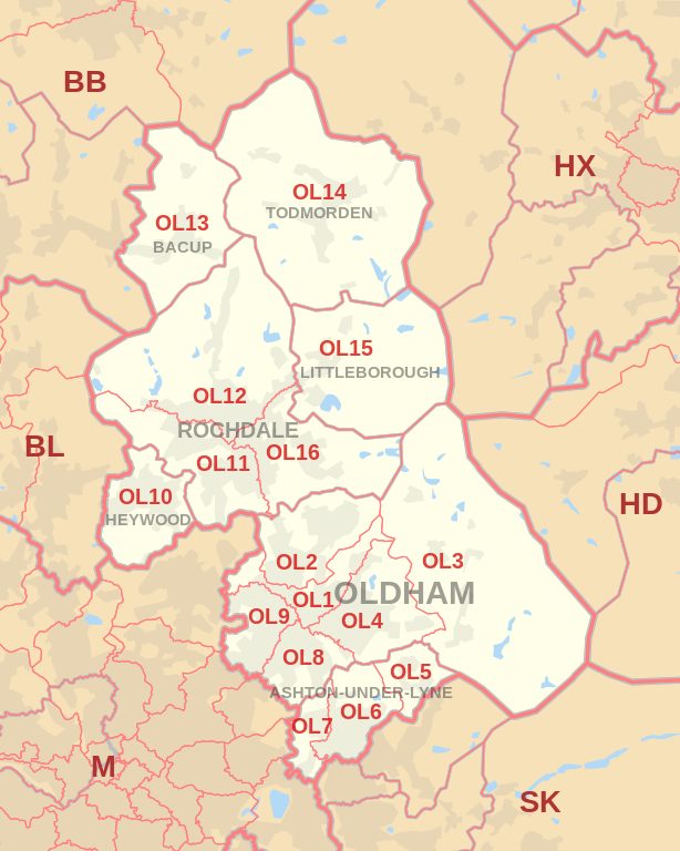 |
| Postcode |
Coverage Area |
Local Authority Area |
| OL10 |
Heywood |
Rochdale |
| OL11 |
Ashworth, Balderstone, Castleton, Norden, Rochdale |
Rochdale |
| OL12 |
Buckley, Facit, Great Howarth, Healy, Hurstead,
Rochdale, Shawforth, Wardle, Whitworth |
Rochdale, Rossendale |
| OL13 |
Bacup, Britannia, Stacksteads |
Rossendale, Lancashire |
| OL14 |
Cornholme, Todmorden, Eastwood, Walsden |
Calderdale, West Yorkshire |
| OL15 |
Littleborough, Shore, Smithybridge, Summit |
Rochdale |
| OL16 |
Burnedge, Firgrove, Hurstead, Milnrow, Rochdale, Smallbridge, Thornham |
Rochdale |
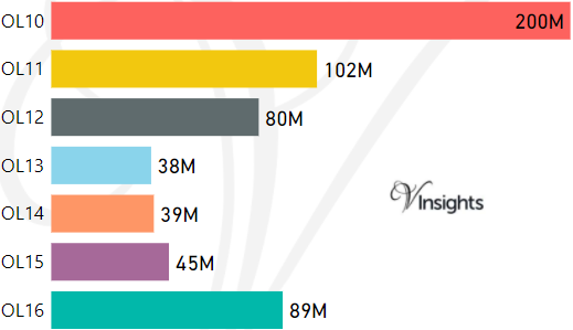
- M represents Million Pounds
- Total value includes Property Type Other apart from Detached, Semi-Detached, Terraced, Flat/Masionette
Schools for Postcode Area OL
- OL Postcode Area - OL1, OL2, OL3, OL4, OL5, OL6, OL7, OL8, OL9 School Details
- OL Postcode Area - OL10, OL11, OL12, OL13, OL14, OL15, OL16 School Details
Property Posts for Postcode Area OL
c0a5b0a5-7537-4430-8280-3956e99d90c6|0|.0|27604f05-86ad-47ef-9e05-950bb762570c
Tags :