Please click here for the updated version of this post
This Post covers
- Coverage Area of Postcode NR1 to NR9
- Total Sales By Postcode NR1 to NR9
- Average & Median Sales Price By Postcode NR1 to NR9
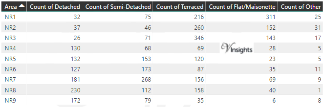
- Total Number of Sales By Postcode NR1 to NR9
- Schools for Postcode Area NR
- Other Property Posts For Postcode Area NR
Coverage Area of Postcode NR1 to NR9
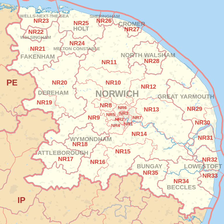 |
| Postcode |
Coverage Area |
Local Authority Area |
| NR1 |
Thorpe Hamlet, (parts of) City Centre,
areas close to Thorpe Road Mail Centre |
Norwich |
| NR2 |
Eaton, western and south-western parts of Norwich
and parts of the city centre |
Norwich |
| NR3 |
N part of Norwich, within the
ring-road: Upper Hellesdon, New Catton |
Norwich, Broadland |
| NR4 |
Villages W and SW of Norwich: Cringleford, Colney, Keswick |
South Norfolk |
| NR5 |
W and NW suburbs of Norwich: Bowthorpe, Costessey |
Norwich, South Norfolk |
| NR6 |
N and NW suburbs of Norwich: Old Catton, Hellesdon |
Norwich, Broadland |
| NR7 |
E and SE suburbs of Norwich: Sprowston, Thorpe St. Andrew, Heartsease |
Norwich, Broadland |
| NR8 |
Suburbs and villages NW of Norwich: Drayton, Taverham, Ringland |
Broadland, South Norfolk |
| NR9 |
Villages W and NW of Norwich: Barford, Bawburgh,
Hethersett, Honingham, Lenwade, Little Melton,
Lyng, Marlingford and Colton, Weston Longville |
Broadland |
Total Sales By Postcode
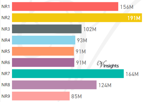
*M represents Million Pounds
Average & Median Sales Price By Postcode 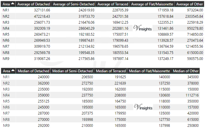
* Average and Medium Sales Price is in Pounds
Total Number Of Sales By Postcode
Schools for Postcode Area NR
- NR Postcode Area - NR1, NR2, NR3, NR4, NR5, NR6, NR7, NR8, NR9 School Details
- NR Postcode Area - NR10, NR11, NR12, NR13, NR14, NR15, NR16, NR17, NR18, NR19 School Details
- NR Postcode Area - NR20, NR21, NR22, NR23, NR24, NR25, NR26, NR27, NR28, NR29 School Details
- NR Postcode Area - NR30, NR31, NR32, NR33, NR34, NR35 School Details
Other Property Posts for Postcode Area NR
- NR Postcode Area - NR10, NR11, NR12, NR13, NR14, NR15, NR16, NR17, NR18, NR19 Property Market 2016
- NR Postcode Area - NR20, NR21, NR22, NR23, NR24, NR25, NR26, NR27, NR28, NR29 Property Market 2016
- NR Postcode Area - NR30, NR31, NR32, NR33, NR34, NR35 Property Market 2016
All NR Postcodes Yearly & Trend Analysis Posts

Reference
NR Postcode Area As Per Wikipedia
9b83b999-eb26-4fbd-a6b0-b29bf9c2494e|0|.0|27604f05-86ad-47ef-9e05-950bb762570c