7. April 2018 19:19
/
VInsights Team
/
/
Comments (0)
Please click here for the updated version of this post
This Post covers
Coverage Area of Postcode LE1 to LE9
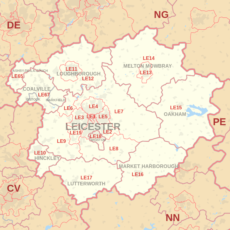 |
| Postcode |
Coverage Area |
Local Authority Area |
| LE1 |
Leicester |
Leicester |
| LE2 |
Oadby, Knighton, Highfields, Aylestone,
Glen Parva, Stoughton, Little Stretton |
Leicester, Oadby and Wigston,
Harborough, Blaby |
| LE3 |
Braunstone, Glenfield, New Parks,Groby Road (A50),
Leicester Forest East, Westcotes |
Leicester, Blaby |
| LE4 |
Beaumont Leys, Belgrave, Birstall, Thurmaston |
Leicester, Charnwood |
| LE5 |
Hamilton, Thurnby Lodge, Evington |
Leicester |
| LE6 |
Ratby, Groby, Newtown Linford |
Hinckley and Bosworth, Charnwood |
| LE7 |
Scraptoft, Anstey, Billesdon, Gaddesby, Hungarton,
Rearsby, Tilton on the Hill, Tugby, Cropston,
Thurcaston, Rothley, Barkby, Syston, Wanlip |
Charnwood, Harborough, Melton |
| LE8 |
Blaby, Great Glen, Fleckney, Kibworth, Peatling Magna, Countesthorpe, Whetstone |
Harborough, Blaby |
| LE9 |
Kirby Muxloe, Stoney Stanton, Cosby, Huncote, Croft, Desford, Newbold Verdon, Kirkby Mallory, Earl Shilton, Barwell, Sapcote, Sutton in the Elms, Broughton Astley, Thurlaston |
Hinckley and Bosworth,Harborough |
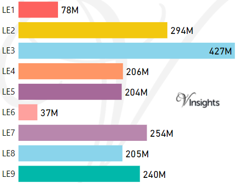
- M represents Million Pounds
- Total value includes Property Type Other apart from Detached, Semi-Detached, Terraced, Flat/Masionette
Schools for Postcode Area LE
- LE Postcode Area - LE1, LE2, LE3, LE4, LE5, LE6, LE7, LE8, LE9 School Details
- LE Postcode Area - LE10, LE11, LE12, LE13, LE14, LE15, LE16, LE17, LE18, LE19, LE65, LE67 School Details
Property Posts for Postcode Area LE
714482c5-acdf-417d-a9c9-b37c29e376d6|0|.0|27604f05-86ad-47ef-9e05-950bb762570c
Tags :