Please click here for the updated version of this post
This Post covers
- Coverage Area of Postcode L20 to L29
- Total Sales By Postcode L20 to L29
- Average & Median Sales Price By Postcode L20 to L29
- Total Number of Sales By Postcode L20 to L29
- Property Posts For Postcode Area L
- Schools for Postcode Area L
Coverage Area of Postcode L20 to L29
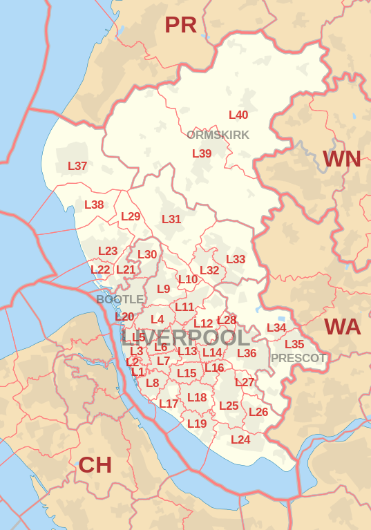 |
| Postcode |
Coverage Area |
Local Authority Area |
| L20 |
Bootle, Orrell,Kirkdale |
Sefton, Liverpool |
| L21 |
Ford, Litherland, Seaforth |
Sefton, Liverpool |
| L22 |
Waterloo |
Sefton |
| L23 |
Blundellsands, Brighton-le-Sands, Crosby, Little Crosby, Thornton |
Sefton |
| L24 |
Hale, Speke |
Halton,Liverpool |
| L25 |
Belle Vale, Gateacre, Hunts Cross, Woolton, Halewood |
Liverpool, Knowsley |
| L26 |
Halewood |
Liverpool, Knowsley |
| L27 |
Netherley |
Liverpool |
| L28 |
Stockbridge Village |
Liverpool, Knowsley |
| L29 |
Lunt, Sefton Village |
Sefton |
Total Sales By Postcode
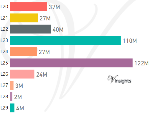
*M represent Million Pounds
Average & Median Sales Price By Postcode
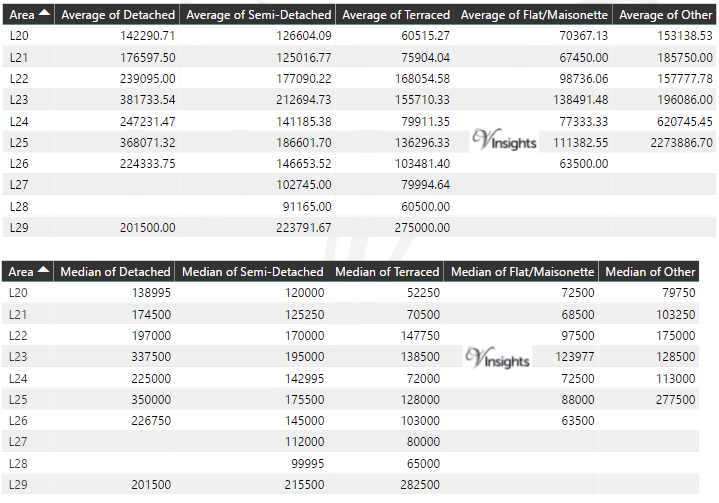
*Average and Median Sales Price are in Pounds
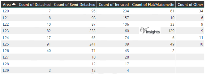
Total Number Of Sales By Postcode
Property Posts for Postcode Area L
Schools for Postcode Area L
- L Postcode Area - L1, L2, L3, L4, L5, L6, L7, L8, L9 School Details
- L Postcode Area - L10, L11, L12, L13, L14, L15, L16, L17, L18, L19 School Details
- L Postcode Area - L20, L21, L22, L23, L24, L25, L26, L27, L28, L29 School Details
- L Postcode Area - L30, L31, L32, L33, L34, L35, L36, L37, L38, L39, 40 School Details
All North West England Postcode Area Posts

Reference
L Postcode Area As Per Wikipedia
a8940b69-8fde-424d-99b6-dc3bc10f2892|0|.0|27604f05-86ad-47ef-9e05-950bb762570c