20. February 2018 14:09
/
VInsights Team
/
/
Comments (0)
Please click here for the updated version of this post
This Post covers
Coverage Area of Postcode HP5 to HP9
 |
| Postcode |
Coverage Area |
Local Authority Area |
| HP5 |
Chesham, Ashley Green, Bellingdon, Botley, Chartridge, Hawridge, Latimer, Lye Green, Newtown, Waterside, Whelpley Hill
|
Chiltern |
| HP6 |
Amersham (north), Chesham Bois, Hyde Heath, Little Chalfont |
Chiltern |
| HP7 |
Amersham (south), Coleshill, Little Chalfont, Little Missenden, Penn Street, Winchmore Hill |
Chiltern |
| HP8 |
Chalfont St Giles |
Chiltern |
| HP9 |
Beaconsfield, Forty Green, Holtspur, Jordans, Knotty Green, Seer Green |
South Bucks, Chiltern |
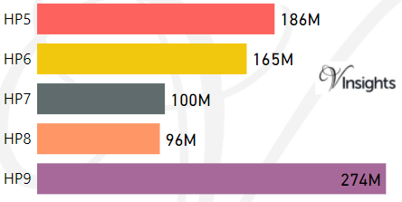
- M represents Million Pounds
- Total value includes Property Type Other apart from Detached, Semi-Detached, Terraced, Flat/Masionette
Schools for Postcode Area HP
- HP Postcode Area - HP1, HP2, HP3, HP4 School Details
- HP Postcode Area - HP5, HP6, HP7, HP8, HP9 School Details
- HP Postcode Area - HP10, HP11, HP12, HP13, HP14,HP15,HP16 School Details
- HP Postcode Area - HP17, HP18, HP19, HP20, HP21, HP22, HP23, HP27 School Details
Property Posts for Postcode Area HP
All HP Postcodes Yearly & Trend Analysis Posts

Reference
HP Postcode Area As Per Wikipedia
d84c24b3-9d06-4fb9-bf74-45bd6605b6c5|0|.0|27604f05-86ad-47ef-9e05-950bb762570c
Tags :