22. April 2018 20:07
/
VInsights Team
/
/
Comments (0)
Please click here for the updated version of this post
This Post covers
Coverage Area of Postcode HD1 to HD9
|
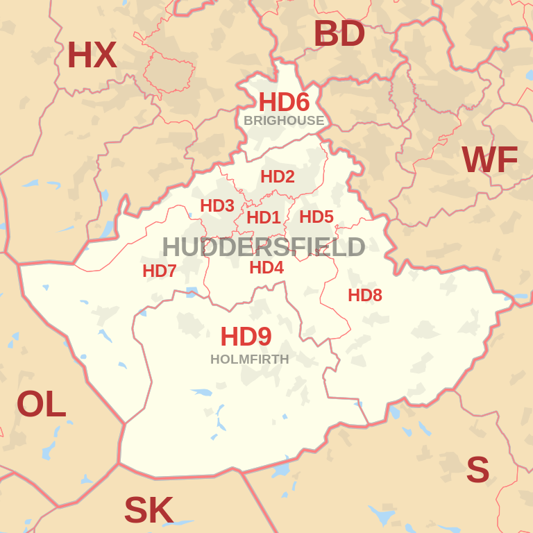
|
| Postcode |
Coverage Area |
Local Authority Area |
| HD1 |
Huddersfield Town Centre, Hillhouse, Lockwood, Marsh, Paddock |
Kirklees |
| HD2 |
Birkby, Brackenhall, Bradley, Deighton, Fartown, Fixby, Sheepridge |
Kirklees |
| HD3 |
Lindley, Longwood, Marsh, Milnsbridge, Oakes, Outlane, Quarmby, Paddock, Salendine Nook, Scammonden |
Kirklees |
| HD4 |
Berry Brow, Cowlersley, Crosland Moor, Farnley Tyas, Netherton, Newsome, Lowerhouses, Stocksmoor |
Kirklees |
| HD5 |
Almondbury, Dalton, Kirkheaton, Moldgreen, Rawthorpe, Waterloo |
Kirklees |
| HD6 |
Bailiff Bridge, Brighouse, Clifton, Rastrick |
Calderdale |
| HD7 |
Golcar, Linthwaite, Marsden, Scapegoat Hill, Slaithwaite |
Kirklees |
| HD8 |
Clayton West, Denby Dale, Emley, Fenay Bridge, Kirkburton, Lepton, Scissett, Shelley, Shepley, Skelmanthorpe |
Kirklees |
| HD9 |
Birdsedge, Brockholes, Hepworth, Holme, Holmfirth, Honley, Meltham, Scholes, Upperthong, Wooldale |
Kirklees |
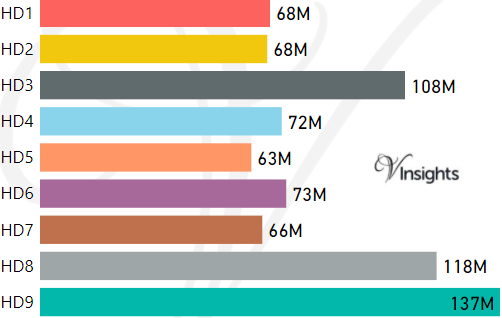
- M represents Million Pounds
- Total value includes Property Type Other apart from Detached, Semi-Detached, Terraced, Flat/Masionette
Schools for Postcode Area HD
Property Posts for Postcode Area HD
1744bf4c-828b-43fc-ab28-1ba59738b364|0|.0|27604f05-86ad-47ef-9e05-950bb762570c
Tags :