Please click here for the updated version of this post
This post covers
- Coverage Area of Postcode FY1 to FY8
- Total Sales By Postcode FY1 to FY8
- Average & Median Sales Price By Postcode FY1 to FY8
- Total Number of Sales By Postcode FY1 to FY8
- Schools for Postcode Area FY
- Property Posts for Postcode Area FY
Coverage Area of Postcode FY1 to FY8
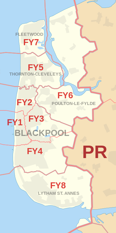 |
| Postcode |
Coverage Area |
Local Authority Area |
| FY1 |
Blackpool, North Shore |
Blackpool |
| FY2 |
Bispham |
Blackpool |
| FY3 |
Grange Park, Layton, Marton, Staining, Stanley Park |
Blackpool, Fylde, Wyre |
| FY4 |
Blackpool, Marton, South Shore, Squires Gate, Starr Gate |
Blackpool, Fylde |
| FY5 |
Blackpool, Anchorsholme, Little Bispham, Thornton-Cleveleys |
Blackpool, Wyre |
| FY6 |
Poulton-le-Fylde, Hambleton, Knott End-on-Sea,
Preesall, Singleton, Stalmine |
Wyre, Fylde |
| FY7 |
Fleetwood |
Wyre |
| FY8 |
Lytham St. Annes, Moss Side |
Fylde |
Total Sales By Postcode
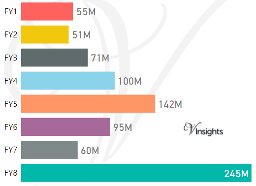
*M represents Million Pounds
Average & Median Sales Price By Postcode
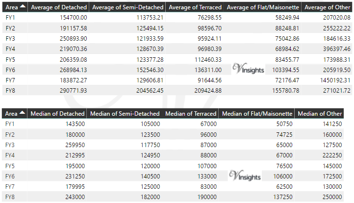
* Average and Medium Sales Price is in Pounds
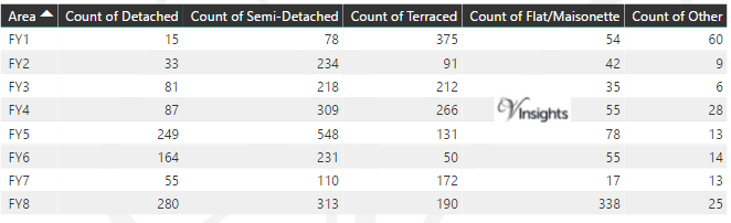
Total Number Of Sales By Postcode
Schools for Postcode Area FY
Property Posts for Postcode Area FY
All North West England Postcode Area Posts

Reference
FY Postcode Area As Per Wikipedia
7c342509-ddf1-47bb-9b71-43e583a9aff8|0|.0|27604f05-86ad-47ef-9e05-950bb762570c