22. April 2018 19:15
/
VInsights Team
/
/
Comments (0)
Please click here for the updated version of this post
This Post covers
Coverage Area of Postcode DN1 to DN9
|
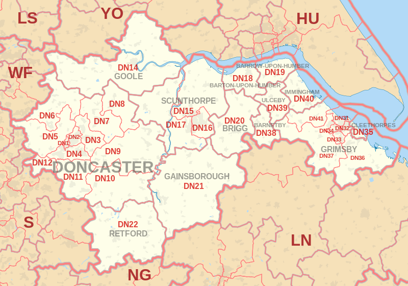
|
| Postcode |
Coverage Area |
Local Authority Area |
| DN1 |
Doncaster Town Centre |
Doncaster |
| DN2 |
Intake, Wheatley, Wheatley Hills |
Doncaster |
| DN3 |
Armthorpe, Barnby Dun, Branton, Edenthorpe, Kirk Sandall |
Doncaster |
| DN4 |
Balby, Belle Vue, Bessacarr, Cantley, Hexthorpe, Warmsworth |
Doncaster |
| DN5 |
Arksey, Barnburgh, Bentley, Cadeby, Cusworth, Harlington,
High Melton, Scawsby, Scawthorpe, Sprotborough, Sunnyfields, Toll Bar |
Barnsley, Doncaster, Rotherham |
| DN6 |
Adwick-le-Street, Askern, Campsall, Carcroft,
Moss, Norton, Sutton, Walden Stubbs, Woodlands |
Doncaster, Selby |
| DN7 |
Dunsville, Dunscroft, Fishlake, Hatfield,
Hatfield Woodhouse, Lindholme, Stainforth |
Doncaster |
| DN8 |
Moorends, Sandtoft, Thorne |
Doncaster |
| DN9 |
Epworth, Finningley, Haxey, Auckley,
Owston Ferry, Belton, Westwoodside |
Doncaster, North Lincolnshire |
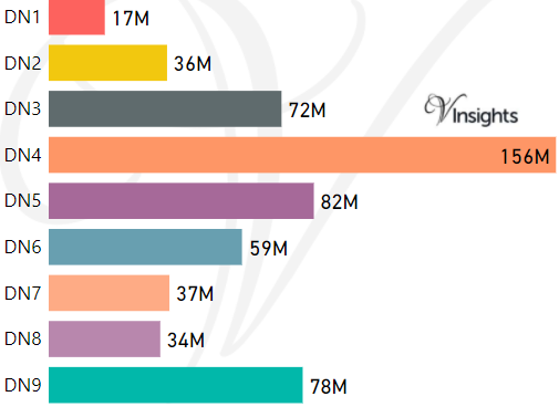
- M represents Million Pounds
- Total value includes Property Type Other apart from Detached, Semi-Detached, Terraced, Flat/Masionette
Schools for Postcode Area DN
- DN Postcode Area - DN1, DN2, DN3, DN4, DN5, DN6, DN7, DN8, DN9 School Details
- DN Postcode Area - DN10, DN11, DN12, DN14, DN15, DN16, DN17, DN18, DN19 School Details
- DN Postcode Area - DN20, DN21, DN22, DN31, DN32, DN33, DN34, DN35 School Details
- DN Postcode Area - DN36, DN37, DN38, DN39, DN40, DN41 School Details
Property Posts for Postcode Area DN
480e47c2-dbeb-4911-83b8-9720cb516cec|0|.0|27604f05-86ad-47ef-9e05-950bb762570c
Tags :