Please click here for the updated version of this post
This Post covers
- Coverage Area of Postcode DA1 to DA9
- Total Sales By Postcode DA1 to DA9
- Average & Median Sales Price By Postcode DA1 to DA9
- Total Number of Sales By Postcode DA1 to DA9
- Multi Year Property Trend Analysis For Postcode DA1 to DA9
- Schools for Postcode Area DA
- Posts for Postcode Area DA
Coverage Area of Postcode DA1 to DA9
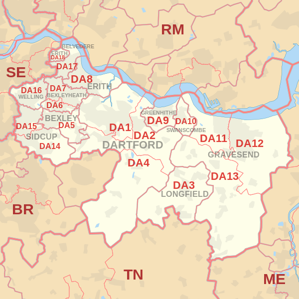 |
| Postcode |
Coverage Area |
Local Authority Area |
| DA1 |
Dartford, Crayford, Barnes Cray |
Bexley, Dartford |
| DA2 |
Dartford (east), Stone, Wilmington, Bean, Hawley, Darenth, part of Joyden's Wood |
Dartford, Sevenoaks |
| DA3 |
Longfield, Hartley, New Ash Green, New Barn, Fawkham |
Dartford, Gravesham, Sevenoaks |
| DA4 |
Farningham, Eynsford, South Darenth, Sutton-at-Hone, Horton Kirby |
Dartford, Sevenoaks |
| DA5 |
Bexley, parts of Albany Park and Joyden's Wood |
Bexley, Dartford |
| DA6 |
Bexleyheath, Upton |
Bexley |
| DA7 |
Bexleyheath (north), Barnehurst |
Bexley |
| DA8 |
Erith, Northumberland Heath, Slade Green |
Bexley |
| DA9 |
Greenhithe, Stone |
Dartford |
Total Sales By Postcode in 2016
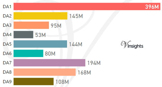
*M represents millions
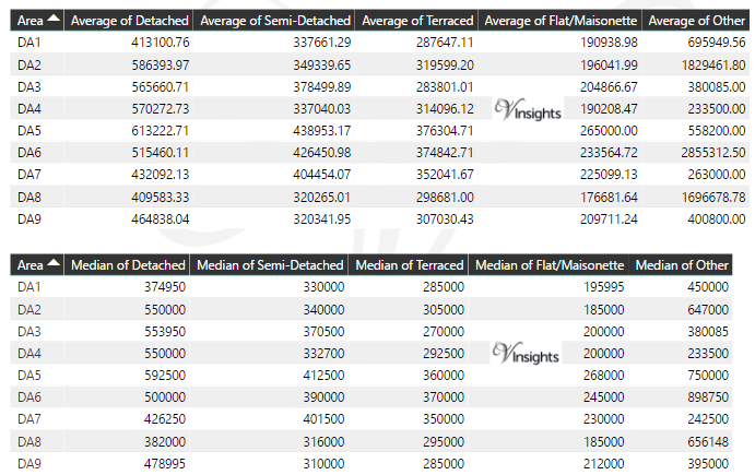
Average & Median Sales Price By Postcode in 2016
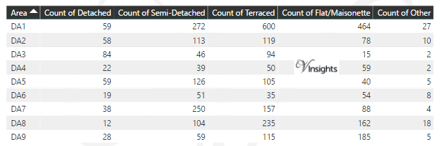
Total Number Of Sales By Postcode in 2016
Multi Year Trend Analysis By Postcode
Schools for Postcode Area DA
- DA Postcode Area - DA1, DA2, DA3, DA4, DA5, DA6, DA7, DA8, DA9 School Details
- DA Postcode Area - DA10, DA11, DA12, DA13, DA14, DA15, DA16, DA17, DA18 School Details
Posts for Postcode Area DA
All DA Postcode Area Posts

Reference
DA Postcode Area As Per Wikipedia
f0de4575-c599-40e3-a0e4-9c32c325851b|0|.0|27604f05-86ad-47ef-9e05-950bb762570c