Please click here for the updated version of this post
This Post covers
- Coverage Area of Postcode CH1 to CH8
- Total Sales By Postcode CH1 to CH8
- Average & Median Sales Price By Postcode CH1 to CH8
- Total Number of Sales By Postcode CH1 to CH8
- Other Property Posts For Postcode Area CH
- Schools for Postcode Area CH
Coverage Area of Postcode CH1 to CH8
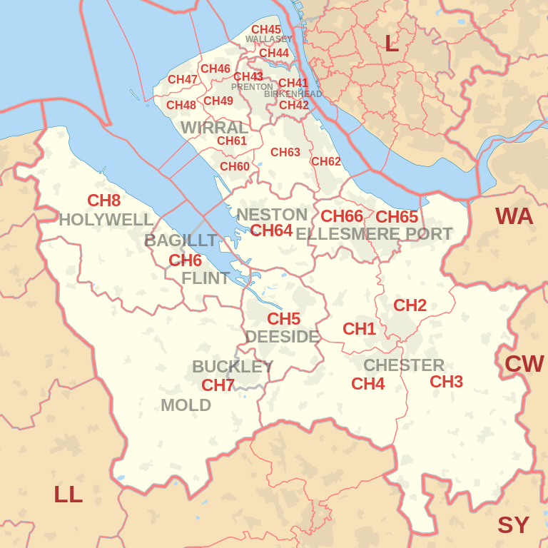 |
| Postcode |
Coverage Area |
Local Authority Area |
| CH1 |
Blacon, Chester, Higher Ferry, Capenhurst, Backford |
Cheshire West and Chester,
Flintshirel |
| CH2 |
Backford, Chester, Elton, Hoole, Ince, Mickle Trafford,
Moston, Newton by Chester, Upton by Chester |
Cheshire West and Chester |
| CH3 |
Boughton, Chester, Huntington, Mouldsworth,Tarvin,
Tattenhall, Farndon, Waverton,Saighton,Upton by Chester |
Cheshire West and Chester |
| CH4 |
Chester, Curzon Park, Handbridge, Lache, Pulford,
Penyffordd, Broughton, Saltney |
Cheshire West and Chester,
Flintshire |
| CH5 |
Connah's Quay, Shotton, Queensferry, Sealand,
Garden City, Sandycroft, Hawarden, Ewloe, Mancot |
Flintshire |
| CH6 |
Flint, Oakenholt, Flint Mountain, The Nant, Bagillt |
Flintshire |
| CH7 |
Buckley, Leeswood, Treuddyn, Llanarmon-yn-Ial,
Caerwys, Mold, Northop Hall, Drury |
Flintshire,
Denbighshire |
| CH8 |
Holywell, Milwr, Holway, Carmel, Lloc, Bryn Celyn,
Greenfield, Halkyn, Lixwm, Talacre |
Flintshire |
Total Sales By Postcode
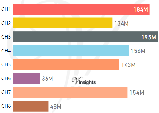
*M represents Million Pounds
Average & Median Sales Price By Postcode
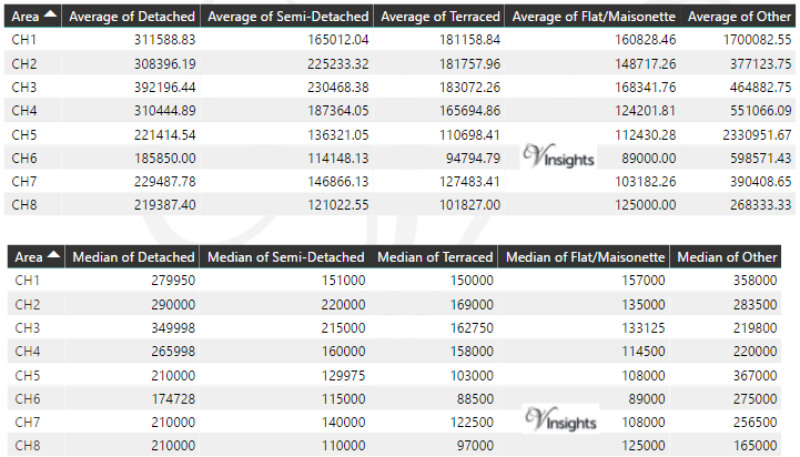
* Average and Medium Sales Price is in Pounds
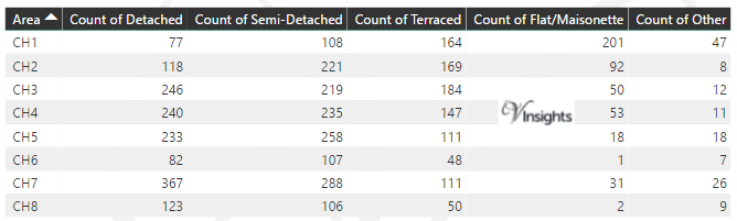
Total Number Of Sales By Postcode
Property Posts for Postcode Area CH
Schools for Postcode Area CH
- CH Postcode Area - CH1, CH2, CH3, CH4, CH5, CH6, CH7, CH8 School Details
- CH Postcode Area - CH41, CH42, CH43, CH44, CH45, CH46, CH47, CH48, CH49 School Details
- CH Postcode Area - CH60, CH61, CH62, CH63, CH64, CH65, CH66 School Details
All North West England Postcode Area Posts

Reference
CH Postcode Area As Per Wikipedia
ec68da87-a852-4919-a46e-7aacba76b998|0|.0|27604f05-86ad-47ef-9e05-950bb762570c