Please click here for the updated version of this post
This Post covers
- Coverage Area of Postcode NE20 to NE29
- Total Sales By Postcode NE20 to NE29 in 2016
- Average & Median Sales Price By Postcode NE20 to NE29 in 2016
- Spread of Sales Price By Postcode NE20 to NE29 in 2016
- Total Number of Sales By Postcode NE20 to NE29 in 2016
- Property Posts for Postcode Area NE
- Schools for Postcode Area NE
Coverage Area of Postcode NE20 to NE29
|
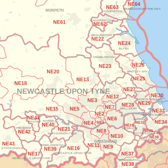
|
| Postcode |
Coverage Area |
Local Authority Area |
| NE20 |
Ponteland |
Northumberland |
| NE21 |
Blaydon, Winlaton |
Gateshead |
| NE22 |
Bedlington, Hartford Bridge, Monkseaton |
Northumberland |
| NE23 |
Cramlington |
Northumberland |
| NE24 |
Blyth, Newsham, Cowpen, Cambois |
Northumberland |
| NE25 |
Monkseaton, New Hartley, Holywell, Seaton Delaval |
North Tyneside, Northumberland |
| NE26 |
Whitley Bay, Seaton Sluice |
North Tyneside, Northumberland |
| NE27 |
Shiremoor, West Allotment, Backworth, Holystone, Murton Village |
North Tyneside |
| NE28 |
Battle Hill, Willington, Wallsend, North Tyne Tunnel |
North Tyneside |
| NE29 |
North Shields, Royal Quays, Billy Mill, New York |
North Tyneside |
Total Sales By Postcode in 2016
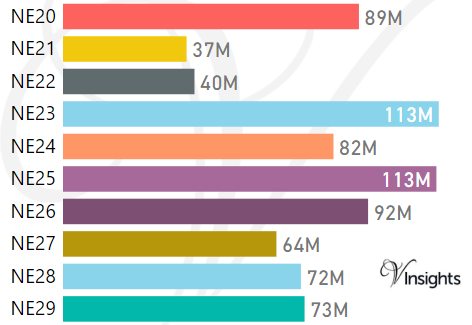
*M represents Million Pounds
Average & Median Sales Price By Postcode in 2016
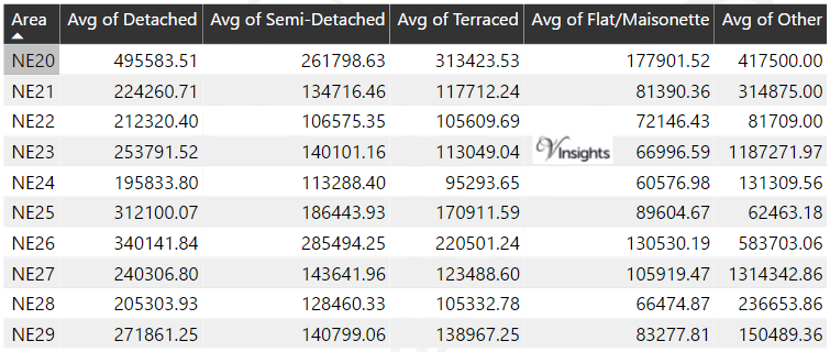
*Average and Median Sales Price are in Pounds
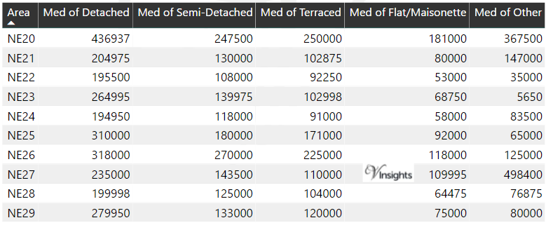
Spread of Sales Price By Postcode in 2016
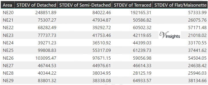
*STDEV is Standard Deviation
For example,
- Say the average detached property price for postcode XYZ is £300 K and ST. DEV. is 30 K.
- It means that most detached properties in postcode XYZ (about 68%) has price within one ST. Dev. i.e. the price range is £270K - £330K.
- All-most all detached property price (95%) in postcode XYZ lie between two ST. Dev. i.e. £240 K - £360 K
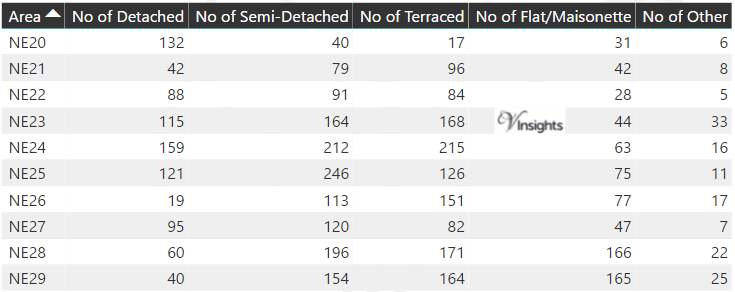
Total Number Of Sales By Postcode in 2016
Property Posts for Postcode Area NE
Schools for Postcode Area NE
- NE Postcode Area - NE1, NE2, NE3, NE4, NE5, NE6, NE7, NE8, NE9 School Details
- NE Postcode Area - NE10, NE11, NE12, NE13, NE15, NE16, NE17, NE18, NE19 School Details
- NE Postcode Area - NE20, NE21, NE22, NE23, NE24, NE25, NE26, NE27, NE28, NE29 School Details
- NE Postcode Area - NE30, NE31, NE32, NE33, NE34, NE35, NE36, NE37, NE38, NE39 School Details
- NE Postcode Area - NE40, NE41, NE42, NE43, NE44, NE45, NE46, NE47, NE48, NE49 School Details
- NE Postcode Area - NE61, NE62, NE63, NE64, NE65, NE66, NE67, NE68, NE69, NE70, NE71 School Details
North East England Postcode Area Posts

Reference
NE Postcode Area As Per Wikipedia
2ab073bf-a9bf-4f93-a22f-21d81f19ef50|0|.0|27604f05-86ad-47ef-9e05-950bb762570c