Please click here for the updated version of this post
This Post covers
- Coverage Area of Postcode ME1 to ME9
- Total Sales By Postcode ME1 to ME9
- Average & Median Sales Price By Postcode ME1 to ME9
- Total Number of Sales By Postcode ME1 to ME9
- Multi Year Property Trend Analysis By Postcode ME1 to ME9
- Schools for Postcode Area ME
- Posts For Postcode Area ME
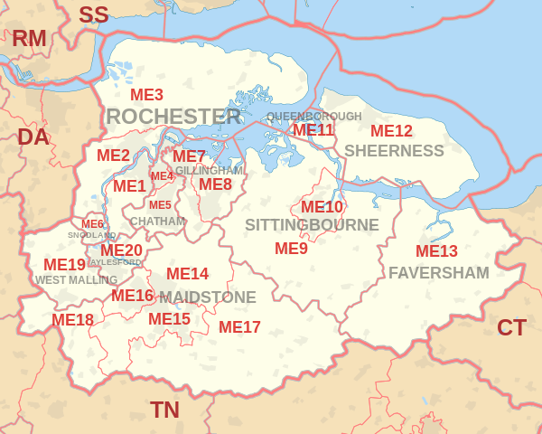
Coverage Area of Postcode ME1 to ME9
 |
| Postcode |
Coverage Area |
Local Authority Area |
| ME1 |
Rochester, Burham, Wouldham |
Medway, Tonbridge and Malling |
| ME2 |
Strood, Halling, Cuxton, Frindsbury |
Medway |
| ME3 |
Rural, Hoo Peninsula, Higham |
Medway, Gravesham |
| ME4 |
Chatham |
Medway |
| ME5 |
Walderslade, Blue Bell Hill, Lordswood, Luton |
Medway (and smaller areas within Maidstone,Tonbridge and Malling) |
| ME6 |
Snodland |
Tonbridge and Malling |
| ME7 |
Gillingham, Rainham, Hempstead |
Medway |
| ME8 |
Rainham, Parkwood, Twydall |
Medway |
| ME9 |
Newington, Teynham, Iwade and Rural |
Swale |
Total Sales By Postcode in 2016
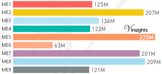
*M represent Million Pounds
Average & Median Sales Price By Postcode in 2016
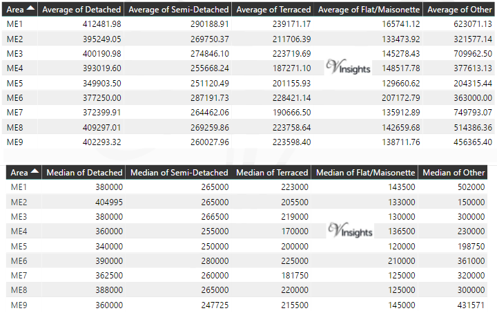
* Average and Median Sales Price is in Pounds
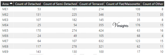
Total Number Of Sales By Postcode in 2016
Multi Year Property Trend Analysis By Postcode
Schools for Postcode Area ME
- ME Postcode Area - ME1, ME2, ME3, ME4, ME5, ME6, ME7, ME8, ME9 School Details
- ME Postcode Area - ME10, ME11, ME12, ME13, ME14, ME15, ME16, ME17, ME18, ME19, ME20 School Details
Posts for Postcode Area ME
All ME Postcodes Yearly & Trend Analysis Posts

Reference
ME Postcode Area As Per Wikipedia
76498ba5-7c08-4989-b4d0-6d0797ed9cd5|0|.0|27604f05-86ad-47ef-9e05-950bb762570c