Please click here for the updated version of this post
This Post covers
- Coverage Area of Postcode L1 to L9
- Total Sales By Postcode L1 to L9
- Average & Median Sales Price By Postcode L1 to L9
- Total Number of Sales By Postcode L1 to L9
- Property Posts For Postcode Area L
- Schools for Postcode Area L
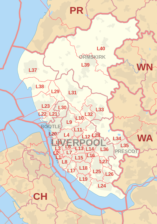
Coverage Area of Postcode L1 to L9
 |
| Postcode |
Coverage Area |
Local Authority Area |
| L1 |
City Centre |
Liverpool |
| L2 |
City Centre |
Liverpool |
| L3 |
City Centre, Everton, Vauxhall |
Liverpool |
| L4 |
Anfield, Kirkdale, Walton |
Liverpool |
| L5 |
Anfield, Everton, Kirkdale, Vauxhall |
Liverpool |
| L6 |
Anfield, City Centre, Everton, Fairfield, Kensington, Tuebrook |
Liverpool |
| L7 |
City Centre, Edge Hill, Fairfield, Kensington |
Liverpool |
| L8 |
City Centre, Dingle, Toxteth |
Liverpool |
| L9 |
Aintree, Fazakerley, Orrell Park, Walton |
Liverpool, Sefton |
Total Sales By Postcode
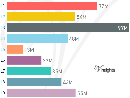
*M represent Million Pounds
Average & Median Sales Price By Postcode
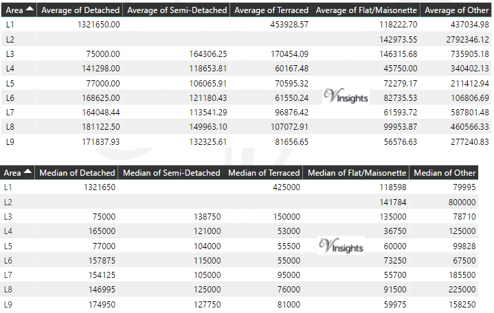
*Average and Median Sales Price are in Pounds
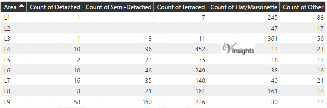
Total Number Of Sales By Postcode
Property Posts for Postcode Area L
Schools for Postcode Area L
- L Postcode Area - L1, L2, L3, L4, L5, L6, L7, L8, L9 School Details
- L Postcode Area - L10, L11, L12, L13, L14, L15, L16, L17, L18, L19 School Details
- L Postcode Area - L20, L21, L22, L23, L24, L25, L26, L27, L28, L29 School Details
- L Postcode Area - L30, L31, L32, L33, L34, L35, L36, L37, L38, L39, 40 School Details
All North West England Postcode Area Posts

Reference
L Postcode Area As Per Wikipedia
6b8bc998-6f95-4514-ab57-e85d8e69a8cd|0|.0|27604f05-86ad-47ef-9e05-950bb762570c